Contents
- Balrajeshwar Mandir
- Basilica of Our Lady of the Mount
- Hanuman Mandir
- Jari Mari Mata Mandir
- Jhulelal Mandir
- Jogeshwari Caves
- Kaka Baptista East Indian Museum
- Kanheri Caves
- Historical Context
- Development and Political History
- Inscriptions and Patronage
- Architecture and Design
- Lakshminarayan Mandir
- Magathane Caves
- Mahakali Caves
- Mandapeshwar Caves
- Nama Devi Mandir
- Oratory of Our Lady of Fatima
- Sanjay Gandhi National Park (Mulund Entrance)
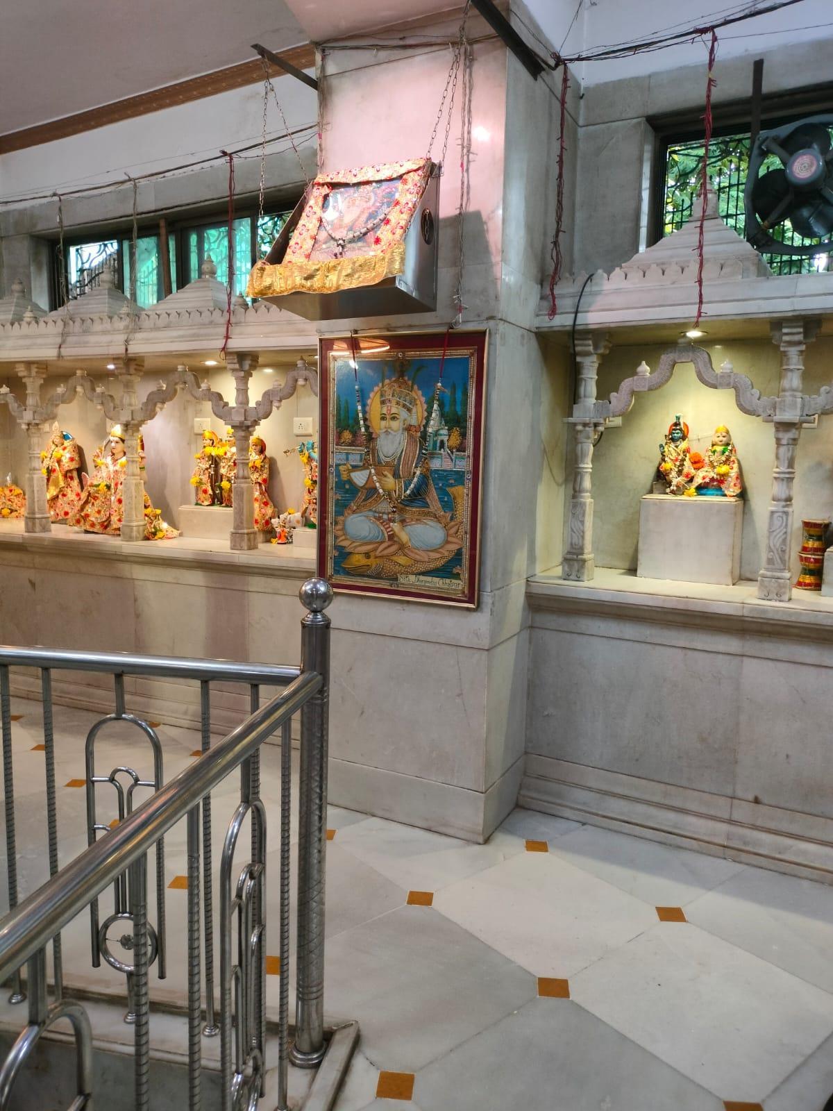
- Sri Guru Nanak Darbar
- Tara Devi Mandir
- Veergal/Eksar Hero Stones
- Sources
MUMBAI SUBURBAN
Cultural Sites
Last updated on 6 November 2025. Help us improve the information on this page by clicking on suggest edits or writing to us.
Balrajeshwar Mandir
The Balrajeshwar Mahadev Mandir is located at a major road junction in Mulund, Mumbai, near the locality’s check-naka and railway station. The shrine was established in the early 20th century, with its larger structure constructed in 1901. Its origins are associated with the discovery of a shivling by a Godhardas Khattau, after which he initially built a small shrine here.
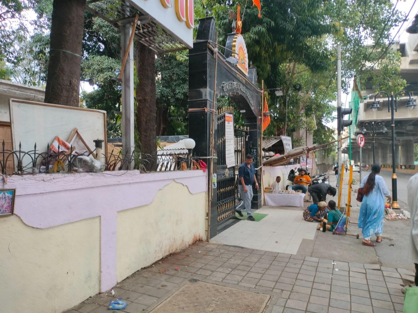
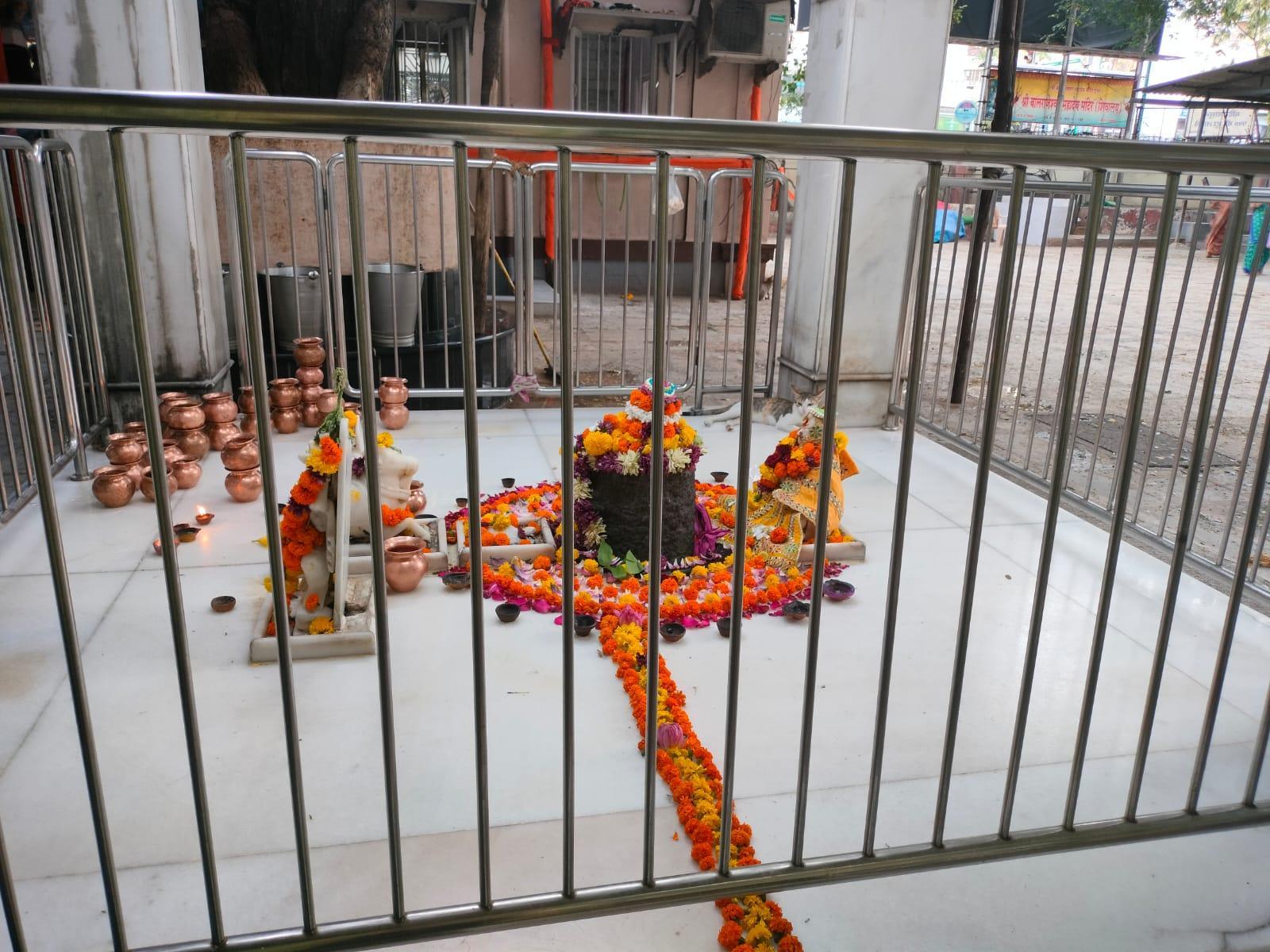
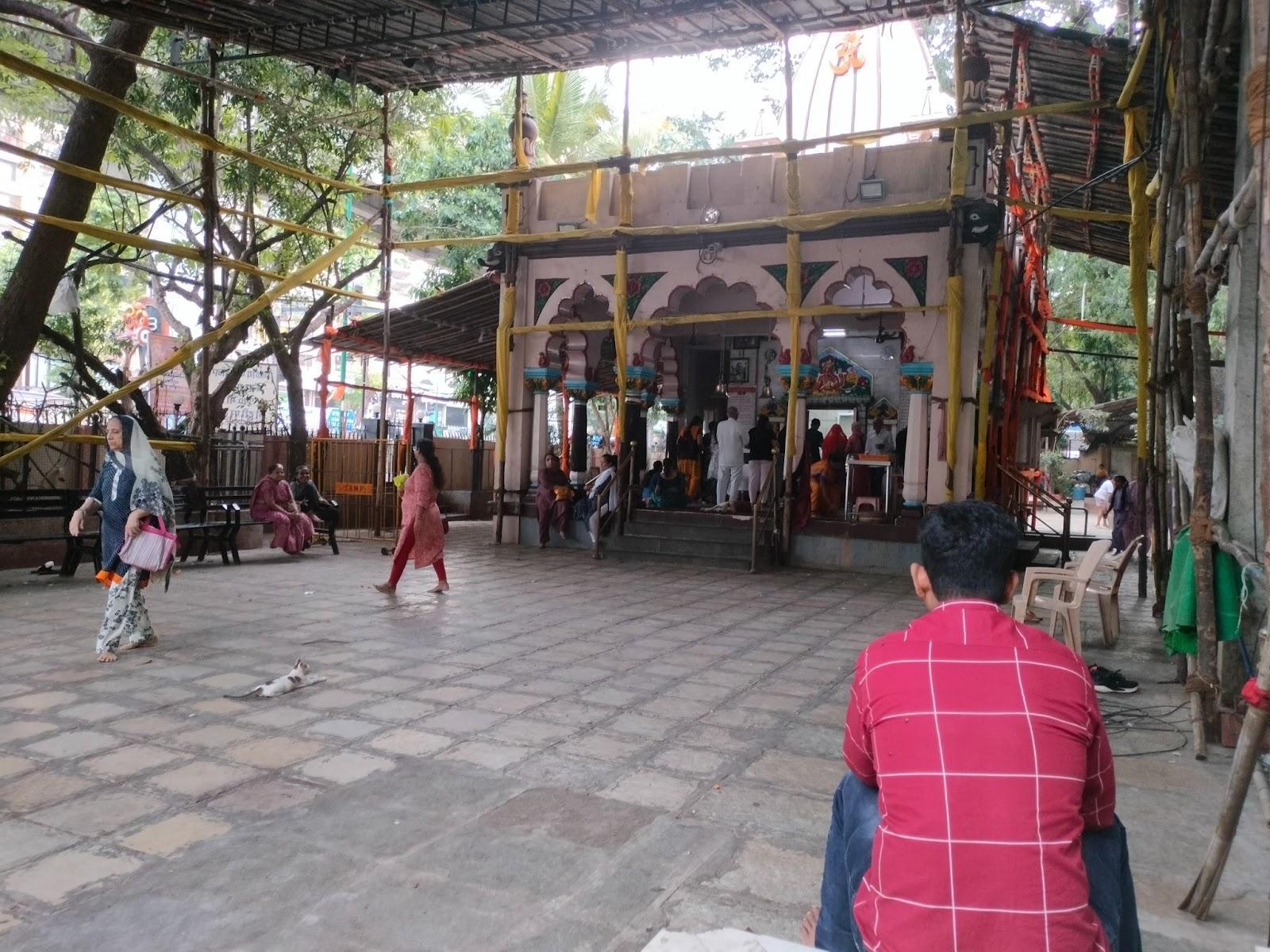
The mandir is dedicated to Bhagwan Shiv and remains active as a neighbourhood religious site. It is frequented by residents from nearby residential colonies and commuters from surrounding areas.
The site is also known for being associated with local traditions, including those involving marital blessings and other individual vows, though these vary across communities. The mandir remains part of a wider network of small but longstanding religious spaces in Mumbai’s eastern suburbs.
Basilica of Our Lady of the Mount
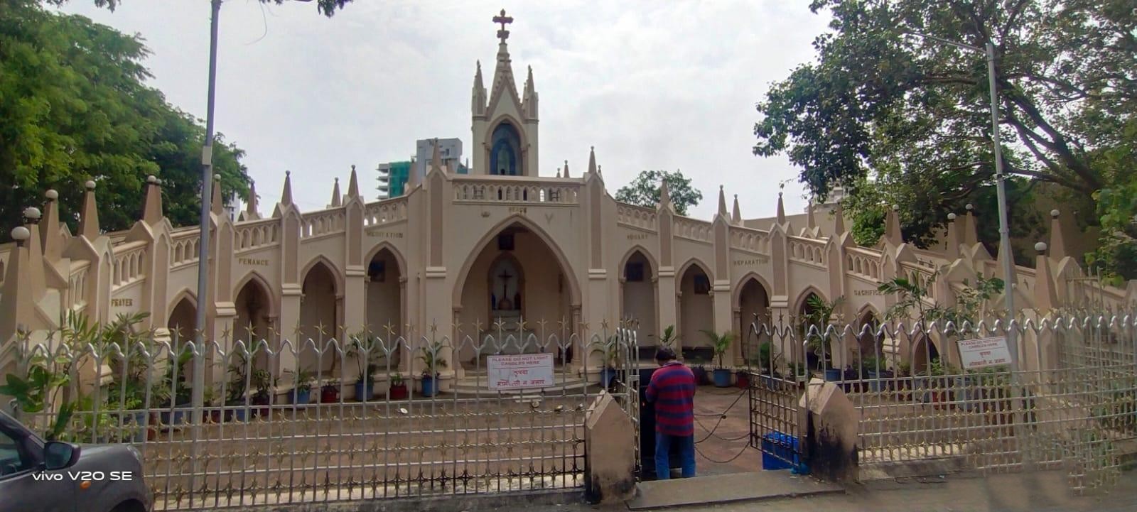
The Basilica of Our Lady of the Mount, more commonly known as Mount Mary Church, is one of the most prominent Roman Catholic churches in Mumbai. Situated on a hill at an elevation of 262 ft., the church overlooks the Arabian Sea and is a key landmark in Bandra.
![Front façade of the Basilica of Our Lady of the Mount, rebuilt in 1761 after the original structure was destroyed by Muscat pirates in the early 18th century.[1]](/media/culture/images/maharashtra/mumbai-suburban/cultural-sites/front-facade-of-the-basilica-o_cCsR4sx.png)
The church is believed to have originated as a small mud chapel built by Jesuit priests in the late 15th century, with a larger structure completed by 1640. Over the centuries, it underwent several reconstructions, particularly after attacks by pirates in the 1700s, which resulted in damage to the original statue of the Virgin Mary. A replacement statue was temporarily brought from St. Andrew’s Church, and later, the original was restored with modifications.
The current building, rebuilt in 1761, retains its semi-Gothic architectural style. Inside, the church features fiberglass murals depicting the life of the Virgin Mary, a seven-step altar, and a central statue of Mary holding the infant Jesus. A marble plaque of the Last Supper is engraved at the base of the altar.
Today, Mount Mary Church continues to be a major site of pilgrimage, especially during the annual Bandra Fair, and remains closely tied to the lived traditions of Mumbai’s Catholic community.
Hanuman Mandir
The Hanuman Mandir in Hanuman Pada, Mulund Colony, is a long-standing site of worship in eastern Mumbai. Although formally established in 1947, locals suggest that the site held devotional significance before this date.
Interestingly, the Mandir is colloquially referred to as “Paahadi ka Hanuman”, or “Hanuman of the Hill,” due to its location on an elevated slope accessed via Malabar Hill Road. He is, notably, regarded as the graam devta (village deity) of the locality where it lies which also derives its name from it.
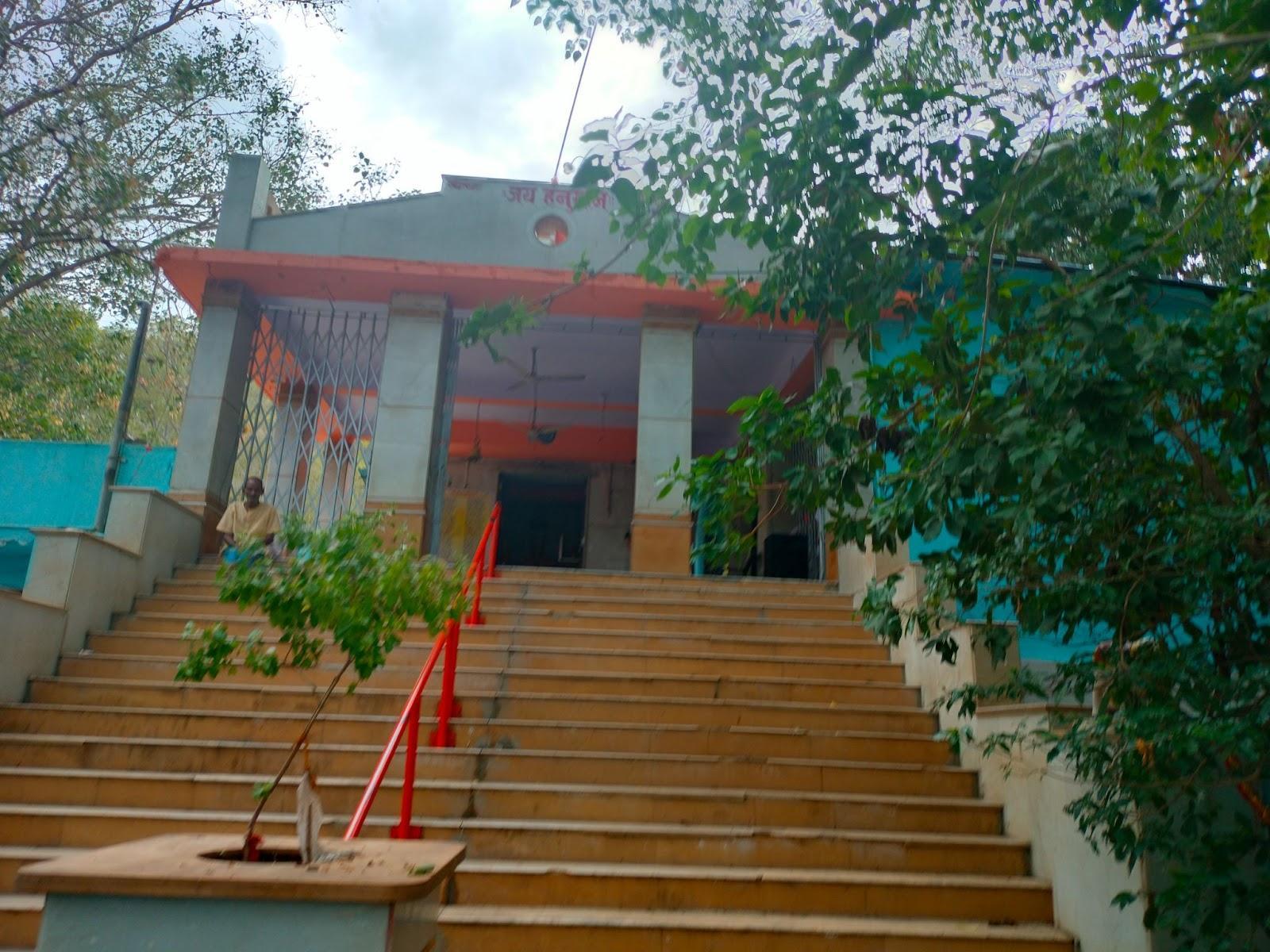
The mandir is particularly frequented on Mondays, a day considered auspicious for Hanuman worship. It remains accessible to the public and continues to function as an active religious site.
Jari Mari Mata Mandir
The Jari Mari Mata Mandir is located next to Bandra Lake, off S.V. Road in Mumbai. The murti is considered swayambhu (self-manifested) and is traditionally believed to have appeared in 1696, a date marked on a commemorative plaque at the site.
The image of the Devi is accompanied by seven asaras (spirits), a distinctive feature not commonly found in similar shrines. The Devi remains active and is visited regularly by worshippers from surrounding neighbourhoods.
Jhulelal Mandir
The Jhulelal Mandir, located in Mulund Colony, was established by members of the Sindhi Hindu community who arrived in Mumbai as refugees following the Partition of 1947. Originally dedicated to Jhulelal, the patron deity of the Sindhi community, the temple later came to house images of various deities, including Bhagwan Ram, Ganpati, and Shiv. At one time, it was also referred to as a “Shiv Mandir” by local residents.
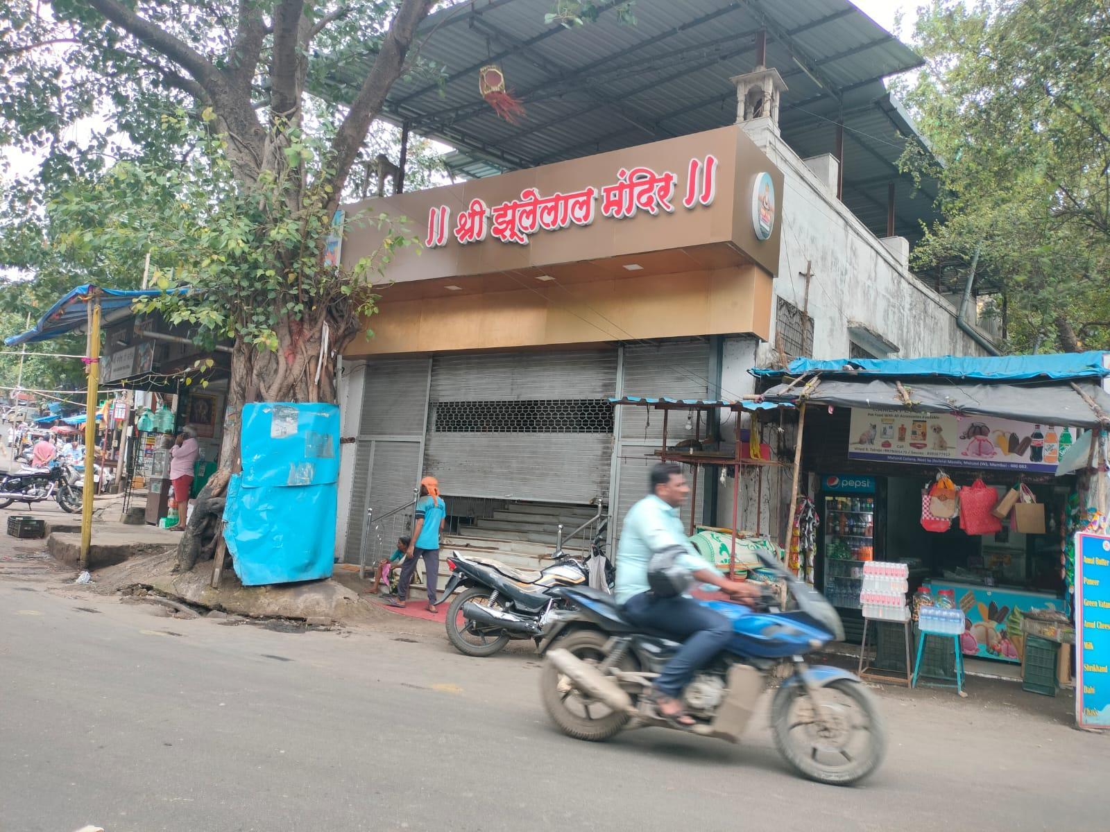
This syncretic character reflects the evolving nature of worship at the site, shaped by the broader community that gathered around it. The mandir remains a religious and social space for Sindhi families and nearby residents, with daily prayers held in the evening.
Jogeshwari Caves
The Jogeshwari Caves are a group of rock-cut monuments located in the suburb of Jogeshwari, Mumbai. Believed to date to the 6th century CE, they are among the earliest known examples of Hindu cave architecture in the Deccan region. The site was excavated into basalt rock and is considered an important early Shaiva monument, marking a transition in the region from Buddhist to Brahmanical patronage.
![Entrance to the Jogeshwari Caves complex, located within Jogeshwari, a densely populated suburb of Mumbai. The site is one of the earliest surviving Hindu rock-cut cave temples in India.[2]](/media/culture/images/maharashtra/mumbai-suburban/cultural-sites/entrance-to-the-jogeshwari-cav_cP3cPiC.png)
Historian Walter Spink has described the Jogeshwari Caves as the "grandfather of all" Hindu cave temples, noting their early date and their importance in shaping later rock-cut forms in the Deccan region. Along with the Elephanta Caves, Jogeshwari is frequently cited in studies of early Brahmanical cave architecture.
The caves are attributed during the rule of the Kalachuri dynasty (c. 550–620 CE),, who succeeded the Traitukas (c. 400–550 CE) and were patrons of the Pashupata Shaivite sect. Under Kalachuri patronage, a number of Shaiva shrines were established, with Jogeshwari among the earliest examples. The spread of Pashupata Shaivism in this period is often associated with Lakulisha, a religious teacher regarded by followers as an incarnation of Shiva. His teachings are believed to have influenced temple construction and devotional practices in the region.
The Jogeshwari complex includes a range of rock-cut spaces and sculptural panels, among them a depiction of the Sapta-matrikas (mother goddesses associated with Shiva). One of the devis in the panel, Yogeśwari Devi, lends her name to the site. According to historical texts such as the Bimbakhyāna (also referred to as Mahikāvatichi Bakhar), Yogeśwari was worshipped by regional rulers during times of political crisis. She continues to be venerated today as a kul-devi (family deity) by communities including the Pathare Prabhus and certain Gujarati migrant groups.
Despite its historical and religious significance, the site faces several conservation challenges. The caves are located in a densely populated area and are subject to urban encroachment, structural wear, and water leakage, which has contributed to the erosion of sculptural surfaces. These conditions have raised ongoing concerns regarding the long-term preservation of the monument.
The caves also remain an active site of worship, with daily pooja performed for Shiva, Ganesha, and Hanuman. This continued religious use coexists with its historical and archaeological importance.
The site is located approximately 1 km from Jogeshwari Railway Station and Jogeshwari East Metro Station, with access via the Jogeshwari-Vikhroli Link Road (JVLR). There is no formal signage, and access often relies on local guidance. The site is open to the public and does not require an entry fee.
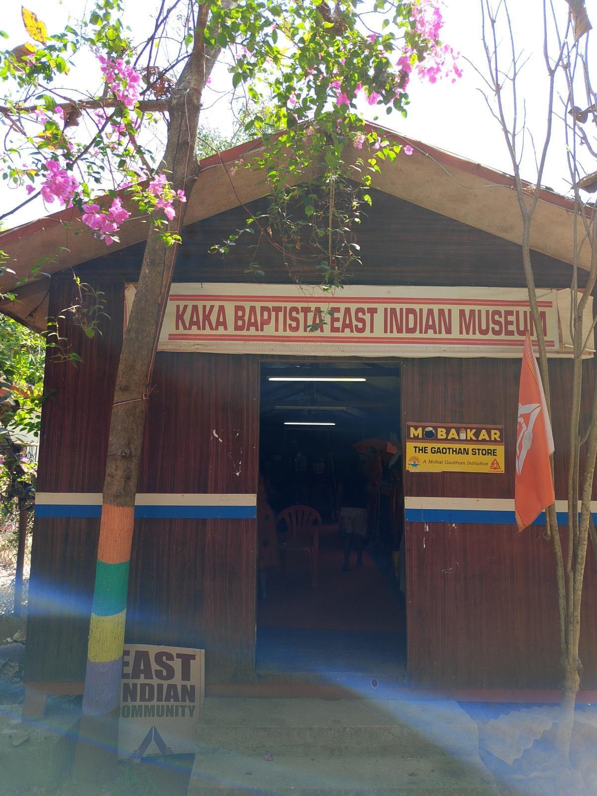
Kaka Baptista East Indian Museum
The Kaka Baptista East Indian Museum is located in Manori Gaothan, along the Manori–Gorai Road in Mumbai. It is dedicated to documenting the cultural history of the East Indian community, one of Mumbai’s oldest surviving communities.
Originally established as the East Indian Museum, it was renamed in 2011 in honour of Kaka Baptista, a local freedom fighter and political leader. The renaming was part of an effort to highlight his contributions, which many from the community feel remain largely absent from broader public commemorations. The museum was founded by Alphi D’Souza in collaboration with the Mobai Gaothan Panchayat, a community organisation engaged in preserving and bringing forth the voice of the community in public space.
The East Indians have lived in the region for over 400 years. They trace their ancestry to local agrarian groups who were converted to Roman Catholicism during the Portuguese colonial period (which lasted from early 16th to mid-18th century, c. 1510–1739). Their cultural practices reflect a mix of indigenous and colonial influences, shaped over generations of settlement in the Mumbai region.
Despite this long history, many members of the community have expressed a sense of alienation, particularly with regard to cultural recognition in the city. Alphi D’Souza articulating this sentiment says, “Although Mumbai is our homeland, not a single bhavan or cultural center has been created for us, while many other communities have had cultural spaces established in their honor.”
The museum, hence, began in two small huts, constructed through local initiative to do just that. These were later destroyed during a monsoon, but in 2013, a permanent structure was built in their place. The current space continues to function as a site for collecting, preserving, and sharing objects tied to East Indian domestic and cultural life.
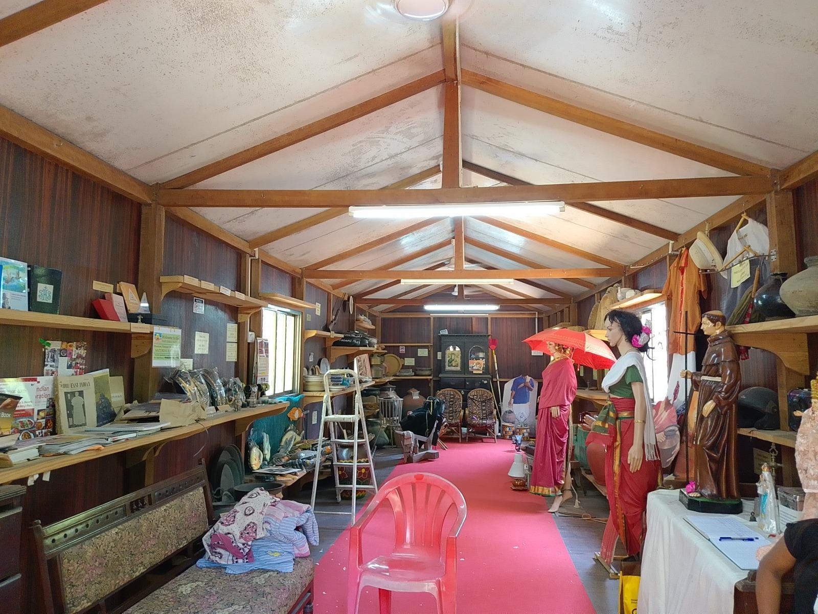
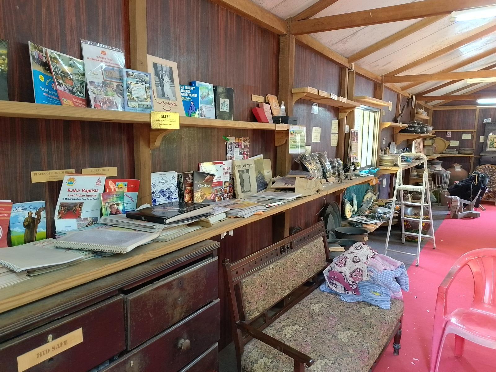
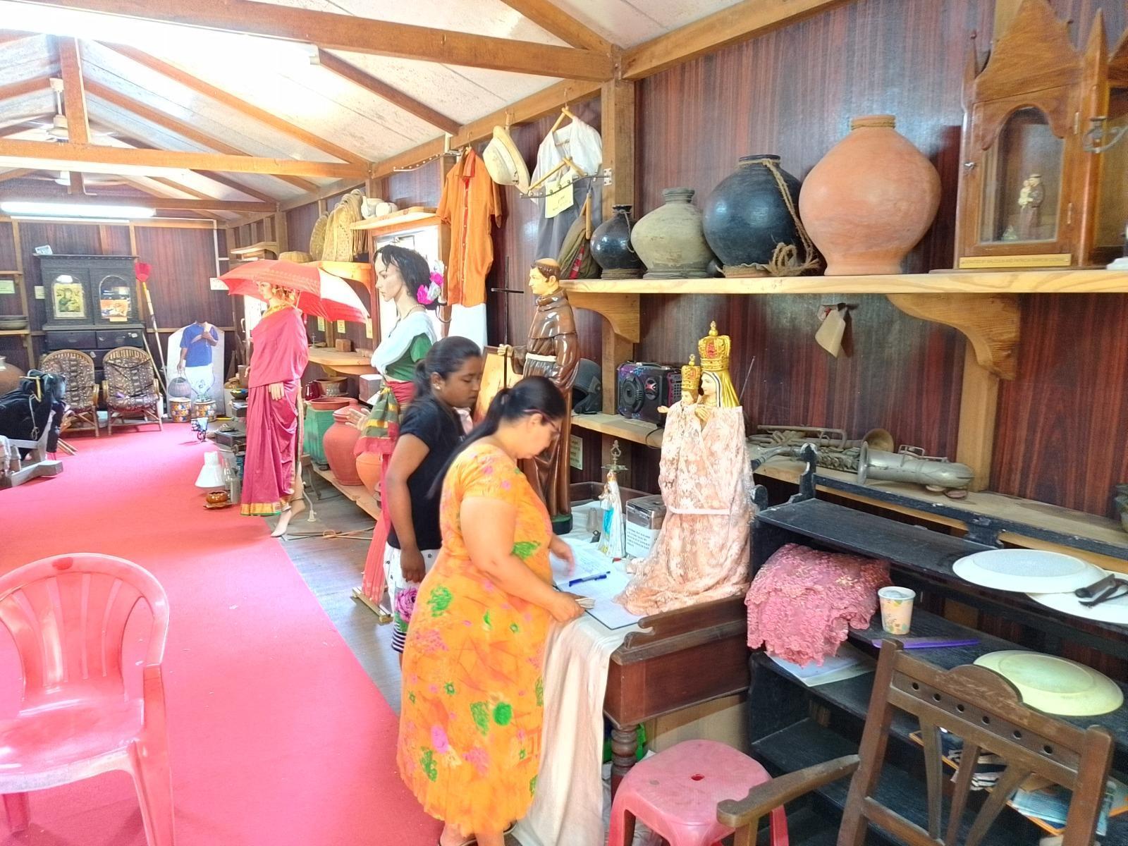
The exhibits include traditional utensils, clothing, tools, and other everyday materials, most of which have been donated by community members. There is also a collection of books, including dictionaries, cookbooks, and other texts written by East Indian authors. These materials offer insight into the linguistic, culinary, and literary histories of the community.
Each year, the museum organises East Indian Day, held in May on the Sunday following World Museum Day. The programme includes a mass, followed by cultural performances, and serves as a site for community engagement across generations.
While the museum has become a meaningful cultural site, it continues to operate without substantial institutional or governmental support. Members of the community have long voiced the need for greater recognition, and many still hope that the museum will receive the resources it needs to grow.
The museum is located in the coastal village of Manori, accessible by ferry from Marve Creek to the Manori Jetty. From there, visitors often take a tonga or rickshaw to the site. It can also be reached by road through Dahisar and Mira-Bhayandar, though this route is longer.
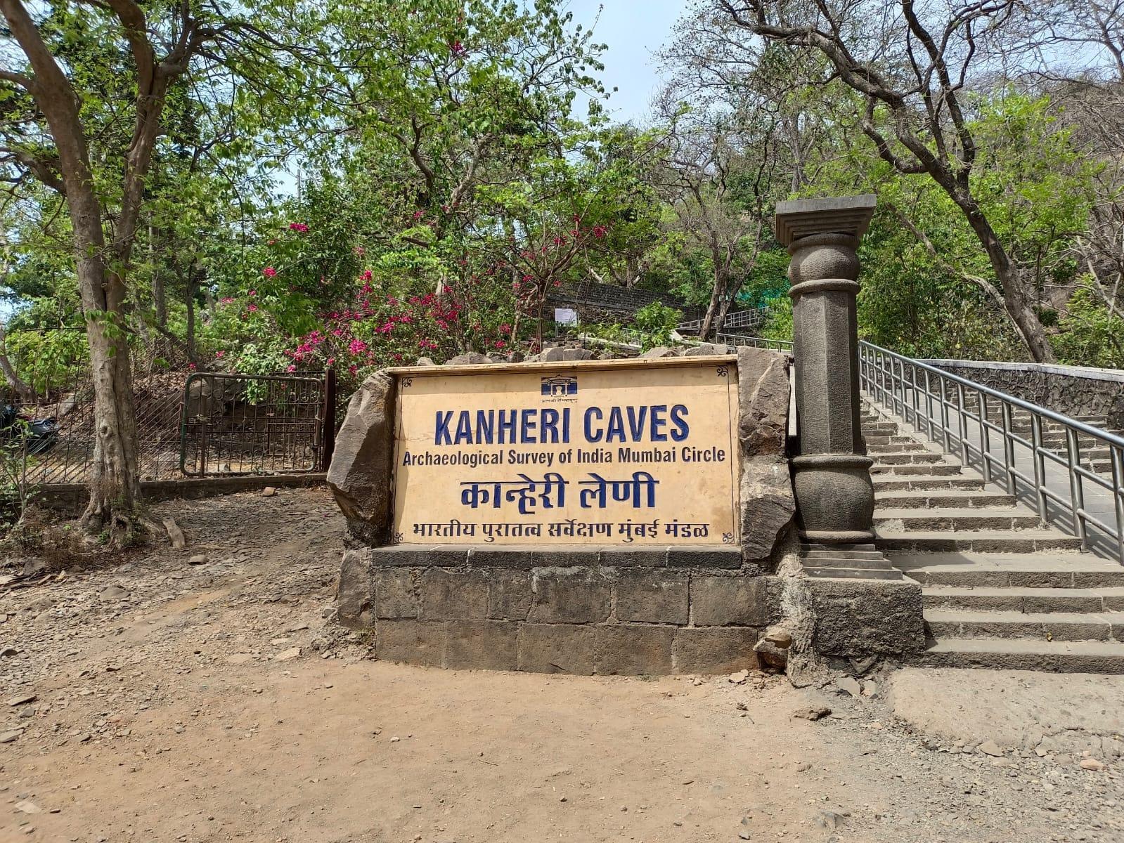
Kanheri Caves
The Kanheri Caves are a series of over 109 rock-cut monuments located within Sanjay Gandhi National Park in Borivali, Mumbai. These caves were carved into the basaltic hills of the region and served as a major Buddhist monastic center for over a millennium.The site is now a protected monument under the Archaeological Survey of India (ASI) and perhaps offers one of the most extensive records of Buddhism’s evolution in western India.
![Overview of the Kanheri Caves complex, carved into the basaltic hills of Sanjay Gandhi National Park, Borivali, Mumbai Suburban district. The site contains over 100 caves developed across more than a millennium.[3]](/media/culture/images/maharashtra/mumbai-suburban/cultural-sites/overview-of-the-kanheri-caves-_14EEYwA.png)
Historical Context
The rise of Buddhism in Maharashtra is generally associated with the Mauryan period, particularly the reign of Emperor Ashoka. As the religion spread, cave complexes began appearing along the western coast, often near trade routes and population centers. These sites, consisting of viharas (monastic cells) and chaityas (prayer halls), served the spiritual and daily needs of monks and lay communities.
Interestingly, Kanheri did not exist in isolation. It was part of a broader network of rock-cut sites across the modern suburban belt of Mumbai, including Mahakali (Kondivite), Mandapeshwar, Magathane, and Jogeshwari. The clustering of these sites, in many ways, reflects the long-standing cultural and religious significance of the region.
Interestingly, when talking about its origins, scholars often say that Kanheri's development may have been linked to the decline of the Sopara port in the 1st century CE. As Sopara’s role in coastal trade diminished, monastic communities likely shifted inland in search of more sustainable locations. Sites like Kanheri and Mahakali, situated near natural water sources and elevated terrain, offered suitable alternatives for continued religious life.
Development and Political History
The caves developed over several centuries, shaped by political transitions, economic changes, and religious patronage. As noted in the Documentation of Caves in MMR report, the site’s history is typically divided into three major phases.
The earliest phase, from the 2nd century BCE to the 4th century CE, is associated with the Satavahana dynasty. During this time, monks excavated simple viharas and chaityas for meditation and worship.
The classical phase, spanning the 5th to 11th centuries CE, saw the site expand under the Traikutaka rulers. This period introduced larger halls, more complex sculptural programs, and a significant number of inscriptions.
The final phase, from the 11th to 15th centuries CE, occurred under the Rashtrakutas and Shilaharas. While religious activity continued, it is noted that construction slowed, and the site gradually declined in prominence.
These shifts correspond to broader changes in the region’s political landscape, trade networks, and religious systems. Very remarkably, Kanheri’s longevity suggests it remained a stable religious and economic node across multiple regimes.
Inscriptions and Patronage
Kanheri’s longevity was supported by a wide and notably diverse set of patrons. Inscriptions carved into the cave walls provide detailed insights into the individuals and communities who contributed to the site over time. What is noteworthy is that many scholars regard the diversity of donors at Kanheri as a distinctive feature of the site. Its donors included kings, merchants, Brahmana and Shramana communities and very remarkably the merchant class and many women.
![Inscriptions in the ancient Bramhi script of the marriage of a South Indian king[4]](/media/culture/images/maharashtra/mumbai-suburban/cultural-sites/inscriptions-in-the-ancient-br_J4DqNED.jpg)
Interestingly, it is mentioned in Documentation of Caves in MMR that female donors appear frequently in earlier records, often listed with male relatives, though there are also independent references to nuns and wives of prominent individuals. Certain Satavahana kings were named after their mothers, suggesting the symbolic weight of maternal lineage in some dynasties.
Over time, however, it is noted that inscriptions referencing women became less common. This shift may reflect changes in legal structures, inheritance rights, or social norms that restricted women’s ability to make religious donations independently.
The caves also contain inscriptions in multiple scripts, including Brahmi, Pahlavi, and Japanese. A 10th-century Pahlavi inscription points to the presence of Parsi clerics, while carvings in Japanese script suggest contact with visitors from East Asia. The presence of these, in many ways, indicate that Kanheri was not only a religious center, but also a site of cultural exchange.
Architecture and Design
The caves were excavated from the basaltic rock typical of the Deccan plateau. Structures include monastic cells, pillared halls, chaityas, stupas, benches, and rest platforms. Interestingly, it is noted that the site shows a clear architectural progression, from plain, functional spaces in the early period to increasingly elaborate carved halls during the classical phase.
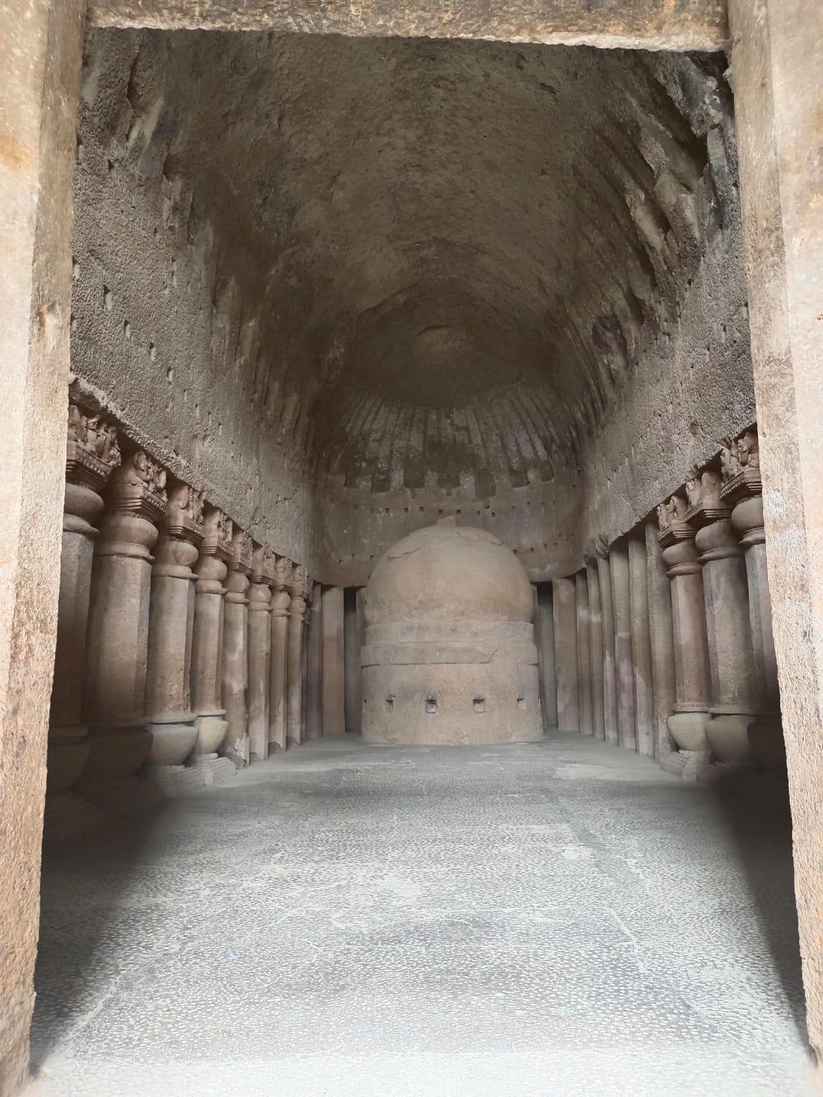
One of the earliest visual motifs at Kanheri is the depiction of the Buddha in robes and headgear, reflecting the evolving iconography of Buddhist art.
Aside from its historical and religious roles, Kanheri, for a long time, has held much importance for local indigenous communities of the district. Kanheri is regarded to be one of the seven sacred hills in their tradition. It is said that until approximately fifty years ago, the hilltop was used for rituals and worship by them. These practices, however, are believed to have come to an end following the site's designation as a protected archaeological site.
Lakshminarayan Mandir
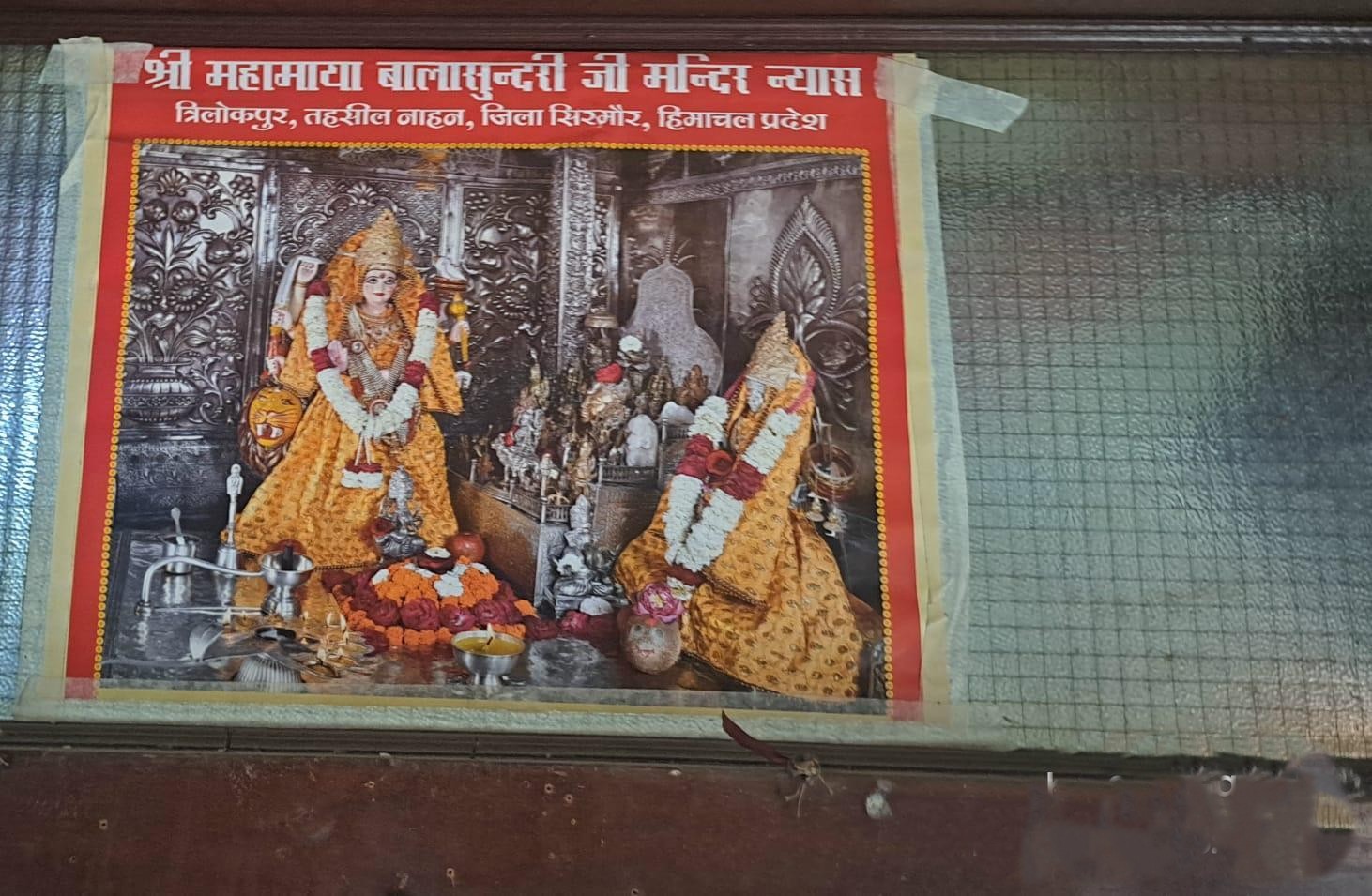
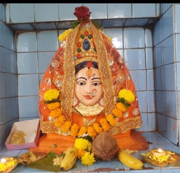
The Lakshminarayan Mandir is located in Agarwal Colony, Vashi Naka, Chembur, and was established in 1983. The mandir is privately managed by the Agarwal family, and has remained under their care for three generations. It is dedicated to Shri Mahamaya Balasundari Ji, the kul-devi of the family, a form of Durga worshipped primarily in Himachal Pradesh.
Magathane Caves
The Magathane Caves, located in Borivali East, Mumbai, were once part of a broader network of rock-cut Buddhist monuments in the Salsette region. While no visible remains survive today, historical inscriptions and archival documentation confirm the site's former presence and religious significance.
The most prominent reference to Magathane appears in an inscription from Cave 21 at Kanheri, which records a land donation from the village of Magathane by an individual named Aparenku of Kalyan. This inscription places Magathane within the larger economic and monastic networks of the early Buddhist period, suggesting that it was once an active and integrated site.
Archival records and photographs suggest that the site once contained Buddhist carvings, including stupas and relief sculptures, pointing to its former architectural and religious presence. Over the course of the 20th century, however, the site steadily deteriorated, not only due to natural erosion but through long-standing neglect and the accelerating pace of urban construction. As noted in the Documentation of Caves in MMR report, the remaining features were eventually lost, buried or broken under the pressure of real estate development and slum encroachment.
Between 2008 and 2010, heritage advocate Ashok Bhate led efforts to protect what remained, filing a petition to prevent further encroachment. Around the same time, archaeologist Prof. Anita Rane-Kothare presented a detailed account of the site's decline in her lecture Caves of Mumbai (2012). Drawing on archival images from the 1940s and early 2000s, she traced the extent of the damage, capturing the gradual disappearance of carvings, structures, and, ultimately, the site itself.
Today, the former location of the Magathane Caves lies beneath modern infrastructure along Dattapada Road, near the Western Express Highway, approximately one kilometre from Magathane Metro Station. The site is no longer accessible, and no visible remains survive. The loss of the Magathane Caves continues to be referenced in conversations around the preservation of Mumbai’s archaeological heritage in the face of urban development.
Mahakali Caves
The Mahakali Caves, also referred to as the Kondivite Caves, are a group of 19 rock-cut monuments located in Andheri East, Mumbai, near the old village of Kondivite. Situated on Veravali Hill, these caves were excavated between the 1st and 6th centuries CE, and are widely considered to have functioned as a satellite site to the Kanheri Caves.
A Pali inscription inside one of the caves records a donation by Pittimba, a Brahmin of the Gotama gotra, situating the site within the religious and social dynamics of early Buddhist patronage in the region (ASI).
![The main entrance path to the Mahakali Caves complex, Andheri, Mumbai Suburban. The site is protected by the Archaeological Survey of India (ASI) and remains accessible to the public despite its urban surroundings.[5]](/media/culture/images/maharashtra/mumbai-suburban/cultural-sites/the-main-entrance-path-to-the-_PxbI4xc.png)
Cave 9 is regarded to be the largest and most architecturally significant structure at the Mahakali site. It features a chaitya (prayer hall) with stupas and large Buddha sculptures, laid out as a rectangular hall with a circular inner chamber. This layout has been compared to the Sudama Cave in Barabar Hills, Bihar, one of the earliest known examples of rock-cut Buddhist architecture.
Interestingly, however, Cave 9 at Mahakali departs from this precedent in a significant way: its broad frontal opening allows natural light to enter and directly illuminate the stupa. As mentioned in the Documentation of Caves in MMR report, this seemingly small design change may point to larger shifts in architectural thinking, in the ways spaces were constructed or used, though its exact implications remain open to interpretation.
Besides its architectural features, the Mahakali Caves provide evidence of the region’s role in early trade and settlement networks. Madhavankutty Pillai in The Rock Chronicles (2023), the caves were likely located along a trade route connecting nearby settlements. Archaeologist Kurush F. Dalal (2021) similarly suggests that Mahakali formed part of a larger network of trade routes active during the 3rd and 4th centuries CE. These observations indicate that the area was integrated into broader patterns of movement and exchange well before the rise of Mumbai as a colonial port city.
Mandapeshwar Caves
The Mandapeshwar Caves, located in Borivali, Mumbai, are a group of ancient rock-cut monuments situated near the Dahisar River. Dating to the late 6th century CE, they are part of a group of early religious cave sites in the region, along with Jogeshwari, Mahakali, and Magathane. The site is protected by the Archaeological Survey of India (ASI).
The origins of the Mandapeshwar Caves remain debated. While the site is now known for its Shaiva iconography, some scholars suggest that the earliest excavations may have served as Buddhist viharas before being adapted for Hindu use.
![View of the rock-cut entrance at Mandapeshwar Caves, Borivali, Mumbai.[6]](/media/culture/images/maharashtra/mumbai-suburban/cultural-sites/view-of-the-rock-cut-entrance-_N2885pp.png)
The caves are situated near the ancient trade routes that once connected the coast with inland settlements. It is believed that Mandapeshwar may have served as a resting site for ascetics, pilgrims, and priests traveling to the nearby Kanheri Caves, which interestingly, some scholars believe, functioned as a major religious and educational centre at the time.
In the 16th century, during Portuguese rule, the Mandapeshwar Caves were converted into a Christian place of worship. The site was then, as mentioned in the Thane gazetteer (1882), incorporated into a church and college complex known as Montpezier (or Monpacer). Architectural modifications were made during this time, including the construction of masonry structures above the original rock-cut caves. Several of the earlier carvings were altered, defaced, or removed. A stone cross was carved into one of the cave walls and remains one of the few surviving features from this phase.
In 1739, following the Maratha conquest, the site was reclaimed and once again referred to as Mandapeshwar. A Marathi inscription in Devanagari script was added to mark this moment. The use of the site during this period reoriented it once again toward Shaiva pooja. During the subsequent British colonial period, the site remained under Christian use, though the nature and extent of its religious use during this time are unclear.The shifting religious and political uses of the site have led many to regard Mandapeshwar as “perhaps [having] the most tumultuous history of all the Mumbai caves.”
Compared to sites such as Kanheri and Mahakali, the Mandapeshwar Caves exhibit more extensive deterioration. Notably, the site continues to be recognized for its cultural and religious importance. Today, the caves continue to function as an active Shiva shrine and draw devotees during festivals such as Mahashivratri and Kartika Poornima.
Nama Devi Mandir
The Nama Devi Mandir is located in the forested area of Amar Nagar, Mulund (West). According to oral accounts, the murti was originally found between rocks near a mud well, and gradually became a site of regular worship. The area is frequented by residents from nearby neighbourhoods other than Amar Nagar, such as Bhandup Koliwada and Old Barracks Street in Mulund (W).
The mandir has many stories attached to it, however it fascinatingly still remains as a site of mystery. According to local accounts, the murti of Nama Devi was discovered between large rocks near a mud well, where worship gradually began. The site became a regular place of devotion for residents of nearby settlements. Very remarkably, Nama Devi is perceived by her followers in multiple ways, as a van-devi (forest goddess), kul-devi (family deity), and in some narratives, as a form of Kaali Maa.
The Nama Devi Mandir continues to hold a meaningful place for residents of the region, many of whom trace their connections to the site across generations. It has been maintained over time by families from diverse communities, including the Kolis, Warlis, and partition-era refugee families, each contributing to the shrine’s ongoing care and ritual life.
Interestingly, in his research on Bhandup Koliwada, Anurag notes that the mandir historically marked the western boundary of the Koliwada. This suggests the site may have once served both a spiritual and spatial function within a broader network of shrines maintained by Mumbai’s Koli community, who are among the city’s oldest inhabitants.
Despite its remote location, the mandir remains active. On Buddha Poornima in 2024, local residents said that 3,000 devotees visited the site, indicating the site’s ongoing role in contemporary religious life.
To reach the mandir, visitors typically take the A-391 bus (Khindipada Dargah) from Mulund Station. The entrance lies between the forest department office and a nearby dargah, from where the trail to the shrine begins.
Oratory of Our Lady of Fatima
The Oratory of Our Lady of Fatima is located on the western slope opposite the Mount Mary Basilica in Bandra, Mumbai. It was constructed in 1954 as a memorial to the Marian Congress held in Bombay from 4 to 8 December 1954. The oratory was commissioned by Msgr. Placidus Edward (Eddie) Fernandes.
The site is dedicated to Our Lady of Fátima, a Catholic title of Mary, mother of Jesus, based on apparitions believed to have occurred in 1917 in Fátima, Portugal, where three shepherd children described visions of the Virgin Mary.
In the evenings, the shrine is softly illuminated by wax offerings, which can often be seen glowing from a distance.
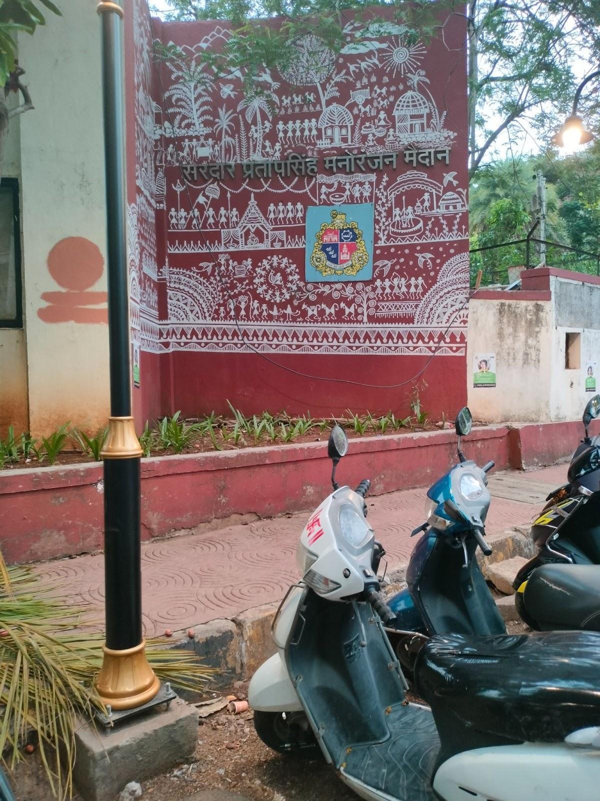
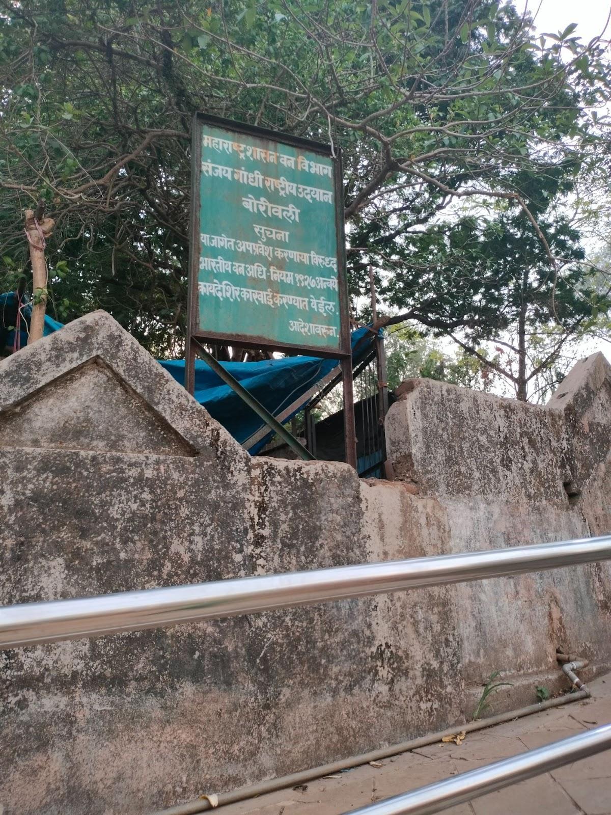
Sanjay Gandhi National Park (Mulund Entrance)
Sanjay Gandhi National Park (SGNP), one of Mumbai’s largest green spaces, extends across both eastern and western suburbs. While its main entrance is located in Borivali, an alternative access point exists in Mulund Colony, through a park known as Sardar Pratap Singh Manoranjan Maidaan.
Previously named Sardar Tara Singh Garden, this area was renamed to honour Sardar Pratap Singh, a freedom fighter and father of local politician Sardar Tara Singh, who played a key role in the garden’s development. Today, it functions as an eastern threshold to SGNP and is situated adjacent to the Yogi Hills range.
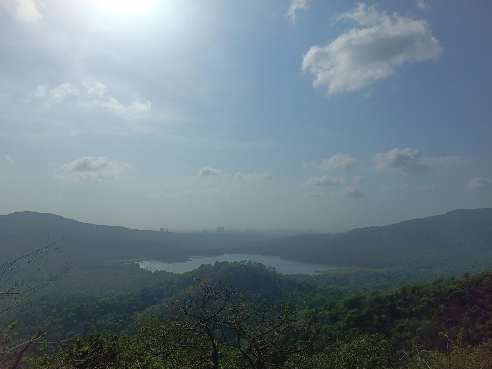
The region forms part of a larger mountainous and forested landscape, marked by three locally known hilltops often referred to as the “tops” of Mulund Colony. The first hill features a small waterfall that flows during the rainy season, while the third offers views of Tulsi and Vihar Lakes. These two lakes are part of seven that provide fresh water to Mumbai, incorporated into the British water supply plans of the 19 century.
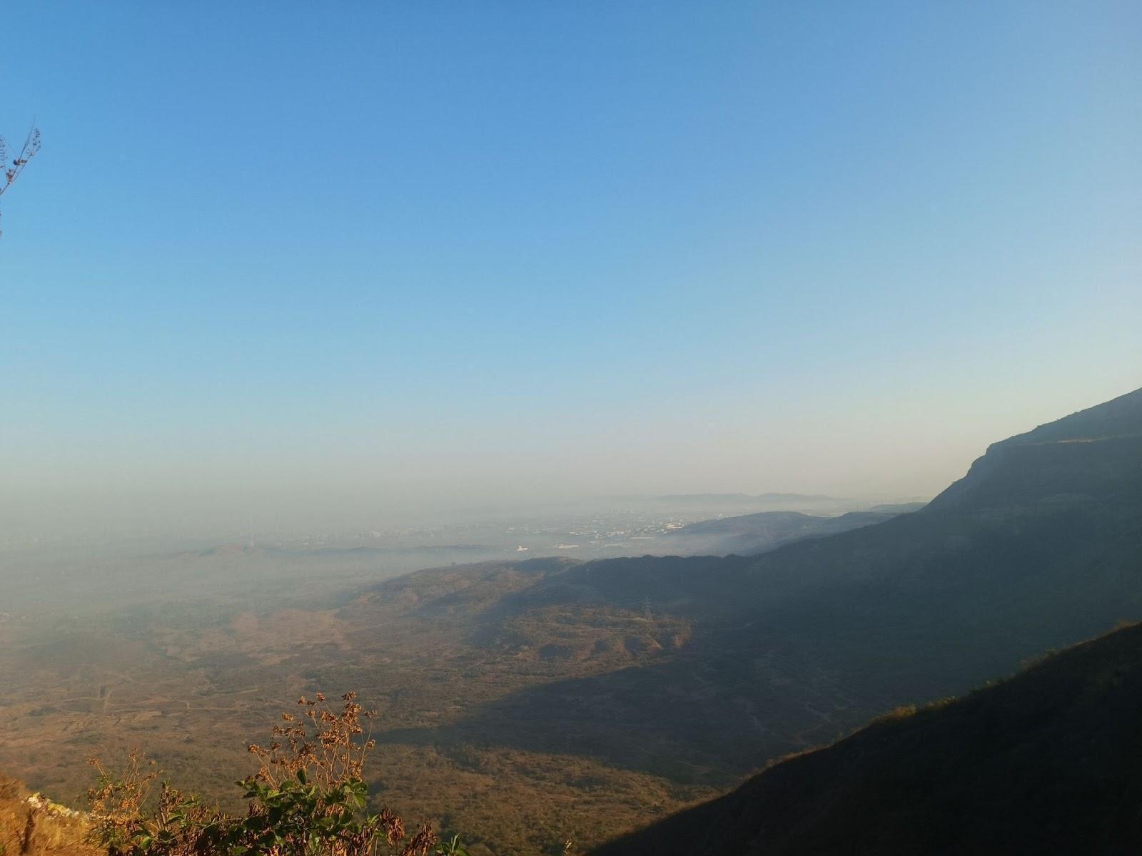
Trekking in this area has been common for over sixty years. Local residents recall that weekend mornings often saw groups climbing the peaks, while weekdays were quieter. The trail network connects into the Thane region and has historically been used for both recreation and worship. Trekking groups would commence their journeys at 6 am, traveling in groups being a safety measure that was believed to bar attacks from wild animals - a safety in numbers concept; the trek time would usually take from 30 minutes to 1 hour.
The Sardar Tara Singh Park was established around 2006 and the trekking tradition became more popular after that. However, locals say that access to the forest was restricted after a tragic incident where a regular trekker was attacked by a leopard. Forest rangers were then stationed in the area, and during quarantine, access to the mountains was completely shut down. Although it has since reopened, trekking now requires membership, and access to the third peak is strictly prohibited for trekkers.
While these regulations were initially enforced following quarantine, locals say that a significant issue today is the lack of forest rangers, guards, or clear informational signage about the rules. Sudden inspections by the forest department have become common, resulting in fines ranging from 1,000 to 2,000 rupees imposed unexpectedly.
While access to this part of the park is now restricted, the third peak of the eastern entrance remains notable for reasons beyond its terrain. At its summit stands a small and somewhat enigmatic shrine: the Taramati Mandir. Though modest in structure, the mandir has attracted local curiosity for years, with multiple interpretations about its origins. Some believe it has existed for generations as part of the natural landscape; others suggest it was built by trekkers who frequented the hill before restrictions were imposed.
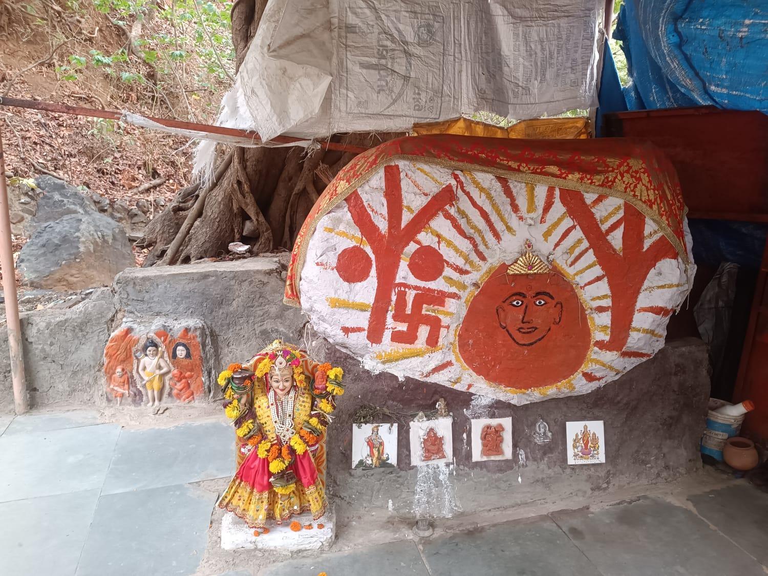
Over time, the shrine has accumulated a range of devotional items, murtis, framed photos, and carvings of various devis, devtas, and Sai Baba. These additions reflect an evolving pattern of local worship and the site’s integration into contemporary religious life.
The most visually distinctive feature is the image of Taramati Devi herself, shown surrounded by rays of light and tree branches. The imagery suggests a symbolic fusion of the divine with the natural world, a theme which is very pantheistic in its nature.
Interestingly, archaeologist and historian Kurush Dalal (2017) has offered a theory about the name “Taramati.” He proposes that it may be a linguistic remnant of the Buddhist goddess Tara, pointing to its uncommon usage in regional traditions. He corroborates this based on the proximity of this route to the old path leading to the Kanheri Caves, once a major Buddhist monastic centre. According to Dalal, such a connection, if true, may indicate a deeper, older religious layer beneath the current form of worship.
Today, the murti of Taramati at the shrine differs from the one originally worshipped by earlier devotees. The original murti is believed to now reside in Ghatipada, Mulund, where worship continues at the Tara Devi Mandir. The connection between these two sites, Ghatipada and the third peak, is interpreted by some as evidence of continued worship, though the form and setting of that worship have shifted over time.
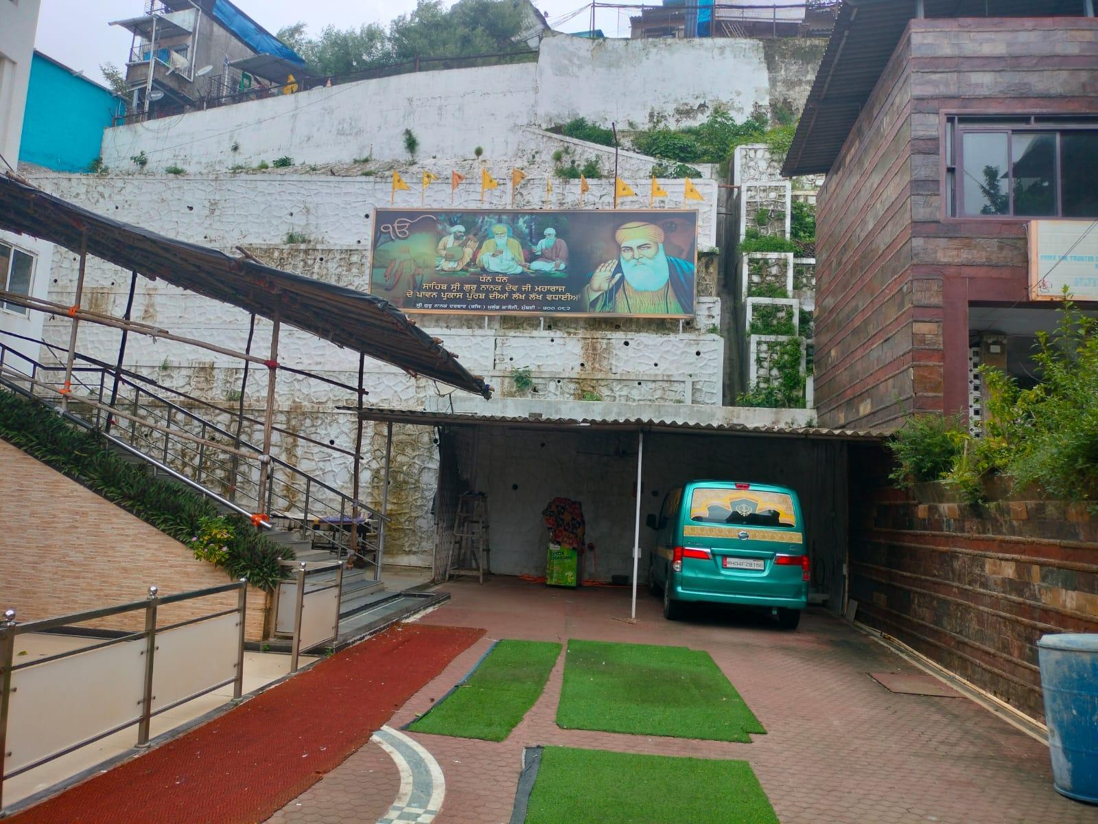
Sri Guru Nanak Darbar
The Sri Guru Nanak Darbar is regarded to be among the oldest and one of the largest gurdwara in Mulund, Mumbai. It was established in 1952 by Sikh families who had settled in the area following the Partition of India. Many of these families were among the refugees relocated to the military barracks in the hilly terrain of Mulund West, a region that became home to several displaced communities.
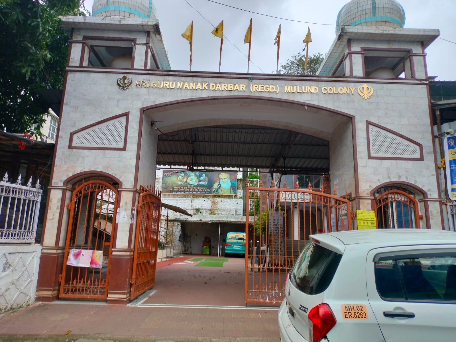
The gurdwara serves as a religious and cultural centre for the Sikh population of Mulund and nearby areas. Weekly practices include the langar, a communal meal prepared and served every Sunday, rooted in the Sikh principles of seva (selfless service) and equality. Major Sikh festivals, including Guru Nanak Jayanti, Guru Gobind Singh Jayanti, and Baisakhi, are celebrated annually.
The Sukhmani Sahib Path is held on Wednesdays, primarily led by women. Entry to the gurdwara is open to all, with head coverings required as per customary practice. Signage within the gurdwara includes instructions written in Gurmukhi script.
Tara Devi Mandir
Tara Devi Mandir is a shrine located in Ghatipada, Mulund, and is considered by local residents to be the graam devta (village deity) of the area. The murti is believed to be swayambhu (self-manifested) and was originally worshipped on the third peak of Sanjay Gandhi National Park. It was relocated to its current site in the 1980s or 1990s to make it more accessible to devotees who found the mountain climb increasingly difficult.
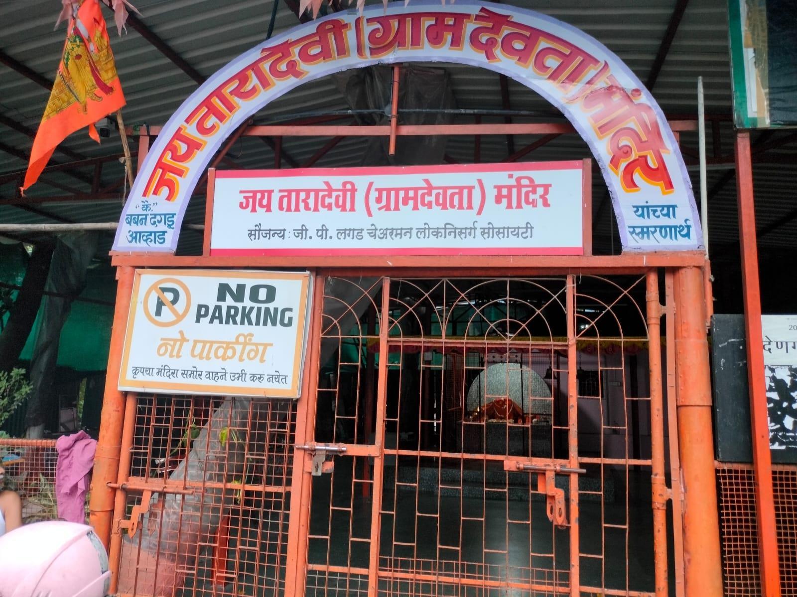
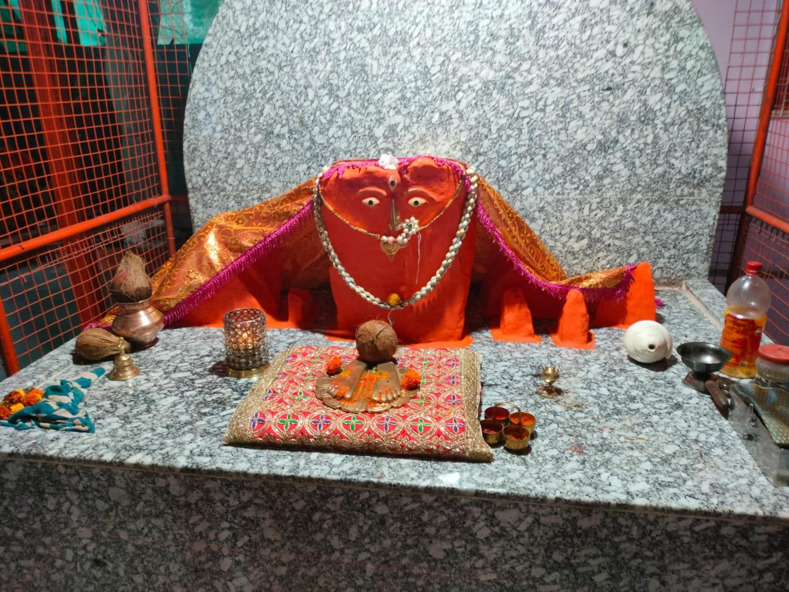
The shrine is surrounded by a series of six hill-like formations, which some interpret as symbolising a connection between the devi and the surrounding landscape. The mandir does not have an appointed priest or pujari. Instead, worship is maintained by the local community, who organise annual events including Hanuman Jayanti, poojas, and bhandaras (community feasts).
The murti has been identified by a scholar as a possible gadhegal (also known as an ass-curse stone), a medieval land grant marker commonly used during the Shilahara dynasty. Gadhegals typically consist of three carved panels. The topmost section often features the sun and moon, representing eternal tenure of the granted land. While much of the surface is covered with vermillion, traces of the crescent and circular motifs are faintly visible at the top of the murti, suggesting such a symbolic origin. If true, the identification may suggest that Mulund’s historical significance extends further back than commonly assumed.
Veergal/Eksar Hero Stones
The Eksar Veergals, located in Eksar village, Borivali, are a group of carved memorial stones believed to date back to the Shilahara period (c. 9th to 13th century CE). These stones form part of a wider memorial tradition found across Maharashtra and parts of South India, in which Veergals, or hero stones, were erected to commemorate individuals who died in battle or while defending their community.
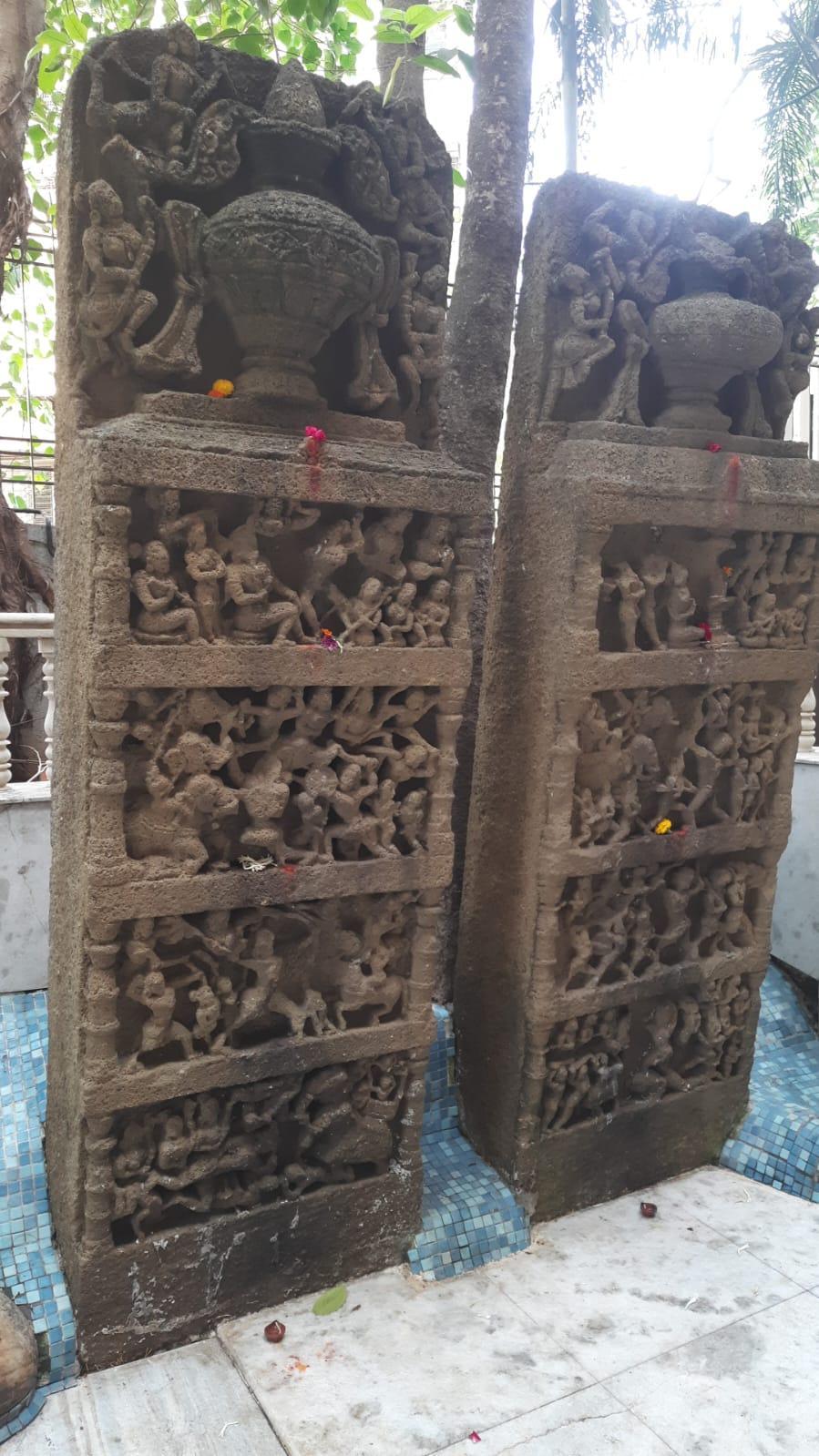
Artistically, a Veergal typically follows a three-panel format. The top panel often features a jar or pot, representing amrit (the nectar of immortality). The middle panel usually depicts the warrior worshipping a deity or ascending into the afterlife. The bottom panel contains the main narrative scene illustrating the battle in which the hero was killed.
In the case of Eksar, these stones are considered unusual within this broader tradition. Instead of portraying land-based conflicts, which they usually do, the Eksar Veergals depict naval battle scenes. Carvings include ships, warriors, and marine combat, suggesting that the commemorated individuals may have died in coastal or maritime engagements likely during the reign of the Shilaharas.
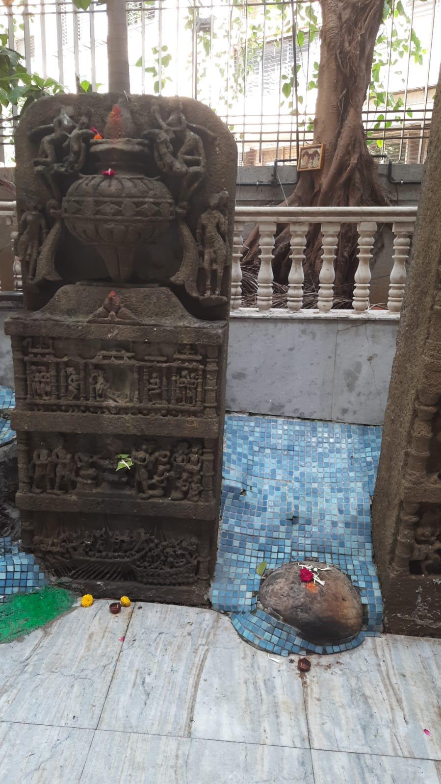
Aarefa Johari (2012) commenting on the Eksar Veergal writes, “these war memorials, made of flat basalt tablets ranging from four to eight feet in height, are an unusual and significant representation of maritime heritage within the broader tradition of hero stones.” They are, in many ways, considered to be rare within the archaeological record of hero stones in Maharashtra.
Very remarkably, in recent times, the Eksar Veergals have come to be included in local religious practice. Members of the Koli community associate the stones with Ekvira Devi and also with Satera Aai, a figure venerated in the surrounding region. Their continued presence in the landscape reflects a form of continuity, even as their meaning and function have shifted over time.
Sources
Aarefa Johari. 2012. Outcast in Stone. Hindustan Times. Accessed March 25, 2025.https://www.hindustantimes.com/mumbai/outcas…
Anurag. Bhandup Koliwada. Jio Institute Digital Library. Accessed March 25, 2025.https://exhibits.jioinstitute.edu.in/spotlig…
Archaeological Survey of India (ASI). List of Protected Monuments in Mumbai Circle, District-wise. ASI Mumbai Circle.https://web.archive.org/web/20130606093840/h…
Ashutosh Bijoor. 2013. Mandapeshwar Caves, Borivali: Legacy of a Tumultuous Past. Bijoor. Accessed March 25, 2025.https://bijoor.me/2013/09/08/mandapeshwar-ca…
Department of Ancient Indian Culture, Sathaye College. Documentation of Caves in MMR. MMRHCS. Accessed March 25, 2025.http://www.mmrhcs.org.in/images/documents/pr…
Heritage Chronicles. 2010. Caves, Temples, Churches and Remnants of the past - Heritage walk in suburb named after sweet berries - Borivali. Accessed March 25, 2025.https://heritagechronicles.blogspot.com/2019…
Hindustan Times. 2010. Magathane Caves Could Be Lost. Hindustan Times. Accessed March 25, 2025.https://www.ldeo.columbia.edu/edu/eesj/gradp…
Khaki Lab Mumbai. 2023. Gadhegals Of Maharashtra By Harshada Wirkud. YouTube. Accessed March 25, 2025.https://www.youtube.com/watch?v=W7bLQ2NeXEg
Maharashtra State Gazetteers. 1882 (reprinted in 2000).Thana District. Directorate of Government Printing, Stationary & Publications, Government of Maharashtra, Mumbai.
Mount Mary Basilica. Oratory. Mount Mary Basilica, Bandra. Accessed on 25 March 2025.https://www.mountmarybasilicabandra.in/orato…
Mrityunjay Bose. 2022. Mandapeshwar: Equally Important for Buddhists, Hindus, and Christians. Deccan Herald. Accessed on 25 March 2025.https://www.deccanherald.com/india/mandapesh…
ORF Mumbai. 2012.Caves of Mumbai. YouTube. Accessed March 25, 2025.https://www.youtube.com/watch?v=sTH-FnHfR7U&…
Owen Kail. 1984. Elephanta: The Island of Mystery. Taraporevala. Page 21.https://books.google.com/books?id=ylweAAAAMA…
Pillai, Madhavankutty. 2023. The Rock Chronicles. Open the Magazine. Accessed March 25, 2025.https://openthemagazine.com/author/madhavank…
Rachel Lopez. 2021. The Beginnings of Bombay: Tracing a Portuguese Legacy. Hindustan Times. Accessed March 25, 2025.https://www.hindustantimes.com/lifestyle/art…
Samir S. Patel. 2007. The Slum and the Sacred Cave. Archaeology. 29-44. https://www.ldeo.columbia.edu/edu/eesj/gradp…
Suraj Pandit. 2010. Water Management System at Kanheri. Journal of Asiatic Society of Mumbai. Academia.edu. Accessed March 25, 2025.https://www.academia.edu/2624271/Water_Manag…
The Loft Forumi. 2017. Talk with Dr. Kurush Dalal: Archaeologist. YouTube. Accessed March 25, 2025.https://youtu.be/ELo9sanUV5o?si=nn67fDKMOkZk…
Theory9. History of Mount Mary Church, Bandra.Theory9. Accessed March 25, 2025.https://www.theory9.in/blog/history-of-mount…
Last updated on 6 November 2025. Help us improve the information on this page by clicking on suggest edits or writing to us.