Amravati
12210 sq km.
~31.29 lakh (2019)
947 (2011)
~ ₹36,444 crore (2019)
~ ₹1.16 lakh (2019)
Amravati district is located in the north of Maharashtra, and has boundaries with Betul and Chhindwara districts of Madhya Pradesh state to the north of it. Archaeological evidence of human presence in Amravati from the 11th century includes a marble statue of the Jain tirthankara Rishabhanatha, which was installed in 1097 as per its inscribed base. In the 13th century, when Govind Maha Prabhu visited, the area around Amravati was under the rule of the Hindu Yadav king of Devagiri. In 1722, Chhatrapati Shahu Maharaj granted Amravati and Badnera to Shri Ranoji Bhosle, after which the city, then known as Bhosle ki Amravati, was rebuilt and flourished under his leadership following the treaties of Devgaon and Anjangaon Surji and the successful capture of Gavilgad Fort in Chikhaldara. In 1853, the region of Berar (which Amravati was part of) came under British. Once under British administration, Berar was split into two districts, with Amravati’s lands included in North Berar, headquartered at Buldhana. Later, the district became part of East Berar, with Amravati as its headquarters. Over time, Yavatmal and Ellichpur districts were separated, but Ellichpur was later merged back. By 1903, the region was incorporated into the Central Provinces and Berar. After India’s independence and reorganization, Amravati was included in Bombay State in 1956, and then became part of Maharashtra after the state's formation in 1960.
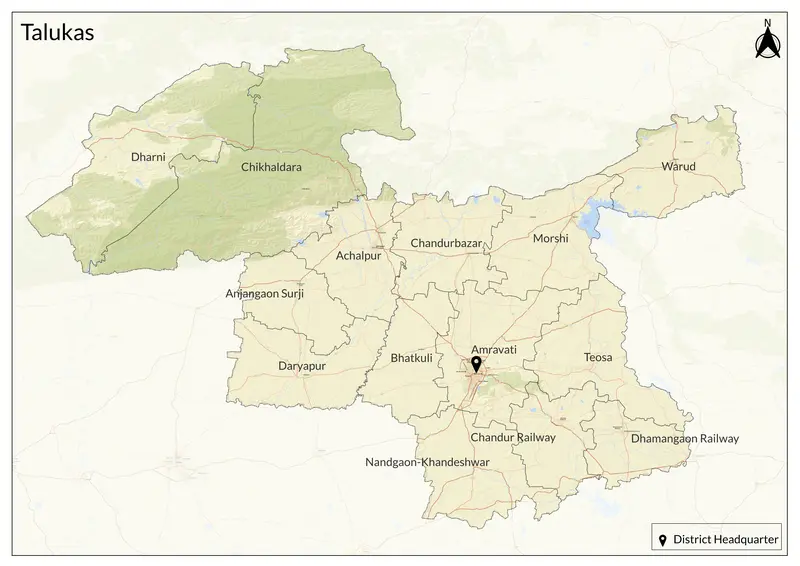
Today, it includes 14 talukas, namely Amravati, Achalpur, Warud, Morshi, Daryapur, Anjangaon Surji, Chandurbazar, Dharni, Chikhaldara, Dhamangaon Railway, Nandgaon-Khandeshwar, Bhatkuli, Teosa, and Chandur Railway. The main language spoken is Marathi, with Hindi and Urdu also widely understood.
Amravati's name has an interesting historical evolution. Its ancient name was "Udumbravati" (in Prakrit, it becomes Umbravati) due to the abundance of "Audumbar" (Fig) trees in the region. Over time, this name gradually transformed into "Amravati" due to linguistic adaptations and pronunciation changes. The name also translates to "the abode of immortals" and is linked to Krishna and Ambadevi.
Historically, Amravati was part of the Vidarbha Kingdom and later ruled by the Vakatakas, Chalukyas, and Rashtrakutas. During the Mughal and Maratha periods, it gained strategic importance. Key historical sites include the Ambadevi Mandir and the Gawilgarh Fort, known for its Mughal and Maratha architecture.
Amravati is located on the Deccan Plateau, about 340 meters above sea level, surrounded by the Satpura Range. The Wardha River marks the eastern boundary of the district, with the eastern region lying within its watershed. The southwestern part of the district is drained by the Purna River, while the northwest is served by the Tapti River. Other significant rivers include the Shahanoor and Chandrabhaga. It has a tropical wet and dry climate, affecting local agriculture. The Melghat Tiger Reserve adds ecological importance to the region.
The economy is primarily agricultural, producing oranges, pulses, and oilseeds, supporting textile industries and agro-processing units. Cotton, tur are prominent produce, as well as paan (betel leaves), banana and soybean. Local markets like Gandhi Chowk and Shivaji Market are key commercial hubs. Additionally, Musali and cherry cultivation has been successfully introduced in the Chikhaldara Hills.
Explore Amravati