Contents
- Physical Features and Boundaries
- Climate
- Geology
- Soil
- Minerals
- Rivers
- Botany
- Wild Animals
- Birds
- Fishes
- Forest Reserves
- Katepurna Wildlife Sanctuary
- Land Use
- Environmental Concerns
- Deforestation
- Water Scarcity
- Air Pollution
- Climate Change Vulnerability
- Conservation Efforts
- Biogas Rediscovered
- Graphs
- Water
- A. Rainfall (Yearly)
- B. Rainfall (Monthly)
- C. No. of Rainy Days in the Year (Taluka-wise)
- D. Evapotranspiration Potential vs Actual Numbers (Yearly)
- E. Annual Runoff
- F. Runoff (Monthly)
- G. Water Deficit (Yearly)
- H. Water Deficit (Monthly)
- I. Soil Moisture (Yearly)
- J. Seasonal Groundwater Levels: Bore Wells
- K. Seasonal Groundwater Levels: Dug Wells
- Climate & Atmosphere
- A. Maximum Temperature (Yearly)
- B. Maximum Temperature (Monthly)
- C. Minimum Temperature (Yearly)
- D. Minimum Temperature (Monthly)
- E. Wind Speed (Yearly)
- F. Wind Speed (Monthly)
- G. Relative Humidity
- Forests & Ecology
- A. Forest Area
- B. Forest Area (Filter by Density)
- C. Wildlife Projects (Area and Expenses)
- Human Footprint
- A. Nighttime Lights
- Sources
AKOLA
Environment
Last updated on 6 November 2025. Help us improve the information on this page by clicking on suggest edits or writing to us.
Akola district, situated in Maharashtra's Vidarbha region, features a diverse environment that includes agricultural landscapes, small forest patches, and water bodies such as the Morna River. This district is home to a variety of flora and fauna, although biodiversity has been adversely affected by deforestation and habitat loss. Renowned for its black soil, Akola is particularly well-suited for cotton cultivation.
Physical Features and Boundaries
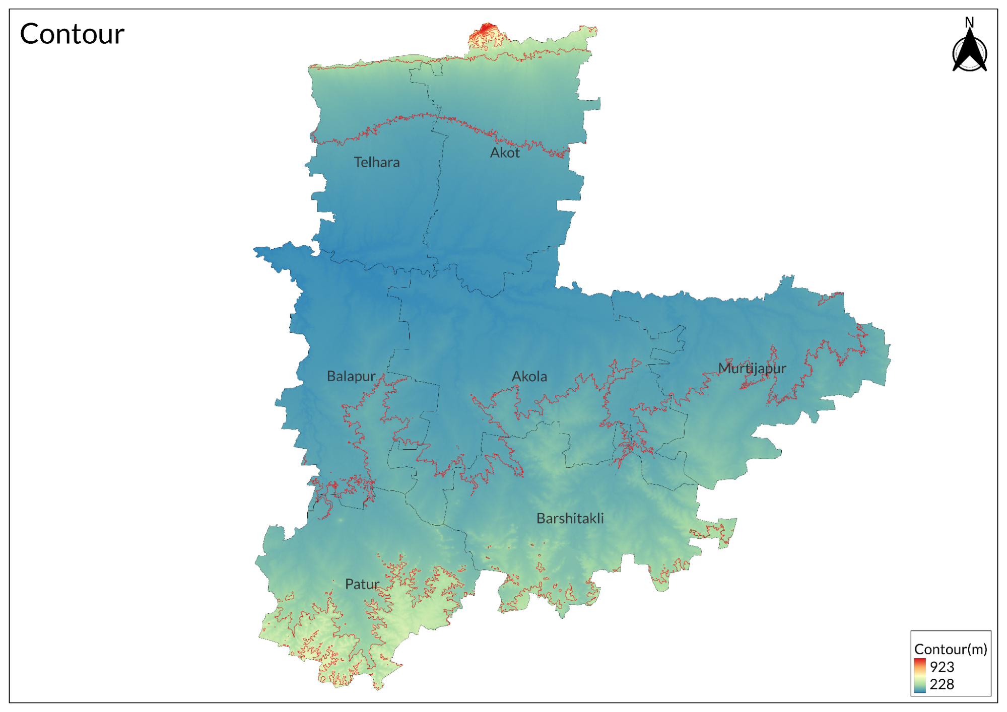
Aloka district is located in the central part of the Amravati region in Maharashtra, situated at an average elevation of 304 m and covering an area of 5,428 sq. km. It is bounded by Amravati to the east and north, Washim to the south, and Buldhana to the west, and is divided into seven tehsils.
The Satpura range borders the district to the north, sloping towards the south. The northern hilly region is part of the Satpura range, which lies above 400 m above mean sea level. The ruins of Narnala Fort, built in the 10th century by the Gond king, are located at the southernmost tip of the Satpura range at an elevation of 3161 feet (912 m) above mean sea level. Other prominent hills in the district include Buddha Hill and Balapur Hill, known for Balapur Fort.
The central part of the district is predominantly flat, while the southern part is elevated with a general slope towards the north. The central region, primarily composed of alluvial deposits, has a gentle slope and ranges between 200 to 260 m above mean sea level. The southern areas of Barshi Takli and Patur form a plateau region with elevations ranging from 400 to 450 m above mean sea level. Purna is the major river in the district, flowing from east to west through its central region.
Climate
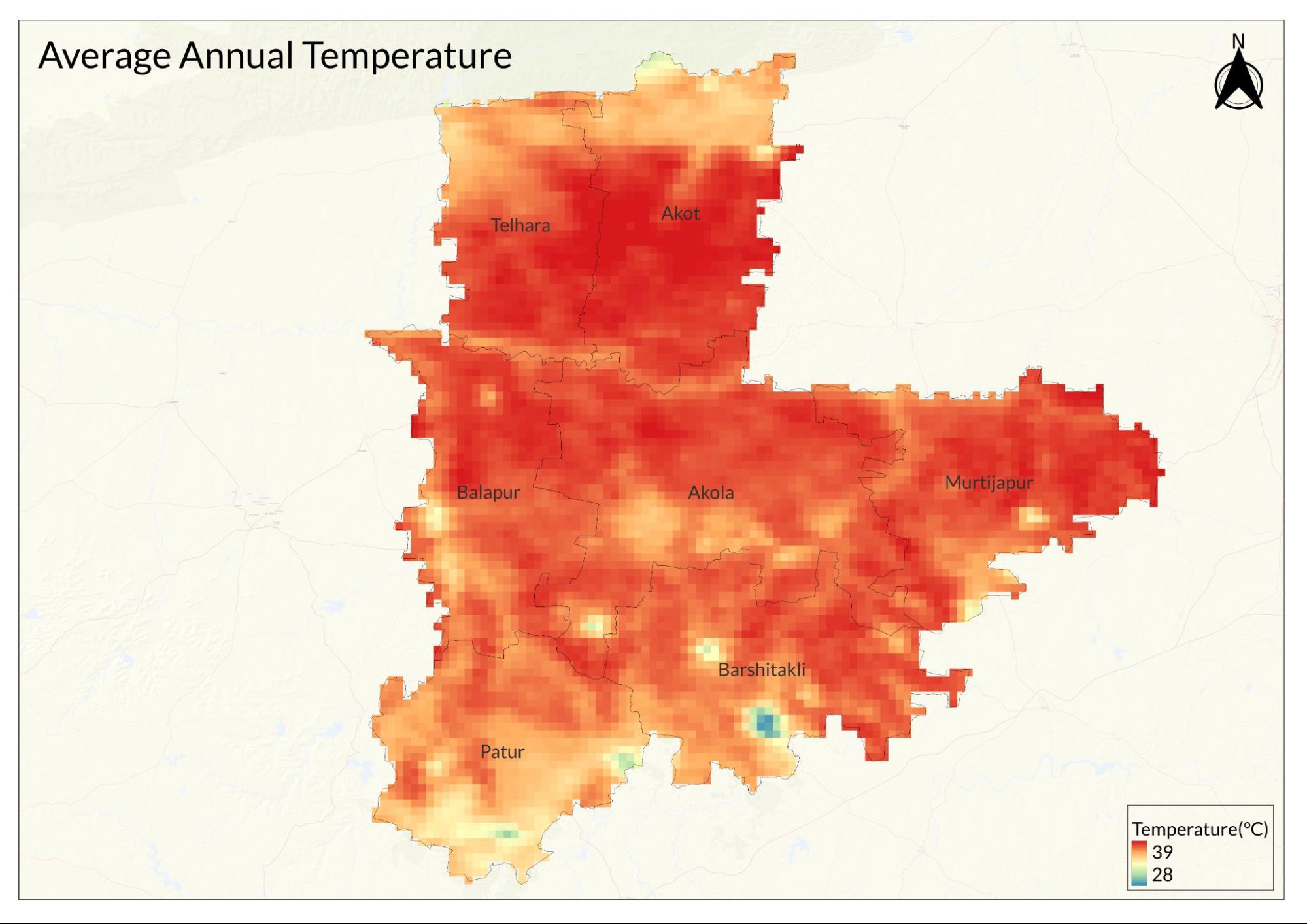
Akola district has tropical wet and dry weather throughout the year with an average temperature between 24ºC to 34ºC. The summer season in Akola extends from March to June, with May being the hottest month, where average temperatures soar to 42ºC.
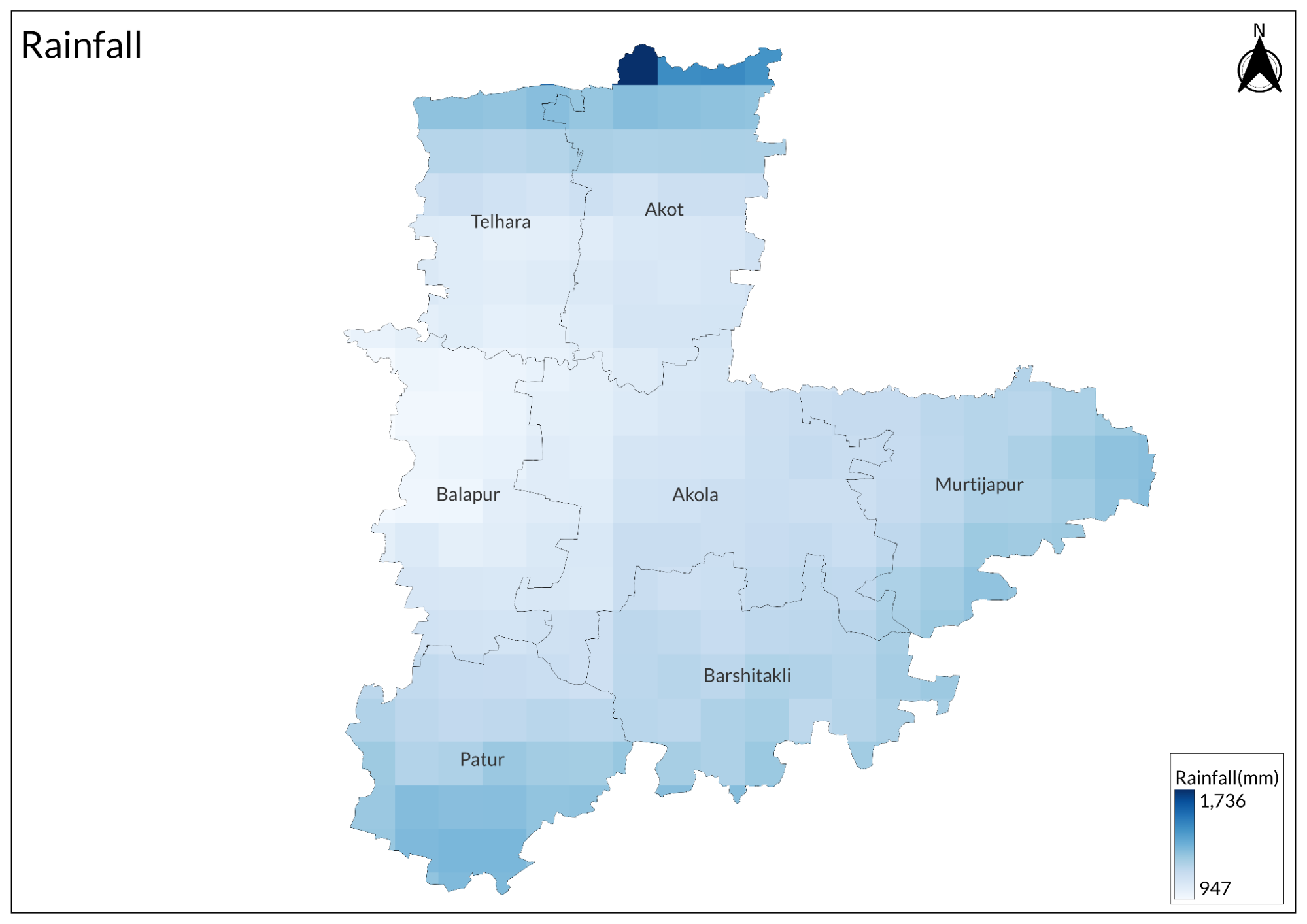
This is followed by the southwest monsoon season from July to September, with July being the wettest month, receiving an average rainfall of 700-1000 mm. October and November constitute the post-monsoon season, which receives a significantly lower average rainfall of 114 mm. The period from mid-November to the end of February marks the winter season, with December being the coldest month when average temperatures drop to around 17ºC.
According to the revised Gazetteer of 1977, the highest recorded maximum temperature in Akola was 47.8°C on May 22, 1947, while the lowest recorded minimum temperature was 2.2°C on February 9, 1887. Currently, the maximum temperature recorded is 45°C in May 2020, and the minimum recorded is 9.1°C.
Geology
The area of the district is primarily covered by two geological formations: Deccan Basalt and recent alluvium. Deccan Basalt constitutes more than 60% of the district, while the remaining 40% is composed of recent alluvial deposits. The Deccan Traps extend along the northern border and across the southern half of the district, surfacing through the soil in various locations.
Alluvial Composition: The alluvium consists of boulders, sand, clay, and silty materials deposited along the Purna River. This combination of geological features contributes to the region's diverse landscape and soil composition, which is vital for agriculture and local ecosystems.
Soil
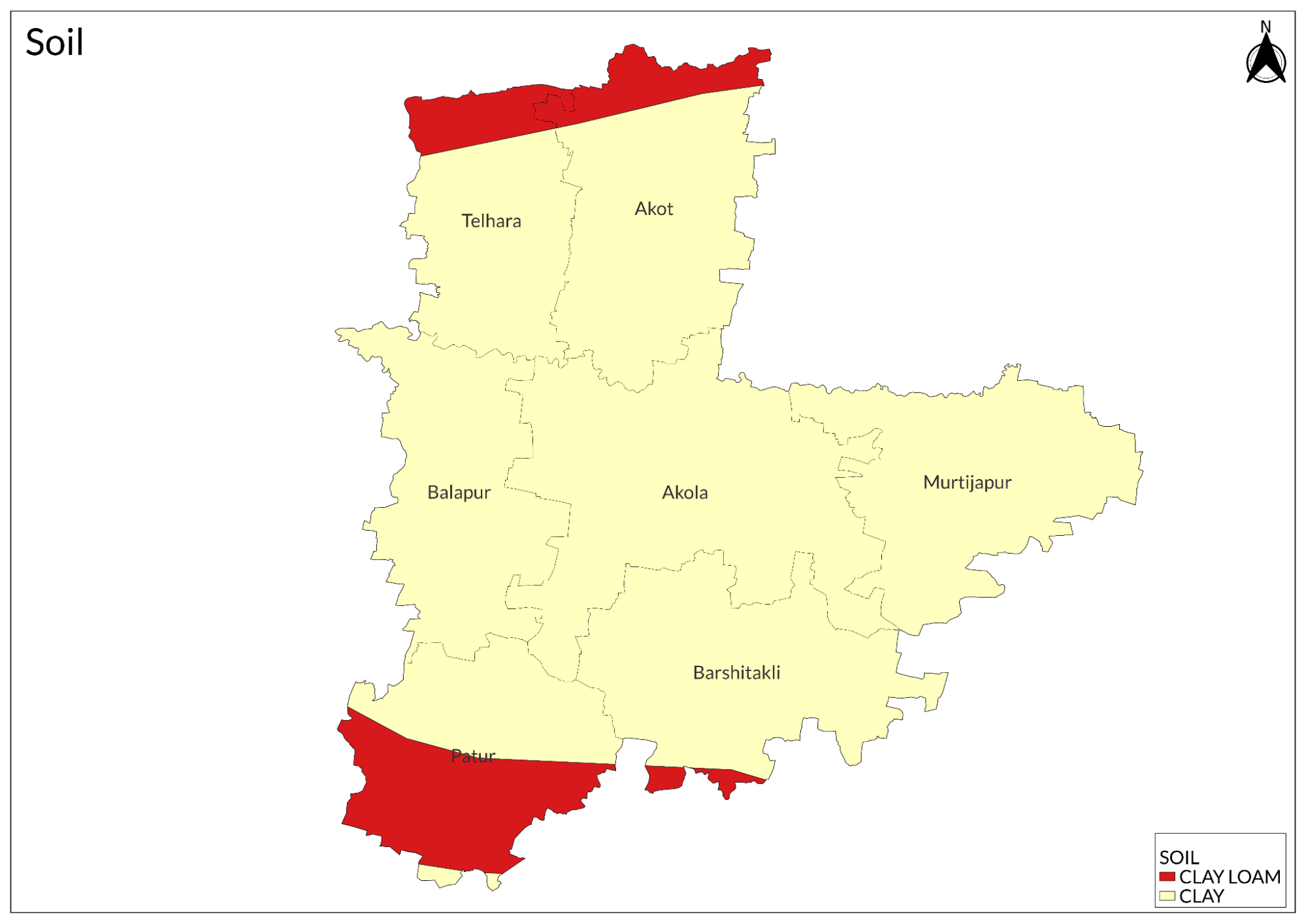
The soils in the district are derived from the Deccan Traps and are well-known for their fertility. They can be classified into three categories:
- Coarse Shallow Soil: Found in the middle part of the Patur and Barshi Takli tehsils.
- Medium Black Soil: Predominantly occurring in the plain central areas of trap origin.
- Deep Black Soil: Typically found in the valleys of the district.
These soil types contribute significantly to the agricultural productivity of the region, with medium and deep black soils being particularly favorable for cultivation due to their moisture-retaining capacity and nutrient content.
Minerals
The district is rich in several minerals, including:
- Hard and Compact Basalts: These are primarily used as building materials and cover a significant portion of the district.
- Salt: Found along the Purna River, contributing to the region's mineral wealth.
Additionally, there are numerous wells located near Dahihanda village in the southeast of Akot tehsil, which may enhance local water resources for agricultural and domestic use. The presence of these minerals supports both construction activities and local livelihoods.
Rivers
The Purna River is the main river of the district, with water flowing throughout the year. It rises in the Amravati district and flows westward across Akola into the Buldhana district. The river forms the northern boundary of Murtizapur, Akola, and Balapur tehsils, while it delineates the southern boundary of Akot.
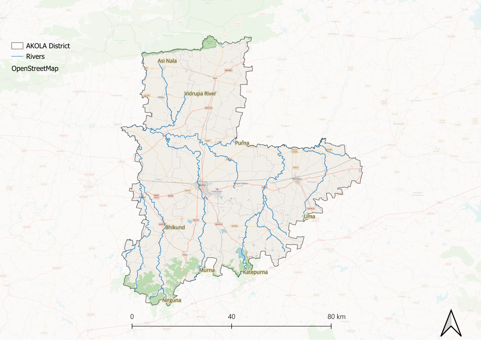
The Penganga River, which flows southeast across Washim district, also maintains a consistent flow throughout the year. The chief tributaries of the Purna include the Pedhi, Uma, Katepurna, Lonar, Morna, Nirguna, and Man rivers. Akola city primarily depends on the Morna River and its associated dams for water supply. Historically, these rivers provided additional defenses for the old fort at Balapur.
Other tributaries such as the Adan, Arnawati, and Pus rivers rise in Washim tehsil and flow through parts of Mangrul village in Sambhaji Nagar before joining the Penganga. Additionally, the Bembala River originates from a holy site in Karanja town, located south of Murtizapur tehsil, and eventually flows into the Wardha River in Yavatmal district.
The Purna River's watershed covers a significant area, contributing to its importance as a water resource for both agriculture and local communities.
Botany
The forests in the district are primarily composed of deciduous trees, featuring a diverse range of species including teak, ain, dhawara, and bijasal. Additionally, fruit-bearing trees such as behera and harra contribute to the biodiversity. Evergreen trees like neem, mango, karanji, and various species of Ficus provide valuable shade along roadsides. Other notable trees include salai, bel, tembhurni, char, and mahua, which is utilized in local spirit production.
The district also hosts shrubs like parijatak and umar (or sheng), which are commonly found throughout the area. Bamboo resources are limited, with only a few clumps of Dendrocalamus Strictus present. The Forest Department is considering projects to develop the extraction industry for rusa oil from rosa grass, which is valuable for perfume production.
These diverse forest resources play a crucial role in the local ecosystem, supporting both wildlife and human activities while contributing to the region's economic potential through sustainable forestry practices.
Wild Animals
The district is home to a variety of wild animals primarily found in reserve forests, including tigers (bagh), panthers (bibtya), sloth bears (bhalu), kolha (foxes), jackals, and wild cats (ran-manjar). Sambhar and chital (spotted deer) are commonly observed in the forests of the Chikhalwal and Patur regions. Additionally, common Indian langurs, rabbits, and mongooses inhabit the hilly areas. Historically, as noted in the British Gazetteer of 1910, the district once had abundant populations of chikara, wild boars, and nilgai, but these species are now primarily restricted to forested areas. The Katepurna Wildlife Sanctuary is particularly significant for wildlife observation, where one can also find species such as black bucks, leopards, wolves, hyenas, and various deer species. This sanctuary supports a rich biodiversity and is crucial for conservation efforts in the region.
Birds
The most frequently found birds in the district include the green pigeon and blue-rock pigeon. Land birds present in the area consist of the peafowl, sand grouse, grey partridge, and common quail, with bustards also sighted often. Among the waterbirds, various species such as wild ducks, teal, plovers, snipe, saras, cranes, curlews, and kulungs are commonly found in the region. The diversity of bird species reflects the rich biodiversity of the district, providing ample opportunities for birdwatching and ecological study.
Fishes
The Purna River and its tributaries are significant for fishing, hosting a variety of fish species. Notable species found in the river include maral, bam (or wahir), rahu, paha-din, dokada, tam, nain, khekada, kaso (or kachhwa), kawas (or kalosi), tewara, bhatmachhi, tepari, bharki, chal, papta sandkol, malganna, katarna, and jhinga. The river's diverse habitats, including riffles, pools, and runs, support this ichthyofaunal diversity, making it an important ecosystem for both local biodiversity and the fishing industry. The presence of deep water pools in certain areas ensures that these fish populations thrive year-round, further highlighting the ecological significance of the Purna River.
Forest Reserves
Katepurna Wildlife Sanctuary
Katepurna Wildlife Sanctuary is situated in the Akola district, covering an area of approximately 74 sq. km, and derives its name from the Katepurna River, which flows through the sanctuary. The vegetation in the sanctuary is characterized as a southern tropical dry deciduous forest, hosting over 115 species of plants, including behada, dhawada, moha, tendu, khair, salai, and amla. The sanctuary is renowned for its populations of four-horned antelopes and barking deer. Other wildlife includes black buck, leopard, wolf, wild boar, hyena, hare, nilgai, jungle cat, and monkeys. The Katepurna water reservoir within the sanctuary attracts many water birds; peafowl are commonly spotted along with various species of grassland and wetland birds. The sanctuary serves as an important habitat for both flora and fauna, making it a popular destination for nature lovers and wildlife enthusiasts. The best time to visit is between October and June, when the biodiversity is most vibrant. Access to the sanctuary is convenient by air, rail, and road, with Akola being the nearest major town.
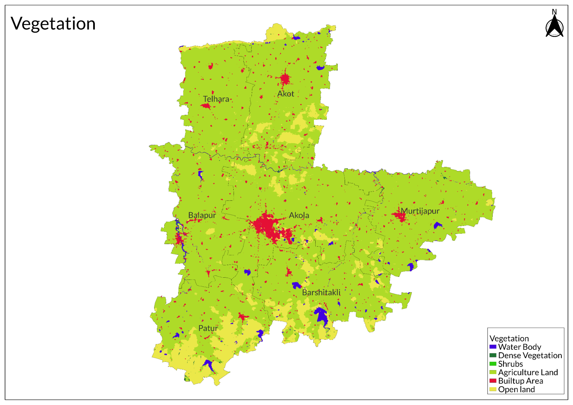
Land Use
Environmental Concerns
Deforestation
One of the primary causes of deforestation in Akola is the conversion of forests into agricultural land to meet the growing demand for food and cattle grazing. This conversion has resulted in significant ecological consequences, including the destruction of habitats and a decline in biodiversity. Additionally, forest fires and other natural events have contributed to the loss of tree cover in the area.
Land degradation is closely linked to deforestation activities, with soil erosion being a major concern. The removal of trees leaves soil exposed and vulnerable to erosion, which threatens agricultural productivity and food security in the region. In 2020, Akola had approximately 1,08,000 hectares of natural forest, accounting for over 20% of its land area. However, ongoing deforestation and land degradation make it increasingly susceptible to both natural and human-induced disasters.
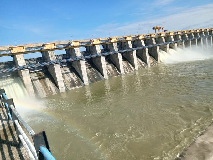
Water Scarcity
In recent years, the region has faced significant challenges due to a combination of factors, including poor monsoon seasons and over-extraction of groundwater. As of 2022, the water stock in major reservoirs, including the Katepurna dam, has fallen alarmingly low, leading to widespread concerns about water availability for both drinking and agricultural purposes. Reports indicate that Akola is one of the worst-hit districts in the Amravati division, with water levels in its reservoirs dropping to critical lows.
The reliance on water tankers has surged as local authorities scramble to provide potable water. In 2020, residents reported an increase in tanker services due to the depletion of natural water sources. This reliance on tankers not only highlights the severity of the crisis but also raises concerns about the long-term sustainability of water resources in the district.
Air Pollution
Air pollution in the Akola district, Maharashtra, has emerged as a significant public health concern, particularly due to the widespread use of biomass cooking fuels. It has been estimated that thousands of cases of chronic bronchitis, tuberculosis, cataracts among adult women, and stillbirths can be attributed to household air pollution resulting from these fuels. Research indicates that the use of biomass and kerosene for cooking is linked to adverse pregnancy outcomes, including preterm births and low birth weight. A study utilizing data from India’s 2003/04 District Level Household Survey II found that nearly 12% of stillbirths could be prevented through access to cleaner cooking fuels.
Climate Change Vulnerability
Akola district in Maharashtra, India, is highly vulnerable to the impacts of climate change due to its tropical wet and dry climate and various contributing factors. The vulnerability is assessed based on several criteria: exposure to climate change, sensitivity to its effects, adaptive capacity, and the severity of climate change itself. Akola's susceptibility is evident in changing rainfall patterns and extreme temperature fluctuations, which pose significant risks to the region.
The agricultural sector in Akola is particularly at risk, with cash crops such as jowar, rice, wheat, sugarcane, cotton, ragi, cashew nuts, barley, and millets likely to be adversely affected by these climatic changes. Additionally, the district is prone to droughts, further exacerbating the challenges faced by local farmers.
Recent studies have classified Akola as one of the districts highly vulnerable to extreme weather events and diminishing water security. With approximately 40% of Maharashtra's cropped area affected by climate-related issues, Akola's agricultural landscape is increasingly threatened.
Conservation Efforts
In May 2017, Aamir Khan visited Akola to promote better water facilities as part of his involvement with the Paani Foundation. During this visit, he participated in the Satyamev Jayate Water Cup, an initiative aimed at enhancing water conservation efforts. The Paani Foundation, co-founded by Aamir Khan, Kiran Rao, and others, focuses on drought prevention and watershed management in Maharashtra.
Sixteen years prior, a silk plant was established on 12 acres of land at a cost of several crores. However, the project faced challenges due to depleted underground water reserves, leading to its stagnation shortly after completion. Thanks to the training provided by Aamir Khan's Paani Foundation, residents have revived this project by implementing various water conservation techniques.
Biogas Rediscovered
In the Akola district, Maharashtra, innovative conservation efforts are gaining traction through the successful implementation of biogas plants, which have transformed local energy practices and waste management. Farmers like Vijay Ingle from Chittalwadi village and Shyamrao Deshmukh from nearby Tandulwadi have defied skepticism surrounding biogas technology and demonstrated its viability despite initial challenges.
Ingle, who installed a biogas plant at his dairy, faced doubts from the community due to the historical failures of similar projects in the Vidarbha region. However, he persevered and established a system that not only met his family's cooking and heating needs but also generated surplus gas for additional uses. His success inspired others in Chittalwadi, leading to the installation of 15 operational biogas plants in the village.
Similarly, Deshmukh tackled logistical issues by creatively adapting his biogas system. Initially hindered by the distance from his cowshed to his home, he devised an innovative solution using inexpensive rubber tubing instead of costly PVC pipes. This adaptation allowed him to transport gas effectively without significant financial investment, proving that even small-scale farmers could benefit from biogas technology.
The spread of these innovations has sparked renewed interest in biogas across the Akola district. Farmers who previously hesitated due to concerns about cow dung availability have realized that even limited cattle numbers can suffice for biogas production. The success stories of Ingle and Deshmukh have encouraged others to explore biogas as a sustainable energy source.
The government’s introduction of smaller biogas models, such as the Deenbandhu plant, has further facilitated this shift. With rising fuel costs and dwindling wood supplies, more farmers are turning to biogas as a practical solution for their energy needs. Agricultural officials emphasize the importance of guiding installation and maintenance to ensure successful implementation across the region.
Graphs
Water
Climate & Atmosphere
Forests & Ecology
Human Footprint
Sources
Collector Office Akola. Akola District Official Website. Akola District Administration, Akola.https://akola.gov.in/
Deccan Herald. 2021. 77% of Maharashtra’s Cropped Area Vulnerable to Climate Change: Study. Deccan Herald, Maharashtra.https://www.deccanherald.com/india/77-of-mah…
Down to Earth. Biogas Rediscovered. Down to Earth, India.https://www.downtoearth.org.in/environment/b…
India Today. 2022. Water Crisis in Maharashtra: Digging Riverbed, Tankers, Locals Face Shortage. India Today, Maharashtra.https://www.indiatoday.in/india/story/water-…
Khadri, S.F.R., & Sanjay S. Deshmukh. 2013. Soil Texture Analysis of Katepurna River Basin, Akola District, Maharashtra with reference to Water Resource Management.International Journal of Scientific & Engineering Research, Vol. 4, Issue 2, February, pp. 1. ISSN 2229-5518.https://www.ijser.org/researchpaper/Soil-tex…
Wagh, S.P. 2016. Studies on Factors of Air Pollution in Akola District. International Journal of Researches in Biosciences, Agriculture and Technology (IJRBAT), Vol. IV, Issue 3, September. ISSN 2347-517X. Vishwashanti Multipurpose Society.https://ijrbat.in/upload_papers/071220160335…
Last updated on 6 November 2025. Help us improve the information on this page by clicking on suggest edits or writing to us.