Contents
- History
- Trade & Ancient Trade Routes
- Modes of Transportation in the District
- Train and Rail Systems
- Overview of Bus Networks
- Autos & Shared Vehicles
- Ferries & Water Transport
- Traffic Map
- Communication Networks
- Newspapers & Magazines
- What’s on the Billboards? A Look at Chandrapur’s Hoardings
- Postal Services
- Graphs
- Road Safety and Violations
- A. Cases of Road Safety Violations
- B. Fines Collected from Road Safety Violations
- C. Vehicles involved in Road Accidents
- D. Age Groups of People Involved in Road Accidents
- E. Reported Road Accidents
- F. Type of Road Accidents
- G. Reported Injuries and Fatalities due to Road Accidents
- H. Injuries and Deaths by Type of Road
- I. Reported Road Accidents by Month
- J. Injuries and Deaths from Road Accidents (Time of Day)
- Transport Infrastructure
- A. Household Access to Transportation Assets
- B. Length of Roads
- C. Material of Roads
- D. Licenses Issued
- Bus Transport
- A. Number of Buses
- B. Number of Bus Routes
- C. Length of Bus Routes
- D. Average Length of Bus Routes
- E. Daily Average Number of Passengers on Buses
- F. Revenue from Transportation
- G. Average Earnings per Passenger
- Communication and Media
- A. Household Access to Communication Assets
- B. Newspaper and Magazines Published
- C. Composition of Publication Frequencies
- Sources
CHANDRAPUR
Transport & Communication
Last updated on 6 November 2025. Help us improve the information on this page by clicking on suggest edits or writing to us.
History
Trade & Ancient Trade Routes
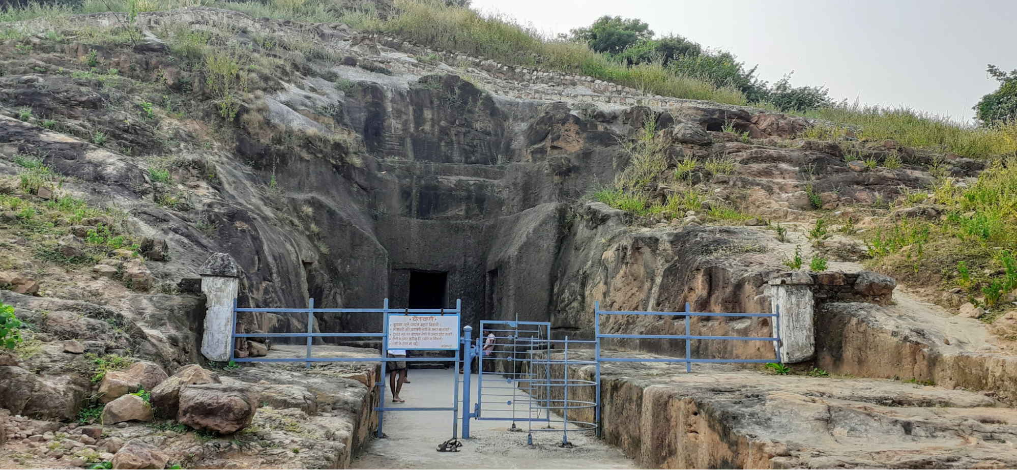
The Chandrapur district, it has long formed part of inland routes connecting local settlements and markets in central India. Among the earliest indications of this trade connectivity in the district can be found at Vijasan Tekdi, more commonly known as the Vijasan Caves, situated near Bhadravati. Built around the 1st century CE during the Satavahana period, the caves are about 2,000 years old and contain Buddhist art and architecture typical of early monastic sites. Scholars generally agree that Buddhist caves and monasteries across India were rarely built in isolation; they often emerged along busy trade routes where travelling monks and merchants relied on each other for support and shelter.
In this respect, Vijasan was likely part of a network of well-used inland routes in Maharashtra. Today, the site is considered the largest group of Buddhist caves in the Vidarbha region and still holds religious importance, hosting international Buddhist gatherings.
Centuries later, under the rule of the Gonds, Chandrapur is said to have emerged as a notable centre for trade and transport in this part of the Deccan. According to the district Gazetteer (1972), agricultural produce was brought in from distances of up to 400 km, pointing to the scale of the area’s transport links.
During the rule of the Bhosales of Nagpur, trade in cotton, betel-nuts, and salt strengthened ties between local producers and larger markets. Skilled weavers and merchants played an active part in this economy, their livelihoods tied closely to the flow of goods along regional routes.
By the 20th century, Chandrapur’s trade patterns changed again as transport and communication improved. The effects of the World Wars, and later development efforts, led to the growth of shops in most villages and the spread of weekly markets, allowing producers and traders to reach local buyers more easily.
Road building also supported this growth. The Chandrapur–Mul–Umrer road, built in 1891, helped connect the main centres of the district. After the famine of 1900, it is additionally noted that new roads were laid to reach remote villages.
Modes of Transportation in the District
Train and Rail Systems
Chandrapur district falls under the Nagpur Division of the Central Railway Zone, placing it on one of the country’s busiest rail networks. This network supports both passenger movement and freight transport, especially coal and cotton; which have long been vital to the district’s economy.
The history of railway transport in Chandrapur dates back to the late 19th century and is notably very closely linked to the region’s coal mining industry. In 1877, the Wardha–Warora railway line and its main purpose was to transport coal from the Warora State Colliery (a government-owned coal mine). At that time, the railway was run by a private company known as the Great Indian Peninsula Railway (GIPR) — one of the earliest railway companies in India, until the government later took control.
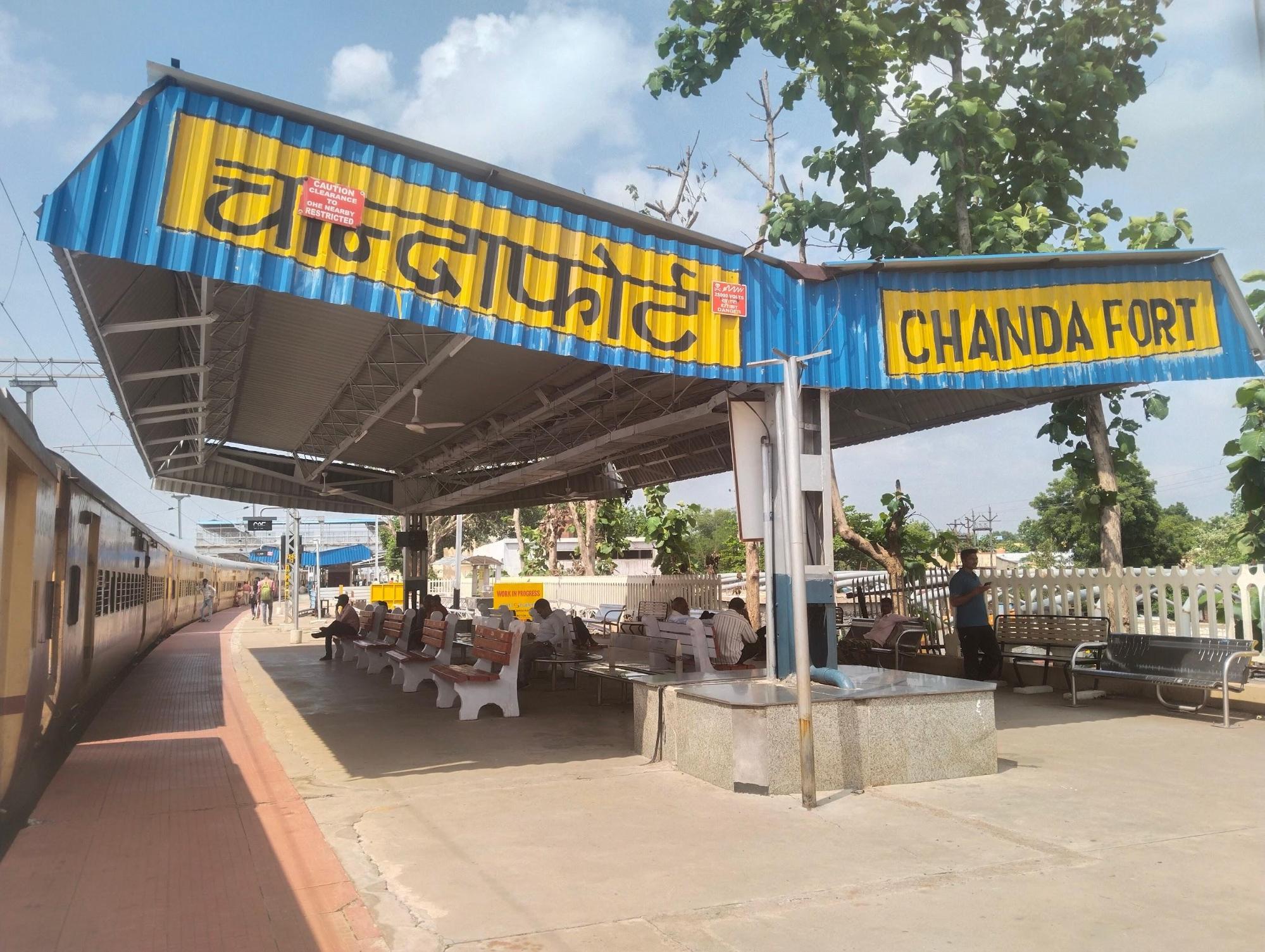
In 1908, this railway was extended from Warora to Ballalpur, an industrial town known for paper and coal production. This extension passed through Chandrapur town, adding about 63 km to the line. Four stations were built on this stretch: Bhandak, Tadali, Chandrapur, and Ballarshah (now Ballarpur). This new route made it much easier to move coal from the mines to other parts of India and also helped traders transport cotton, which was another important local crop.
As the railway grew, it connected Chandrapur to major cities such as Nagpur, Mumbai, and Kolkata. Between 1908 and 1916, another railway line — the Bengal–Nagpur line — was built to connect Chandrapur to Gondia, a town northeast of the district.
Chandrapur also became part of the Grand Trunk Route, which is one of India’s oldest and longest railway routes connecting Delhi to Chennai. This put Chandrapur on a major national railway corridor.
Today, Chandrapur remains well connected by rail. Long-distance trains such as the Delhi–Madras Grand Trunk Express and the Nagpur–Hyderabad Passenger still pass through the district.
Overview of Bus Networks
Buses remain an important mode of transport in Chandrapur district for both local travel and longer inter-district routes. Services are run by both the Maharashtra State Road Transport Corporation (MSRTC) and private operators. Despite the spread of routes, Chandrapur is one of the districts in the region that still lacks a dedicated city bus service. Recent studies have highlighted a growing need for a reliable urban bus network to improve daily connectivity, especially as the district’s population continues to expand.
Public bus services in Chandrapur have their roots in the early years after Independence. In 1953, the area was included under the Nagpur Division of the newly formed MSRTC. Before MSRTC took charge, buses were operated by the Central Provinces Transport Services, which were purchased by the State Government in 1955 and reorganised as the Provincial Transport Services, Nagpur. According to the district Gazetteer (1972), official bus routes in Chandrapur first began in 1953, connecting Nagpur–Chandrapur, Wardha–Chandrapur, and Nagpur–Chimur.
Autos & Shared Vehicles
Local conveyance in the district, other than buses, also depend on cycle rickshaws and auto rickshaws which operate chiefly for short distances. Auto rickshaws commonly run without meters; fares are settled by negotiation.
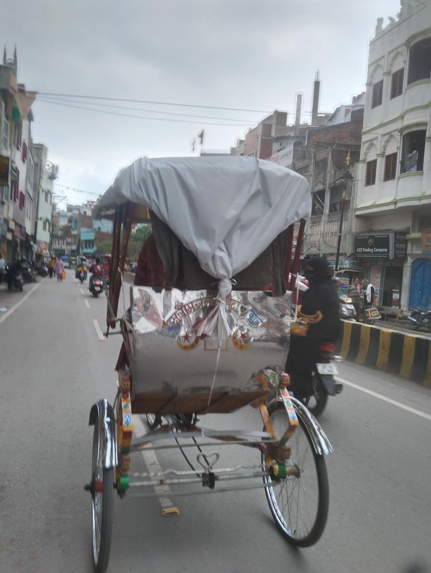
Locals say cycle rickshaws remain in regular use, particularly in older markets and congested lanes. Shared auto rickshaws ply fixed routes, carrying multiple passengers bound for similar destinations at a standard fare, supplementing areas where other public transport services are limited.
Ferries & Water Transport
Water transport once formed an essential part of the district’s mobility.Chandrapur has many rivers and streams, especially in its hilly and forested parts, which often cut off villages and roads, particularly during the rainy season. In the past, when bridges were few, crossing these rivers was a major challenge for transporting people, farm produce, and goods to local markets.
To deal with this, according to the district Gazetteer (1972), the Zilla Parishad ran small local ferries on key routes. For example, the Erai River crossing near Chandrapur and Mul Bazar used a temporary bridge in the dry months, but once the monsoon flooded the river, the bridge would be dismantled and replaced by a ferry service. This seasonal system kept travel and small trade routes open all year round.
Larger rivers needed bigger boats. ‘A’ class ferries — which could carry heavier loads and more passengers — were introduced on important roads where building a permanent bridge was too expensive or technically difficult at the time. Three main ferries noted in the district Gazetteer (1972) were:
- Hardoli Ghat Ferry on the Brahmapuri–Wadsa road
- Arsoda Ghat Ferry on the Brahmapuri–Armori road
- Haran Ghat Ferry on the Mul–Chamorshi road
These crossings were vital links for nearby villages. They carried farm goods, timber, and passengers, connecting settlements to main roads and markets.
Gradually, under India’s Five-Year Plans, more permanent bridges were built, which replaced most ferry routes. Today, only a few small local ferries operate in remote areas where bridges are still not practical, but they no longer play the central role they once did.
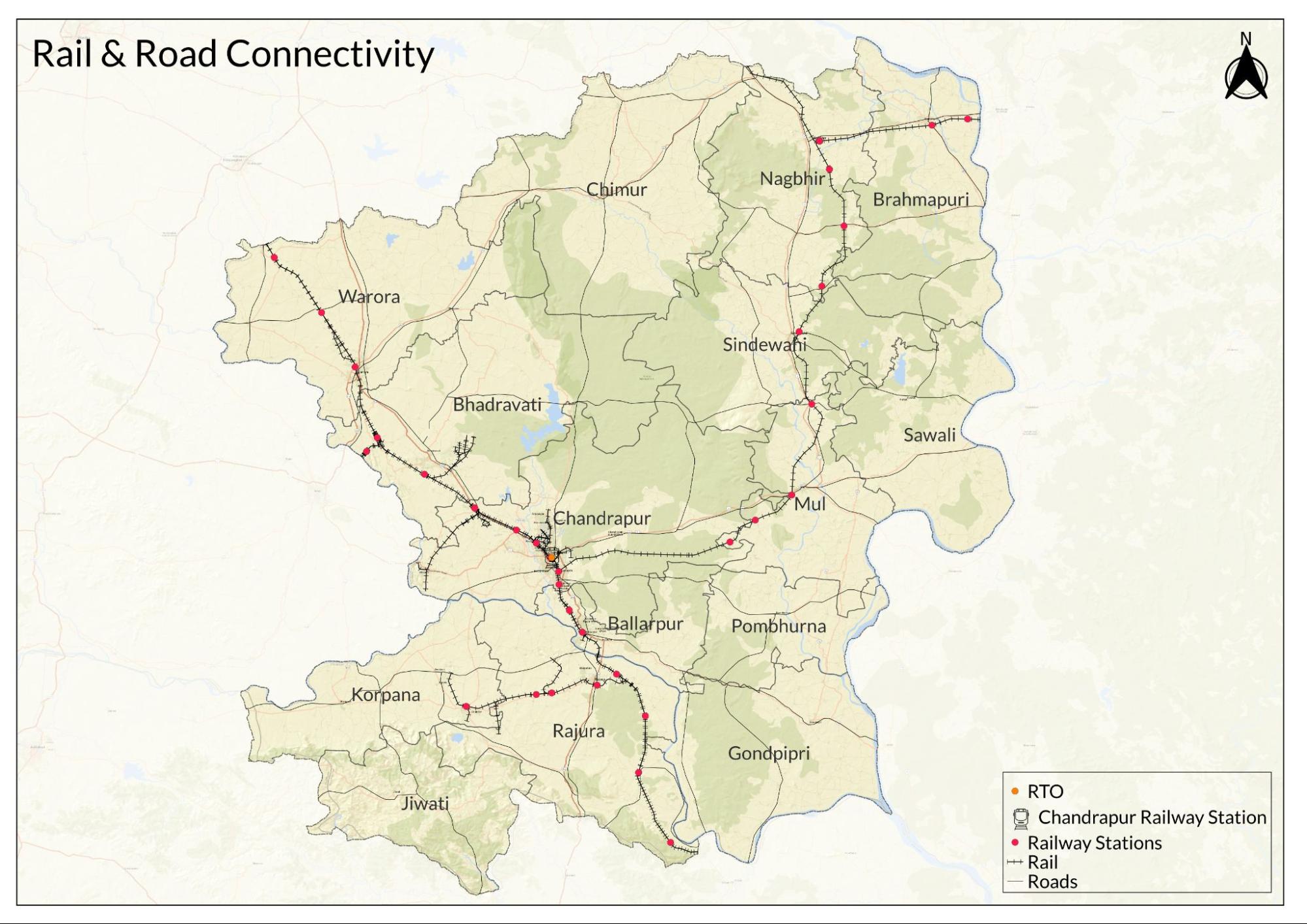
Traffic Map

Communication Networks
Newspapers & Magazines
A number of newspapers and periodicals are published within Chandrapur district alongside those printed outside but widely circulated locally. The district Gazetteer (1972) lists several local titles that were in circulation during the 20th century, including Athavadyachi Pukar, Bharat Vijayi, Chandrapur Darshan, Gondawana, Vividh Bharati, Chandrapur Nagarpalika Vritta, and Chandrapur Parishad.
Among more recent local publications, Bramhapuri Blast, a weekly newspaper based in Bramhapuri, continues to cover local news and community events, keeping residents informed about developments in the area.
Deshonnati is another significant newspaper serving Chandrapur and neighbouring regions, with coverage ranging from politics and local governance to social and cultural issues. Other well-read publications in the district include Lokmat, Navbharat, and Tarun Bharat, which together form part of the regular news cycle for many households in Chandrapur.
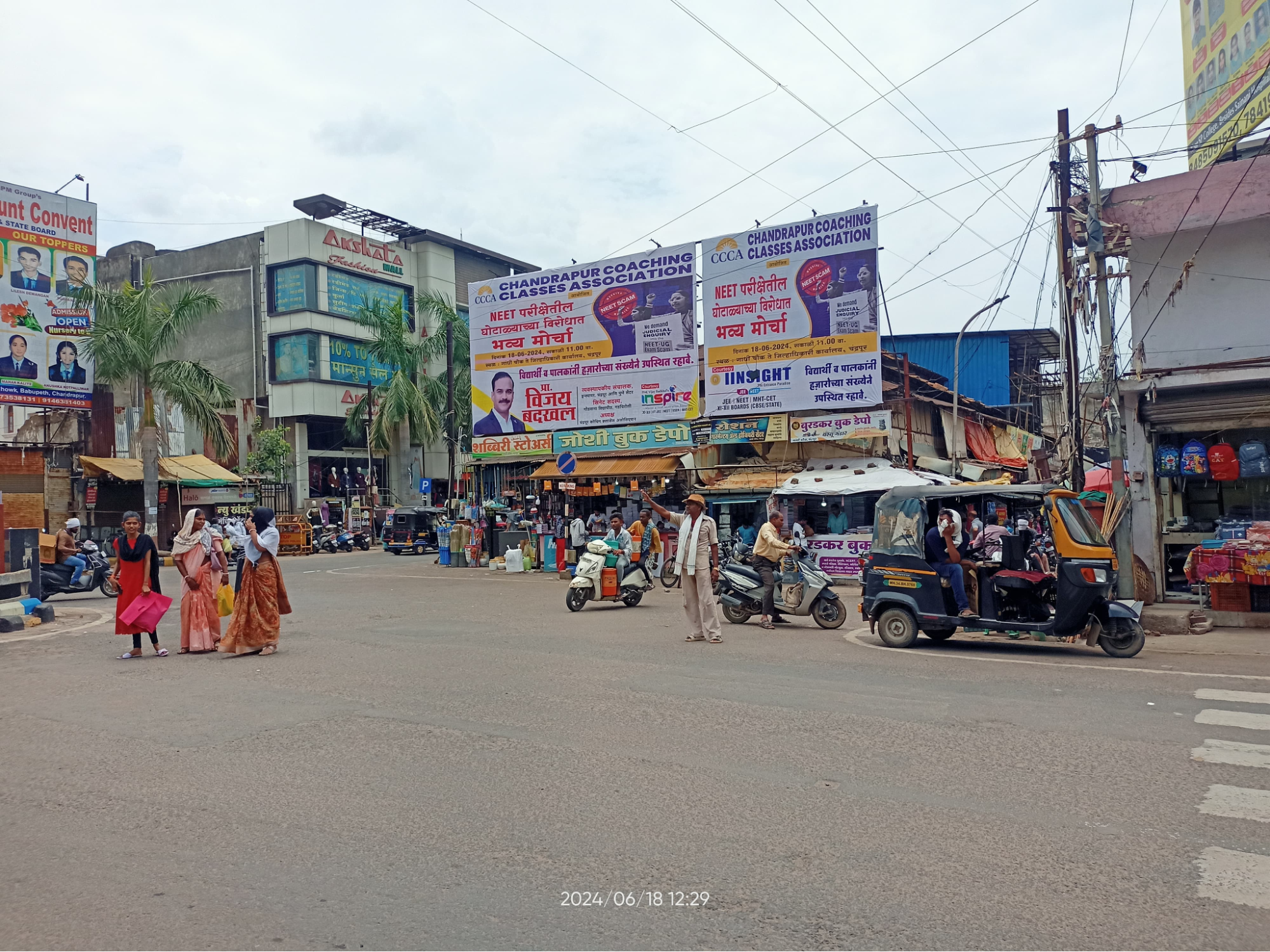
What’s on the Billboards? A Look at Chandrapur’s Hoardings
In Chandrapur, billboards and hoardings are a familiar part of the streetscape. Many of these advertise jewellery shops, which remain popular because gold jewellery holds strong cultural and social importance in the region.
In recent years, locals say that billboards for private coaching classes have also become more common, especially along main roads and near schools. This growth points to an increasing demand for exam preparation and after-school tuition, as more families in the district are likely paying for private classes to help children prepare for board exams, entrance tests, and other competitive exams.
Postal Services
In Chandrapur district, traditional postal services such as postcards and inland letters are still used, especially in rural areas and among older residents. These simple forms of communication remain popular for sending short messages, greetings, and family updates. While their use has declined with the spread of mobile phones and digital messaging, locals say postcards and letters continue to hold sentimental value — they are often kept as keepsakes or used on special occasions and festivals.
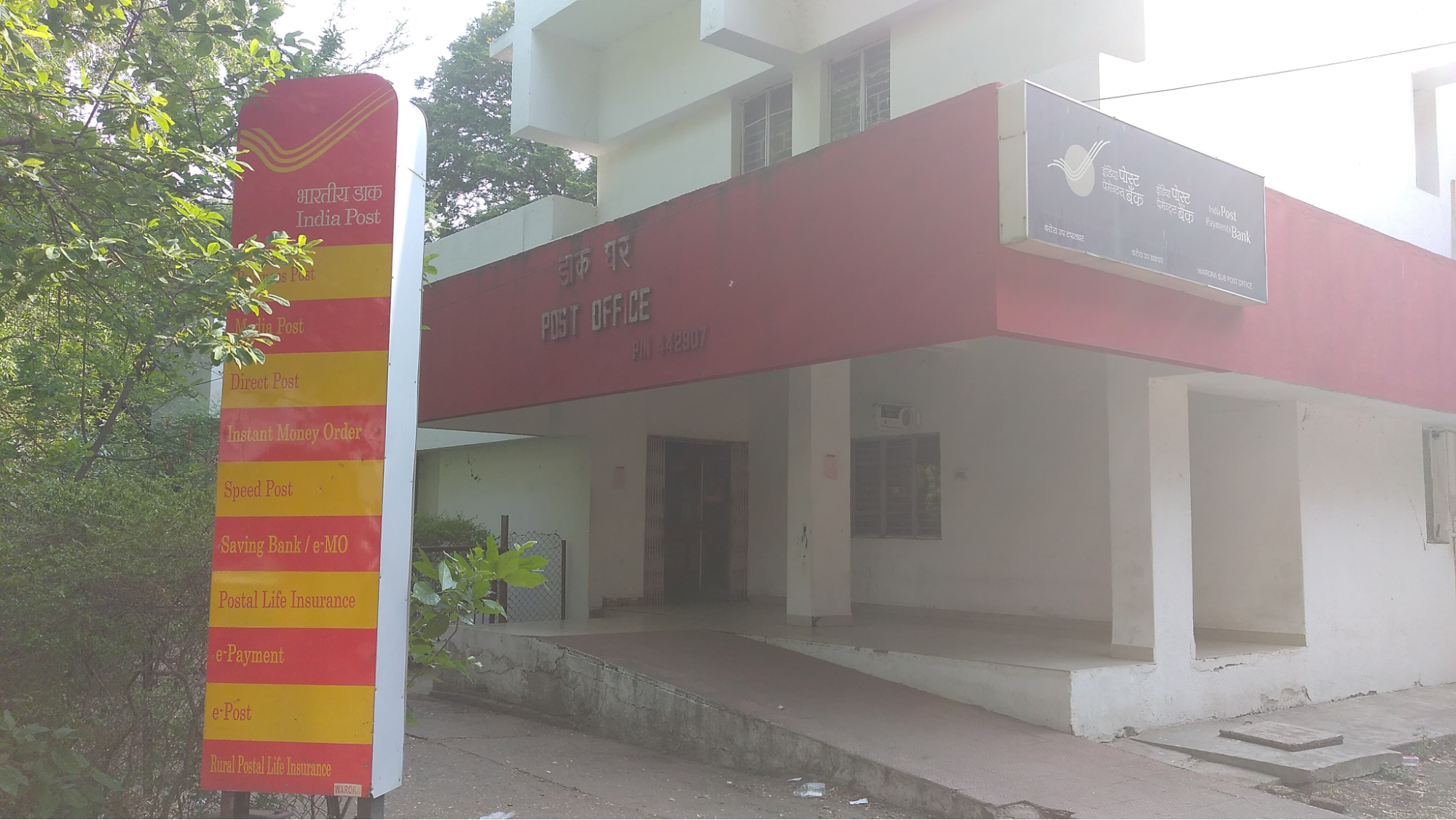
The post office remains important as a trusted place for savings. Many people, especially older account holders and rural families, continue to keep their money in post office savings accounts because they are backed by the government, which gives depositors confidence that their money is safe. The postal system offers fixed deposits, recurring deposits, and other small savings schemes, which provide a secure way for people to set aside money for future expenses.
Graphs
Road Safety and Violations
Transport Infrastructure
Bus Transport
Communication and Media
Sources
Maharashtra State Gazetteers. 1972. Chandrapur District. Directorate of Government Printing, Stationary & Publications, Government of Maharashtra, Mumbai.
Russel V. ed. 1905. Central Provinces District Gazetteers: Chanda District. Pioneer Press, Allahabad.
S.R. Marve, S.R. Shende, and A.N. Chalkhure. 2018. “Public Transportation System in Chandrapur City.” Vol 4, no 10. International Journal of Scientific Research in Science, Engineering and Technology (IJSRSET).
World Health Organization. Road Safety. WHO, Geneva.https://www.who.int/health-topics/road-safet…
Last updated on 6 November 2025. Help us improve the information on this page by clicking on suggest edits or writing to us.