Contents
- Physical Features
- Climate
- Geology
- Soil
- Minerals
- Rivers
- Botany
- Wild Animals
- Birds
- The avian fauna of Nashik is particularly rich, with the Nature Conservation Society documenting up to 325 bird species in 2004. The region's diverse topography, including plains, valleys, hilly regions, and aquatic zones, combined with varied plant...
- Forest Reserves
- Nandur Madhyameshwar Bird Sanctuary
- Mamdapur Conservation Reserve
- Regional Sanctuaries: Kalsubai and Yawal
- Land Use
- Environmental Concerns
- Deforestation
- Water Pollution
- Water Scarcity
- Climate Change Vulnerability
- Conservation efforts/protests
- Protests against Tata Power’s 100 MW Solar Power Plant
- Human chain to protest against the concretization of the ghats
- Green Buffer Zone
- Seaplane Services
- Environmental NGO’s
- CERE (Centre for Environmental Research and Education)
- Eco Club Nashik
- Green Vision Nashik
- Nisarg Seva Samiti
- Paryavaran Dakshata Mandal (PDM)
- Sahyadri Nisarga Mitra (SNM)
- Save Godavari Foundation
- Graphs
- Water
- A. Rainfall (Yearly)
- B. Rainfall (Monthly)
- C. No. of Rainy Days in the Year (Taluka-wise)
- D. Evapotranspiration Potential vs Actual Numbers (Yearly)
- E. Annual Runoff
- F. Runoff (Monthly)
- G. Water Deficit (Yearly)
- H. Water Deficit (Monthly)
- I. Soil Moisture (Yearly)
- J. Seasonal Groundwater Levels: Bore Wells
- K. Seasonal Groundwater Levels: Dug Wells
- Climate & Atmosphere
- A. Maximum Temperature (Yearly)
- B. Maximum Temperature (Monthly)
- C. Minimum Temperature (Yearly)
- D. Minimum Temperature (Monthly)
- E. Wind Speed (Yearly)
- F. Wind Speed (Monthly)
- G. Relative Humidity
- Forests & Ecology
- A. Forest Area
- B. Forest Area (Filter by Density)
- C. Wildlife Projects (Area and Expenses)
- Human Footprint
- A. Nighttime Lights
- Sources
NASHIK
Environment
Last updated on 6 November 2025. Help us improve the information on this page by clicking on suggest edits or writing to us.
Nestled in northern Maharashtra, Nashik is a land of contrasts, where sprawling vineyards and ancient rivers coexist with rapid urban expansion. Renowned as India's wine capital, it has fertile soils and a favourable climate that have shaped a thriving agricultural landscape. Flanked by the rugged Western Ghats in the west and the vast Deccan Plateau in the east, Nashik’s geography is as diverse as its cultural heritage. The mighty Godavari River, originating in Trimbakeshwar, nourishes its lands, sustaining both people and ecosystems. However, with time, Nashik faces pressing environmental concerns. Rapid urbanization, deforestation, and shifting climatic patterns pose challenges to its delicate ecological balance.
Physical Features
Nashik district occupies a significant geographical position in Maharashtra, situated between 18.33° and 20.53° North latitude and between 73.16° and 75.16° East longitude. The district stands at an elevation of 565 meters above mean sea level, making it one of the more elevated regions in Maharashtra. With its expansive area of 15,582 square kilometres, it ranks as the third largest district in Maharashtra, showcasing a remarkable diversity in its physical landscape.
The district's terrain is distinctly divided into two major geographical regions, each with its own unique characteristics. The western portion is dominated by the magnificent Western Ghats, also known as the Sahyadri range, which runs in a north-south direction. This mountainous region is characterized by its rugged terrain, featuring numerous deep ravines and steep valleys that create a complex topographical network. The challenging landscape of this western section significantly impacts agricultural activities, limiting cultivation to only the most basic forms in scattered, suitable areas.
In stark contrast, the eastern portion of the Nashik district presents an entirely different geographical character. This region, situated on the Deccan Plateau, offers a more hospitable landscape for human activities. The terrain here is notably open and flat, blessed with fertile soil that has made it highly conducive to cultivation. The most prominent feature in this eastern section is the Satmala-Chandwad Range, which stretches from east to west, serving as a crucial geographical divide. This range plays a vital role in the district's hydrology, acting as a natural watershed that determines the flow direction of various rivers in the region.
The district's boundaries reflect its strategic position in Maharashtra, sharing borders with multiple districts and even another state. It is bounded by Dhule district to the north, Jalgaon district to the east, Aurangabad district to the southeast, and Ahmednagar district to the south. On its southwestern frontier, it shares a boundary with Thane district, while its western and northwestern borders connect with Gujarat's Valsad, Navsari, and The Dangs districts. This geographical positioning has historically made Nashik an important crossroads for trade and cultural exchange in the region.
Climate
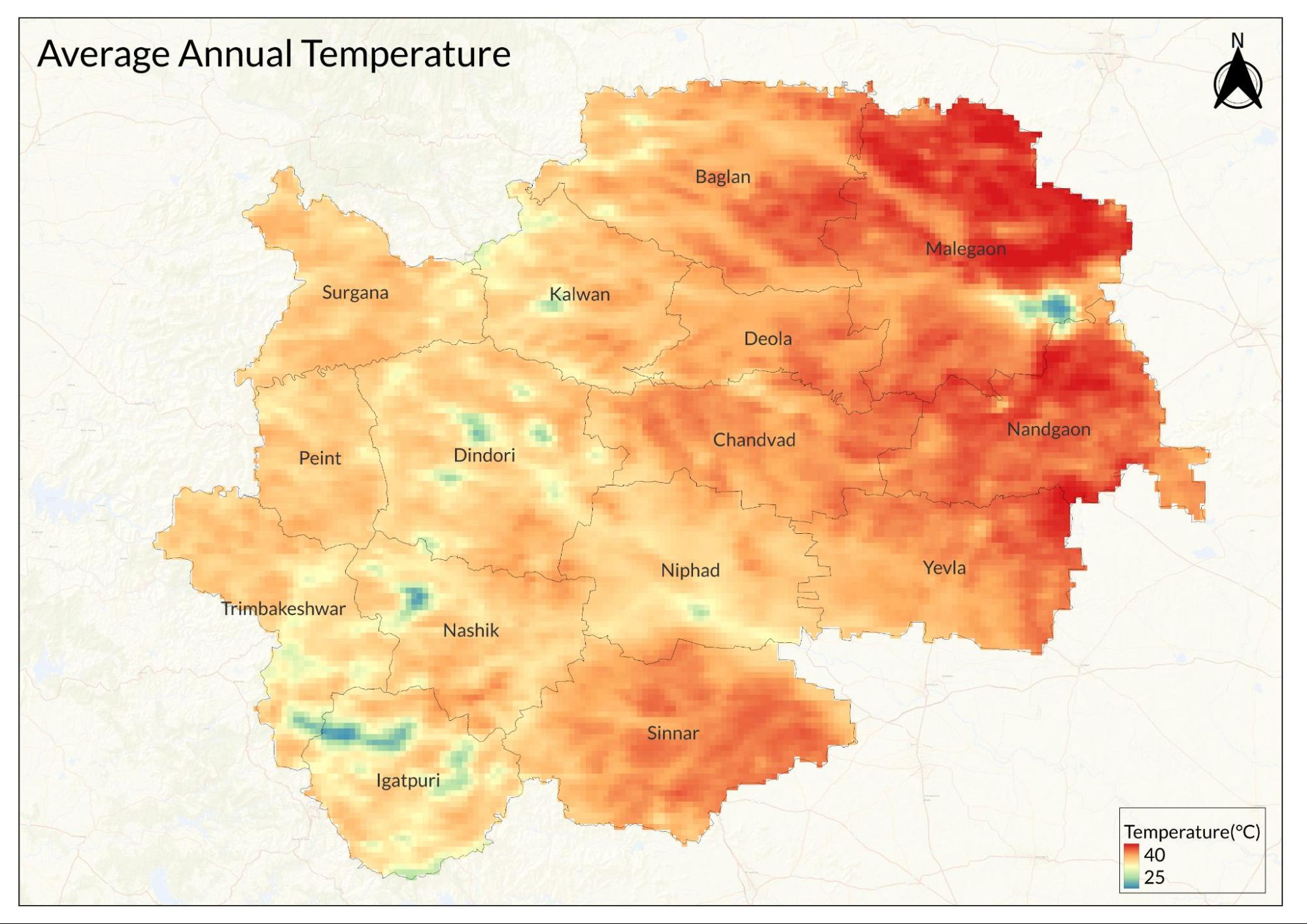
Nashik's climate is a modified tropical wet and dry pattern, influenced by its elevation of 700 meters above sea level. The high altitude creates moderate temperatures compared to other parts of Maharashtra, with distinct seasonal variations throughout the year. The cool season runs from November through February, with daytime temperatures around 28°C and nights averaging 10°C. This period is characterized by very dry air and significant day-night temperature differences. October sees a brief temperature rise before the cool season begins.
The district's varied topography creates diverse microclimates across its regions. Areas like Surgana, Peth, and Igatpuri experience Konkan-like weather, while Niphad, Sinnar, and Dindori share characteristics with Western Maharashtra. The Yeola, Nandgaon, and Chandwad blocks have climate patterns similar to the Vidarbha region.
Geology
Nashik's geological framework is primarily defined by its position on the western edge of the Deccan Plateau, where it forms part of the massive Deccan Trap volcanic formation. This geological setting dates back to the end of the Cretaceous period, characterized by extensive basaltic lava flows that shaped the region's fundamental structure.
The Western Ghats, or Sahyadri range, dominate the western portion of the district, representing some of the oldest exposed volcanic rocks in the region. These mountains consist of multiple layers of basalt flows, creating the characteristic stepped appearance of the terrain. The weathering of these basaltic rocks has contributed to the formation of deep valleys and ravines that characterize the western landscape. In the eastern section, the geology transitions to the typical Deccan Plateau formation, with more gentle slopes and broader valleys. The Satmala-Chandwad Range, cutting across the district from east to west, represents a significant geological divide. This range influences both the terrain and drainage patterns, creating distinct watershed areas that direct water flow either toward the Godavari or the Tapti river systems.
The district's river valleys showcase the long-term effects of geological processes, with the Godavari and its tributaries carving through the basaltic rock to create fertile alluvial plains. These valleys contain deposits of younger sediments overlying the basement volcanic rocks, contributing to the region's agricultural productivity.
Soil
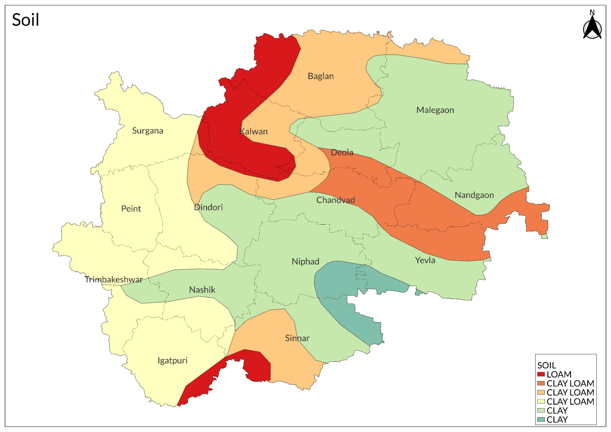
The soils of Nashik district exhibit remarkable diversity, closely tied to the region's varied geology and topography. This diversity creates distinct agricultural zones that mirror different regions of Maharashtra, earning Nashik its reputation as "Mini Maharashtra."
In the western region, dominated by the Western Ghats, the soil is predominantly rocky and shallow. These soils are derived from weathered basalt and are characterized by their limited depth and high stone content. The Surgana, Peth, and Igatpuri areas feature soil conditions similar to the Konkan region, with lateritic soils on the upper slopes and more fertile deposits in the valleys. The central and eastern plains show a marked transition in soil types. The Niphad, Sinnar, and Dindori blocks contain deep, fertile black soils similar to those found in Western Maharashtra. These soils, derived from basaltic parent material, have excellent moisture retention properties and are rich in minerals, making them ideal for the cultivation of various crops, including grapes, onions, and cereals. In the eastern sections, particularly in Yeola, Nandgaon, and Chandwad blocks, the soils share characteristics with the Vidarbha region. These areas feature medium black to shallow soils, suitable for growing cotton and various dry-land crops. The soil depth varies considerably, influenced by the local topography and erosion patterns.
The river valleys, particularly along the Godavari and its tributaries, contain highly fertile alluvial soils. These soils are characterized by their deep profiles, good drainage, and high organic matter content, making them particularly valuable for intensive agriculture and horticulture.
Minerals
The predominant basaltic terrain hosts a variety of mineral deposits, with the most significant being building materials derived from the widespread basalt deposits. The district contains substantial deposits of black stone, which is quarried extensively for construction purposes. River valleys, particularly along the Godavari and its tributaries, yield quality sand deposits that serve the construction industry.
Rivers
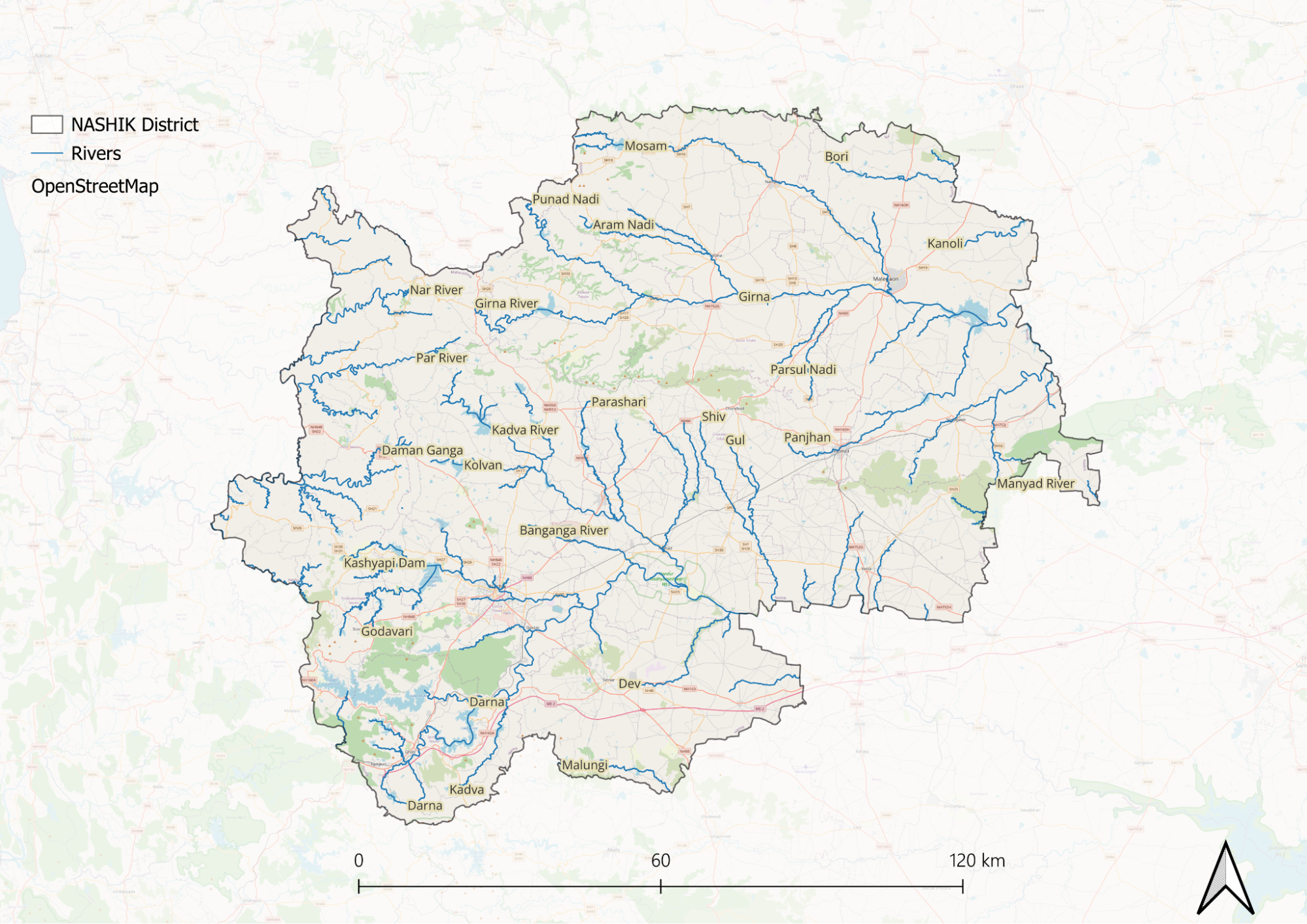
The Godavari River, known as the 'South Ganges,' dominates Nashik's river system. It originates at Trimbakeshwar in the Brahmagiri Mountains, 24 kilometers from Nashik city, and flows through the district's heart. Recent restoration efforts have improved its ecological health within city limits.
The Satmala-Chandwad Range divides the district's drainage into two systems. South of the range, the Kadva and Darna rivers join the Godavari, creating fertile agricultural valleys. North of the range, the Girna River and its tributary, the Mosam, flow eastward to join the Tapti River system.
The western portion features rivers flowing to the Arabian Sea, including the Daman Ganga. Other significant rivers include the Vaitarana, Bhima, Kashyapi, and Darana. These rivers support agriculture, urban needs, and host numerous dams for irrigation and water supply.
Botany
The spectrum analysis reveals that herbs dominate at 61.2% of the total flora, followed by trees at 15%, climbers at 12%, and shrubs at 9.3%, while epiphytes and parasites make up smaller proportions.
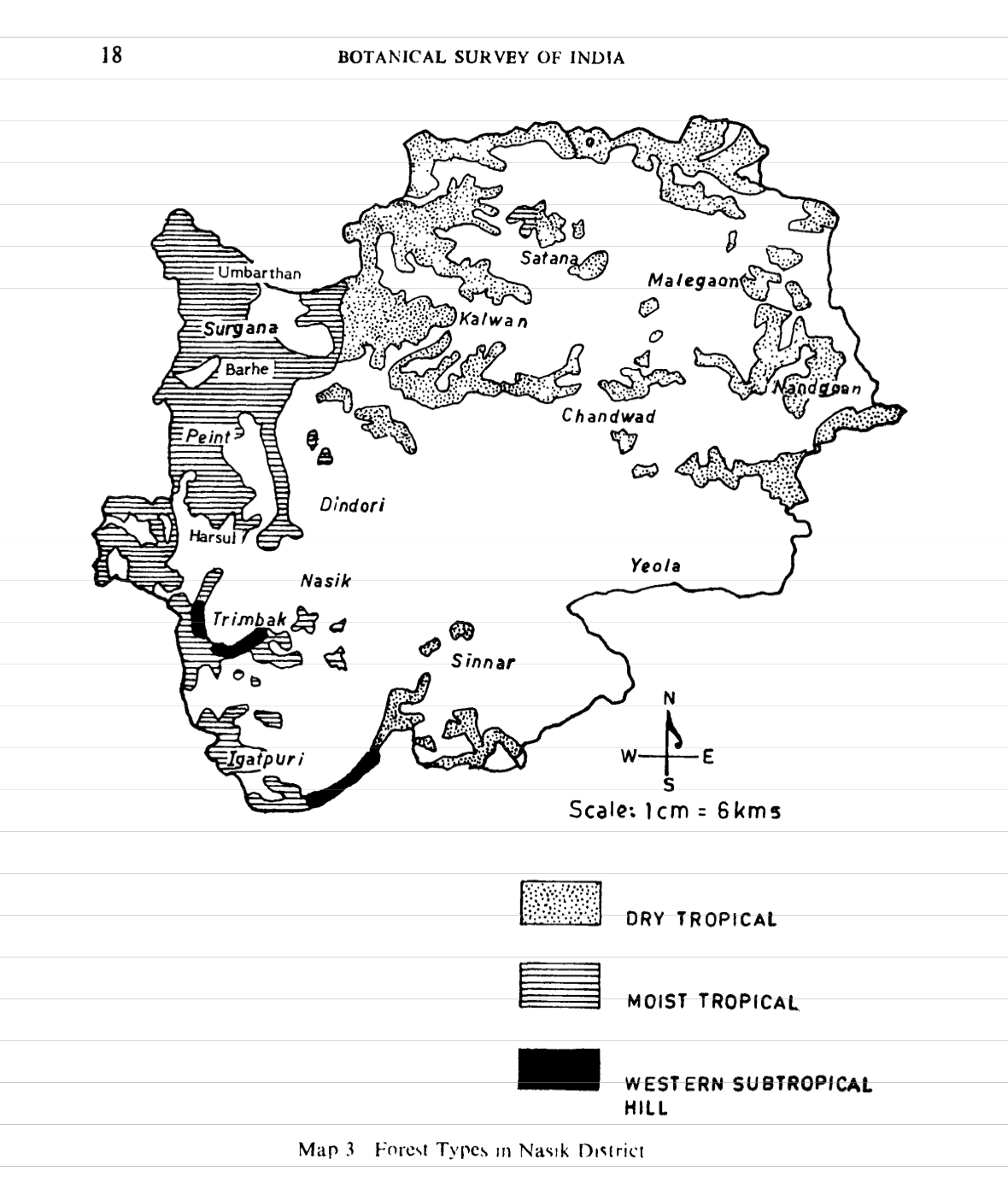
The western part of the district is characterized by Moist Tropical Forests, which feature semi-evergreen species and dense canopies. These forests are primarily found in two subtypes: the Mangifera-Syzygium type in plateau regions and the Terminalia-Mangifera type in valley areas. The moist forest zones typically support rich biodiversity with multiple canopy layers and diverse understory vegetation. In contrast, the central and eastern regions are dominated by Dry Tropical Forests, which are more open and understocked. These areas include dry teak forests and southern dry mixed deciduous forests, adapted to lower rainfall conditions. The vegetation here is notably sparse compared to the western regions, with species specifically adapted to withstand drier conditions and seasonal variations.
The Western Subtropical Hill Forests, found specifically in the Anjaneri and Trimbak regions, represent a unique ecosystem within the district. These forests occur in narrow strips on gentle slopes where soil conditions are favorable and contain a mix of evergreen and semi-evergreen species. They are particularly characterized by the dominance of species like Mangifera indica and Syzygium cumini. The district's flora serves multiple economic and ecological functions, with specific percentages dedicated to different uses: 8.3% are economic plants, 5.14% are medicinal plants, and 2.62% serve as fodder plants.
Wild Animals
Historically, Nashik boasted an abundant wildlife population, with notable species like tigers, cheetahs, spotted deer, nilgai, and Indian black bears thriving in the region prior to 1880. However, these populations have significantly declined or disappeared entirely due to deforestation, agricultural expansion, and poaching activities. The current mammalian fauna includes 19 species, including jackals, foxes, leopards, hyenas, and various deer species. The presence of primates is represented by monkeys and langurs.
The reptilian population of Nashik, though less numerous, includes seven significant species. These cold-blooded creatures are found across various habitats including valleys, grasslands, and plains.

Notable species include the cobra, rat snake, common krait, Russell's viper, and the garden lizard. The diversity of reptilian species indicates the health of the region's ecosystem at the middle trophic levels.
Birds
The avian fauna of Nashik is particularly rich, with the Nature Conservation Society documenting up to 325 bird species in 2004. The region's diverse topography, including plains, valleys, hilly regions, and aquatic zones, combined with varied plant...

Forest Reserves
Nashik's forest landscape is extensive, covering 3,446.28 square kilometers divided between the East and West Forest Divisions. The majority (3,338.85 sq km) falls under Forest Department management, while a smaller portion (107.43 sq km) is controlled by the Revenue Department. These forests are classified into three categories: reserved forests (2,970.08 sq km), protected forests (245.45 sq km), and unclassified forests (173.33 sq km).
Nandur Madhyameshwar Bird Sanctuary
Nandur Madhyameshwar Bird Sanctuary, Maharashtra's first Ramsar site, stands 20 kilometers from Nashik city. This internationally recognized wetland hosts remarkable biodiversity: 536 plant species, 265 bird species, 8 mammal species, 24 freshwater fish species, and 41 butterfly species. The sanctuary becomes particularly active during October to March when migratory birds arrive, making it a crucial stopover in avian migration routes.
Mamdapur Conservation Reserve
The Mamdapur Conservation Reserve, established in 2014 near Manikpunj, spans 54.46 square kilometers across five villages in Yeola taluka. This scrubland habitat is renowned for its thriving blackbuck population, estimated between 3,000 to 4,000 individuals. The reserve exemplifies successful conservation of India's native antelope species and their habitat.
Regional Sanctuaries: Kalsubai and Yawal
Two additional sanctuaries complete Nashik's protected area network. The Kalsubai Harishchandragad Sanctuary in the Ahmednagar region serves as a crucial habitat for large mammals, including leopards and wolves. The Yawal Sanctuary in Jalgaon, covering 178 square kilometers, is notable for its rich plant diversity. Together, these sanctuaries provide essential wildlife corridors and help maintain the region's ecological balance.
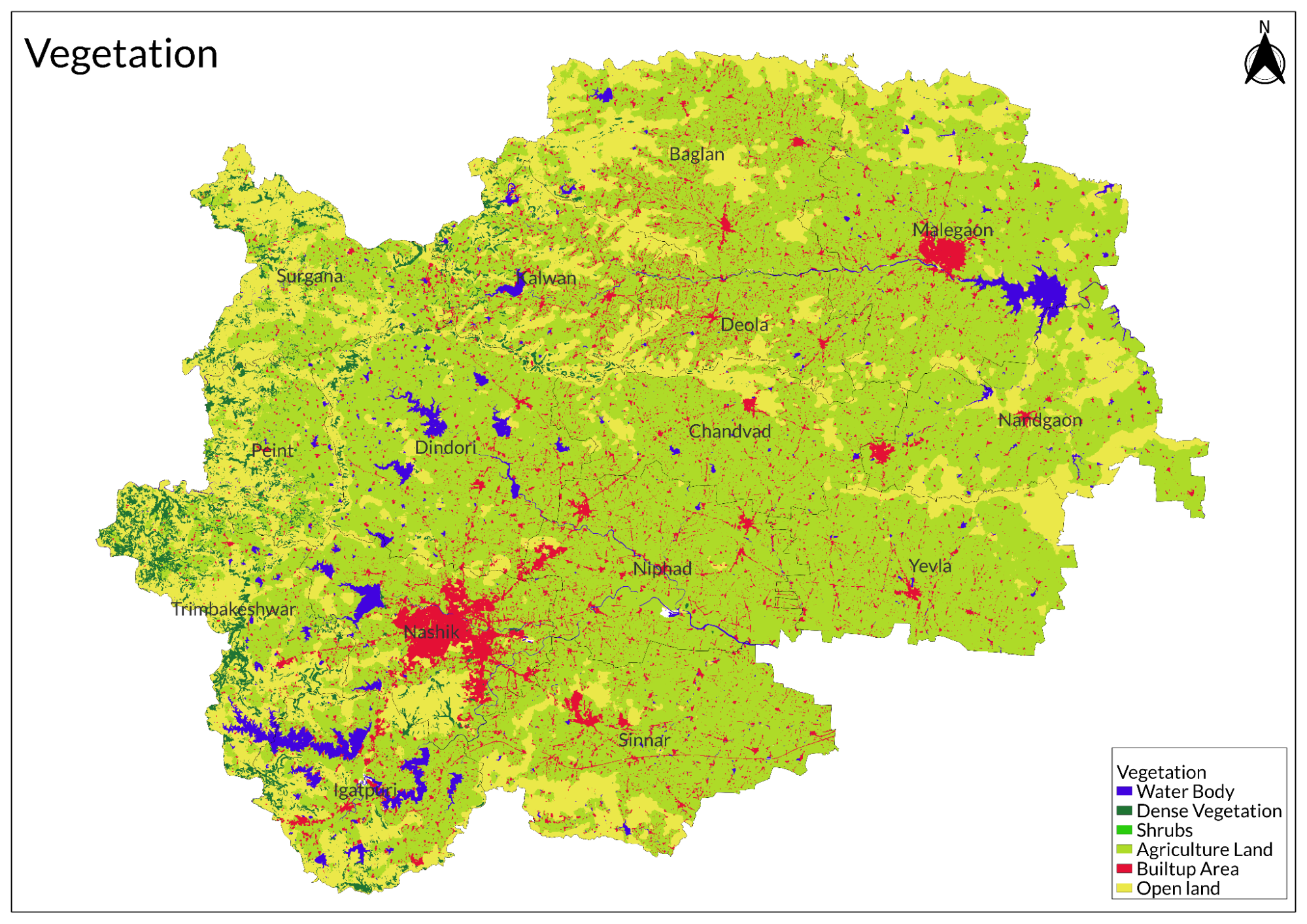
Land Use
Environmental Concerns
Deforestation
Deforestation in Nashik, Maharashtra, has become a pressing concern due to various factors, including illegal logging (as evidenced in April 2022 when significant tree felling occurred in Igatpuri taluka, affecting ancient banyan, Jamun, mango, teak, and medicinal trees), agricultural expansion (both small-scale and large-scale farming), the harvesting of raw materials, urban development projects (such as the June 2024 Nashik Municipal Corporation proposal to remove 17 mature trees along Gangapur Road, which prompted environmental advocacy for alternative safety measures), mining operations that clear forest areas for infrastructure, and the impact of livestock grazing that further diminishes the region's green cover.
Water Pollution
Nashik is grappling with severe water pollution issues that threaten both public health and the environment, with major concerns including sewage contamination in rivers (particularly the Godavari River suffering from industrial and domestic effluents), the disposal of domestic waste through nallas in unsewered areas (significantly impacting downstream crop yields), inadequate sewage treatment facilities (notably the absence of a common effluent treatment plant for industrial estates), insufficient stormwater management due to limited drainage infrastructure, groundwater pollution (especially in the Nashik MIDC area where industrial activities have rendered water sources undrinkable), and the alarming identification of 160 contaminated drinking water sources in rural areas by the Nashik Zilla Parishad health department, all of which highlight the urgent need for improved waste management practices and infrastructure development to address these critical challenges effectively.
Water Scarcity
Nashik, Maharashtra, is experiencing a severe water scarcity crisis due to poor monsoon rainfall, an unprecedented heat wave, and declining water levels in local dams. The district received only 70% of its average rainfall last year, creating drought-like conditions that have left many rural wells dry. The Naga-Sakya dam, the primary water source, has seen a significant drop in water levels. In response, district officials have deployed more water tankers, with 359 villages now relying on tanker deliveries. However, water quality remains a concern, with many supplies contaminated and unsafe for consumption.
The crisis has forced villagers to take extreme measures, such as women in Cholmukh village risking their lives by descending into deep wells to collect water from puddles. Many walk long distances in extreme heat to access limited supplies. The crisis has created both water shortages and health risks. The poor monsoon has also reduced water percolation, severely impacting agricultural productivity, leaving farmers struggling with insufficient irrigation.
Climate Change Vulnerability
Nashik faces increasing climate risks, including extreme heat, air pollution, rainfall variability, waterlogging, and groundwater depletion, as outlined in a Climate Action Plan (CAP) report by the Nashik Municipal Corporation (NMC) and the World Resource Institute (WRI) India. Since 2007, the city has recorded over 100 extreme heat wave days, with slum areas most affected. As of 2021, 40% of the population is exposed to land surface temperatures above 32°C, 23% live in waterlogging-prone areas, and 8.9% face both high temperatures and waterlogging, heightening health risks.
Air pollution in Nashik exceeds normal thresholds, driven by industrial activities (37%), unpaved road dust (33%), construction (13%), and vehicles along with paved road dust (7%). The city has also seen an increase in pre-monsoon rainfall, contributing to waterlogging. Overuse of water resources has led to high levels of water stress, further straining Nashik's environmental sustainability.
Conservation efforts/protests
Protests against Tata Power’s 100 MW Solar Power Plant
Farmers in Nashik's Nandgaon taluka are protesting Tata Power's proposed 100 MW solar plant, fearing it will disrupt agriculture and threaten their livelihoods by converting essential farmland for industrial use. Their concerns reflect a broader trend of environmental activism in the region, where communities are increasingly resisting projects that impact land and resources. As renewable energy demand grows, conflicts between agriculture and energy development are becoming more frequent. Protesters are urging authorities to relocate the project to a non-agricultural site.
Human chain to protest against the concretization of the ghats
Environmentalists in Nashik organized a human chain to protest against the concretization of the ghats, highlighting concerns that ongoing construction activities could lead to significant environmental degradation, disrupt local ecosystems, and harm the natural beauty of the area that is vital for the region's ecological balance and cultural heritage. The human chain serves as a visual demonstration of community opposition to these developments, with activists arguing that the concrete structures threaten not only the traditional use of ghats for religious and cultural practices but also their crucial role in maintaining water quality and supporting biodiversity, all while aiming to raise awareness about the importance of preserving these natural spaces.
Green Buffer Zone
In response to protests against a construction and demolition (C&D) waste plant in the area, city officials have announced plans to create a green buffer zone around the facility. The decision comes after community members expressed their dissatisfaction with the potential pollution and health risks associated with the C&D plant. The initiative aims to mitigate the impact of the plant on local residents and the environment by establishing a protective area filled with vegetation. By implementing a green buffer zone, Nashik aims to enhance air quality and provide a natural barrier that can help absorb pollutants, ultimately improving the living conditions for nearby residents.
Seaplane Services
A successful landing of a seaplane in Nashik had ignited significant protests from environmental activists, who are deeply concerned about the implications of such developments for the local ecosystem, arguing that introducing seaplane services could disrupt the delicate balance of the region's natural environment, which is essential for maintaining biodiversity and supporting local livelihoods. The activists emphasize that while the seaplane initiative may be framed as a step towards boosting tourism and economic growth, it poses serious risks to the environment, including increased noise pollution, disturbances to wildlife, and degradation of natural landscapes in the ghats and surrounding areas that are not only important for their scenic beauty but also play a crucial role in water conservation and habitat preservation, leading them to advocate for a more sustainable approach to development that prioritizes ecological integrity over short-term economic gains.
Environmental NGO’s
CERE (Centre for Environmental Research and Education)
CERE focuses on climate change awareness and energy conservation. They conduct training sessions on renewable energy, collaborate with schools and industries to implement green practices, and promote sustainable lifestyles through outreach programs.
Eco Club Nashik
Focusing on environmental education and waste management, the organisation conducts workshops on waste segregation and recycling. They educate students and community members about conservation practices and organize cleanliness drives in public spaces and heritage areas.
Green Vision Nashik
This NGO focuses on enhancing urban greenery and promoting environmental awareness. They organize tree plantation drives throughout Nashik, engage with schools and communities to raise awareness about environmental issues, and advocate for the protection of green spaces in urban areas.
Nisarg Seva Samiti
This organization is involved in reforestation efforts and water resource management. They lead afforestation projects in deforested areas of Nashik, initiate water conservation techniques like check dams and rainwater harvesting, and educate farmers on sustainable irrigation practices.
Paryavaran Dakshata Mandal (PDM)
This NGO emphasizes sustainable development and biodiversity conservation. PDM engages citizens in protecting Nashik’s biodiversity through advocacy, workshops on organic farming, and promoting eco-friendly practices in both urban and rural settings.
Sahyadri Nisarga Mitra (SNM)
Focusing on wildlife conservation, SNM works to protect endangered species, particularly in the Western Ghats. They promote eco-tourism and conduct awareness campaigns to educate the public about wildlife conservation while also conducting surveys on local biodiversity.
Save Godavari Foundation
Dedicated to river conservation, this organization works on rejuvenating and cleaning the Godavari River. They create awareness about the negative impacts of pollution, particularly from idol immersions during festivals, and promote eco-friendly practices for religious rituals.
Graphs
Water
Climate & Atmosphere
Forests & Ecology
Human Footprint
Sources
About District: Nashik District. 2025, March 12. Nashik District; Government of Maharashtra.https://nashik.gov.in/en/about-district/
After C&D plant protests, Nashik to create green buffer zone. 2022, November 29. ConstructionWorld.In.https://www.constructionworld.in/urban-infra…
Botekar, A. 2024, August 17. 160 sources of contaminated water identified in rural Nashik. The Times of India.https://timesofindia.indiatimes.com/city/nas…
Ghorpade, M. P., Gupta, A., & Kujur, A. 2024, July. Farmers lead protest against Tata Power’s 100 MW Solar Power Plant in Nashik’s Nandgaon Taluka. Land Watch Conflict.https://www.landconflictwatch.org/conflicts/…
Illegal logging continues in Igatpuri. 2022, April 18. Deshdoot Digital.https://deshdoot.com/illegal-logging-continu…
Khairnar, D. N. 2009. Biodiversity in Wild Fauna of North Sahyadri in Nashik District, Maharashtra. Nature Environment and Pollution Technology, 8(4), 769–772.https://neptjournal.com/upload-images/NL-1-2…
Nashik: Sea-plane lands successfully; green activists protest. 2014, November 3. The Economic Times.https://economictimes.indiatimes.com/news/po…
Nikale, P. 2024, April 18. Water Scarcity Grips New Colonies In Nashik. Free Press Journal.https://www.freepressjournal.in/pune/water-s…
Pawar, T. 2024, February 10. Heat, air pollution among four climate change risks for Nashik. The Times of India.https://timesofindia.indiatimes.com/city/nas…
Sarkar, S. 2014, July 6. Environmentalists form human chain to protest concretisation of ghats. The Times of India.https://timesofindia.indiatimes.com/city/nas…
Last updated on 6 November 2025. Help us improve the information on this page by clicking on suggest edits or writing to us.