Contents
- Physical Features
- Climate
- Geology
- Soil
- Minerals
- Rivers
- Wild Animals
- Birds
- Snakes
- Forest Reserves
- Great Indian Bustard Wildlife Sanctuary
- Land Use
- Environmental Concerns
- Water Scarcity
- Deforestation
- Conservation Efforts/Protests
- Climate Action Plan for Sustainable and Resilient Development
- Wetland Conservation
- Graphs
- Water
- A. Rainfall (Yearly)
- B. Rainfall (Monthly)
- C. Evapotranspiration Potential vs Actual Numbers (Yearly)
- D. Annual Runoff
- E. Runoff (Monthly)
- F. Water Deficit (Yearly)
- G. Water Deficit (Monthly)
- H. Soil Moisture (Yearly)
- I. Seasonal Groundwater Levels: Bore Wells
- J. Seasonal Groundwater Levels: Dug Wells
- Climate & Atmosphere
- A. Maximum Temperature (Yearly)
- B. Maximum Temperature (Monthly)
- C. Minimum Temperature (Yearly)
- D. Minimum Temperature (Monthly)
- E. Wind Speed (Yearly)
- F. Wind Speed (Monthly)
- G. Relative Humidity
- Human Footprint
- A. Nighttime Lights
- Sources
SOLAPUR
Environment
Last updated on 6 November 2025. Help us improve the information on this page by clicking on suggest edits or writing to us.
Solapur district, located in southeastern Maharashtra, is characterized by its semi-arid landscape, which is interspersed with natural areas such as the Great Indian Bustard Sanctuary and wetlands like Ekrukh Lake.
Physical Features
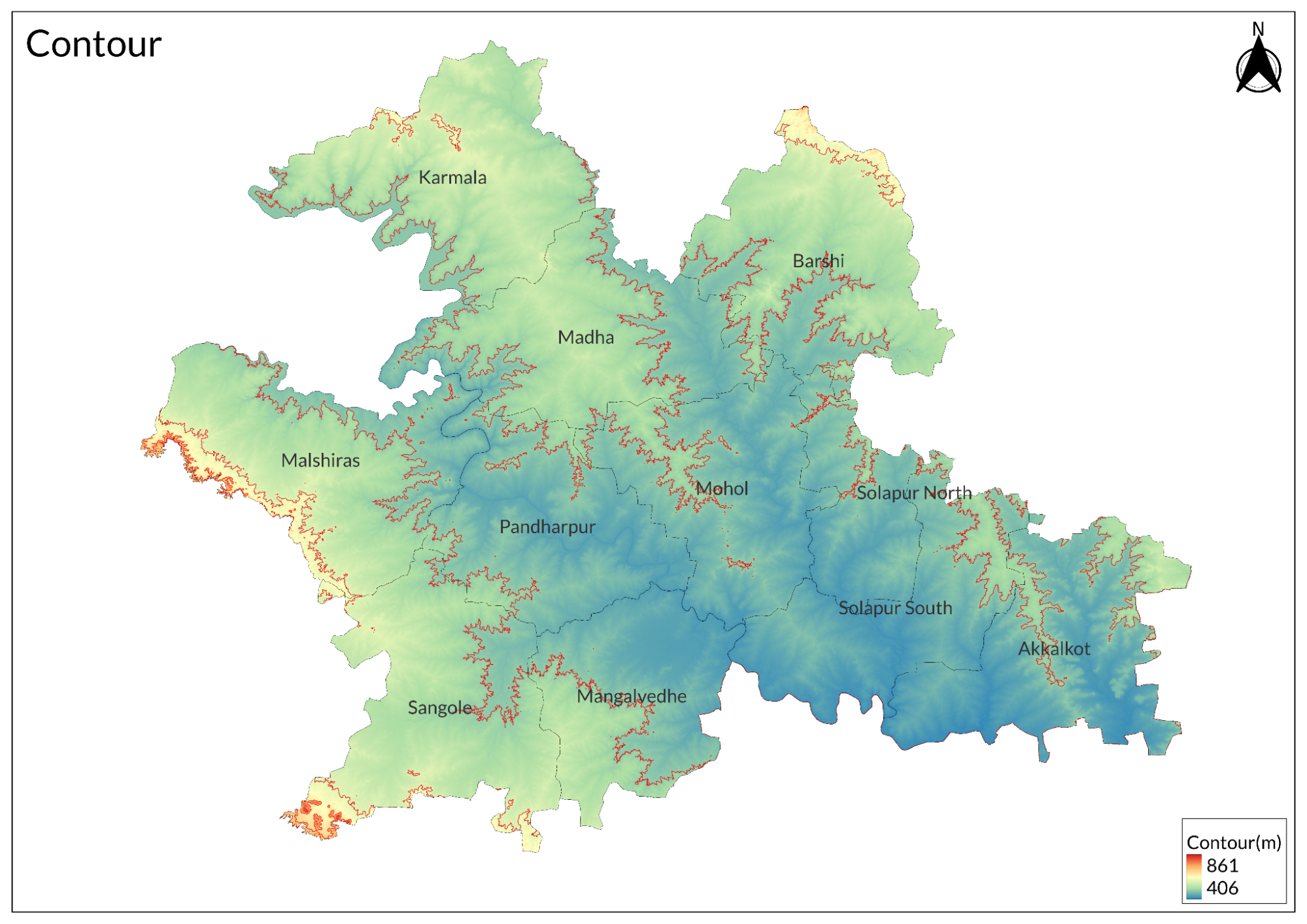
The district of Solapur is located in the southeastern region of Maharashtra, India. It is situated at an elevation of 457 meters above mean sea level and covers an area of 14,844 square kilometers. The main city of Solapur lies along the banks of the Bhima River. The district is bordered to the north by Ahmednagar and Osmanabad districts, to the east by Osmanabad and Gulbarga (Karnataka State) districts, to the south by Sangli and Bijapur (Karnataka State), and to the west by Satara and Pune districts. The district is divided into 11 tehsils.
There are no significant hills in the district, except for some spurs of the Balaghat range in the north, which extend south for a few kilometers. The Bhima River, a tributary of the Krishna River, along with its two major tributaries, the Nira and Sina, drains the district. The Sina River flows through the center of Solapur, while the Bhima River drains from the center and forms the western border of the district. Additionally, there are a few scattered hills in the Karmala, Madha, and Malshiras tehsils. Generally, the district features flat or undulating terrain. The lowland and small separate hills in Karmala and Madha tehsils serve as a watershed between the Bhima and Sina rivers.
The Bhima River, also known as the Chandrabhaga River, is considered a holy river; the Temple of Vitthal is located on its banks in Pandharpur Town. The Akkalkot Plains, located in the eastern part of the district, are open rolling plains at an elevation of 400 meters that are treeless, with numerous wells providing water. The black and mixed murum soils support the cultivation of sugarcane, rice, and rabi jowar through budki irrigation. These geographical features significantly influence human settlements, agricultural practices, and cultural landscapes throughout Solapur.
Climate
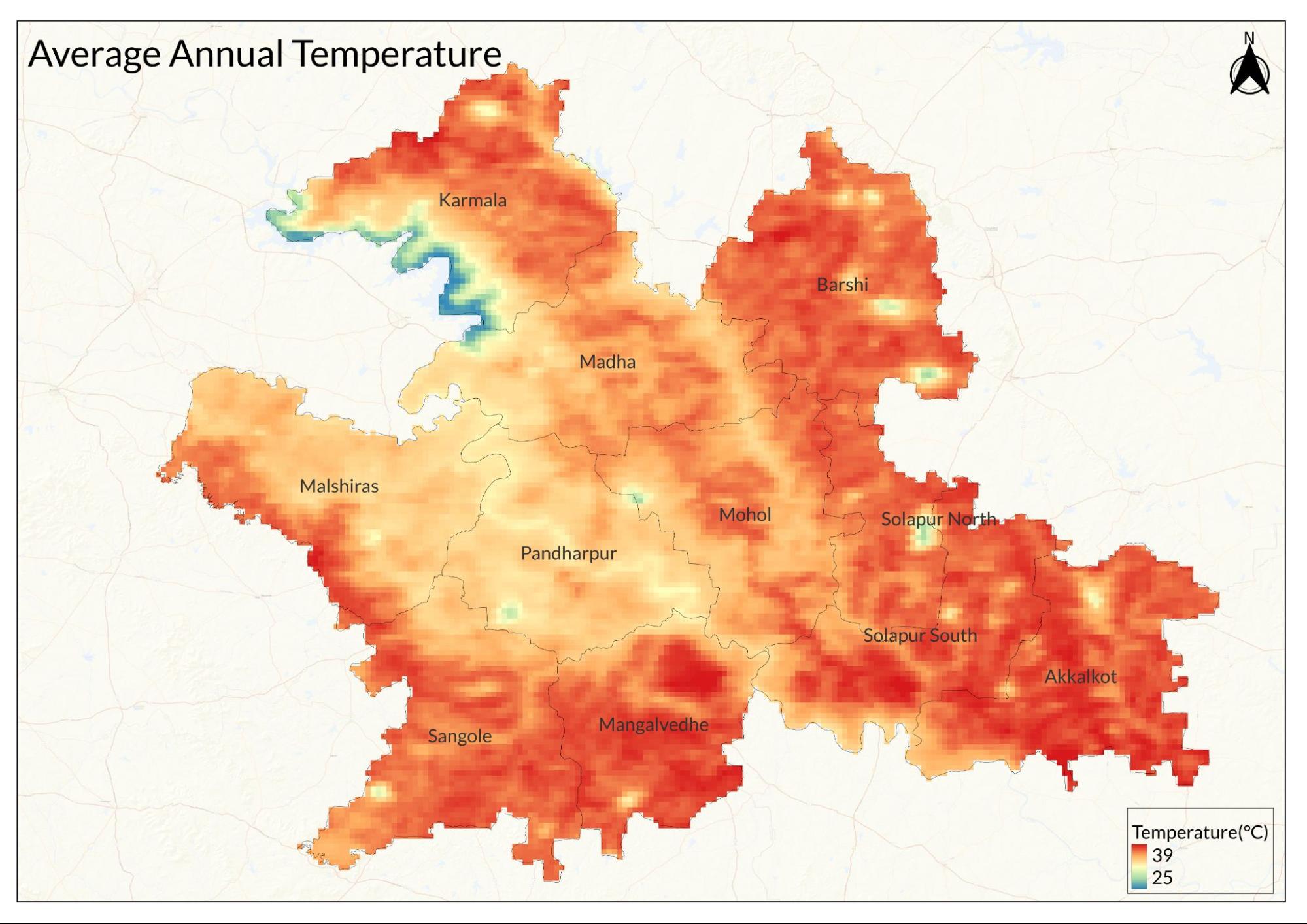
The district experiences dry weather throughout the year, except during the monsoon season. The average temperature in the district ranges from 24°C to 30°C. The winter season lasts from December to February, with minimum temperatures ranging between 18°C and 21°C. The summer season extends from March to June, with the highest temperatures reaching about 45°C in May.
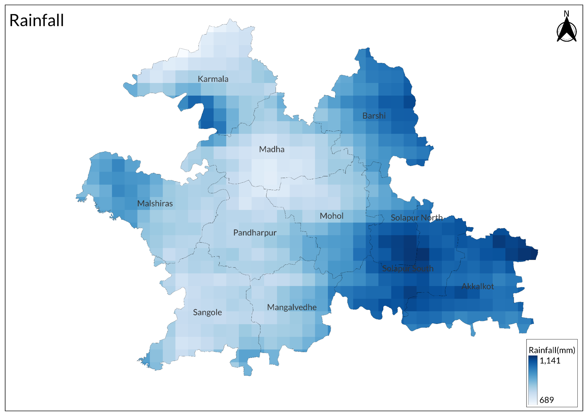
The monsoon season occurs from June to September, during which the district receives an average annual rainfall of 561.78 mm. Following the monsoon, the post-monsoon season lasts from October to November, with an average rainfall of 194 mm.
Geology
The Solapur district is primarily covered by Deccan Basalt soil. The black cotton soil is prevalent throughout the district, formed by the weathering of the Deccan trap. Calcareous kankar and nodules are commonly associated with these soils.
Soil
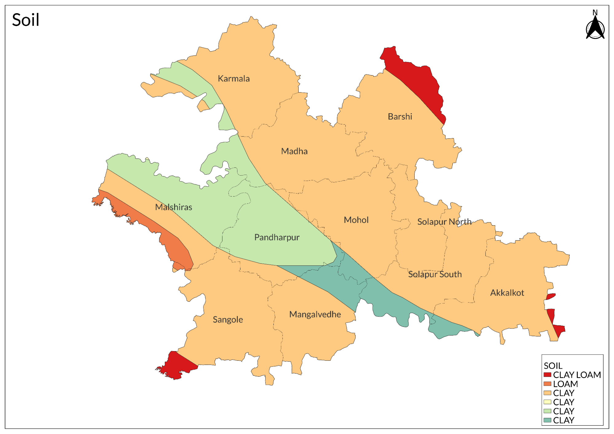
The soils in the district can be classified mainly based on depth, with medium deep soils (22.5 to 90 cm) dominating the soil profile, covering 45 percent of the area. Additionally, about 25 percent of the area consists of deep soils, which are more than 90 cm in depth, while approximately 30 percent is under shallow soils. The geographical foundation of the soils in Solapur district is derived from Deccan basalt flows, underlain by partially decomposed basaltic rock locally known as "Murum."
Due to the almost complete absence of leaching, these soils are base-saturated, with exchangeable calcium being the predominant cation. The free lime content is relatively high, ranging from 5 to 10 percent. The soils exhibit varying degrees of erosion and truncated profiles. Generally, they are clay in texture, predominantly composed of montmorillonite clay minerals. This clay content causes the soils to swell and shrink upon wetting and drying, leading to the development of cracks after the rainy season.
Minerals
No minerals of economic importance have been reported from the district. The hard and compact basalts are locally used as building materials and for road construction.
Rivers
The entire district is drained by the Bhima River and its tributaries. The main rivers of the district are the Bhima, with its right-bank tributaries being the Nira and the Man, and its left-bank tributary being the Sina. The Bhima and the Sina flow in a roughly south-easterly direction, while the Nira flows east and the Man flows north-easterly. During the dry season, all these rivers are crossable, including the main river, the Bhima. However, during the peak of the southwest monsoon season, not only the main streams but also the seasonal feeder streams experience flooding, although this lasts for a short period.
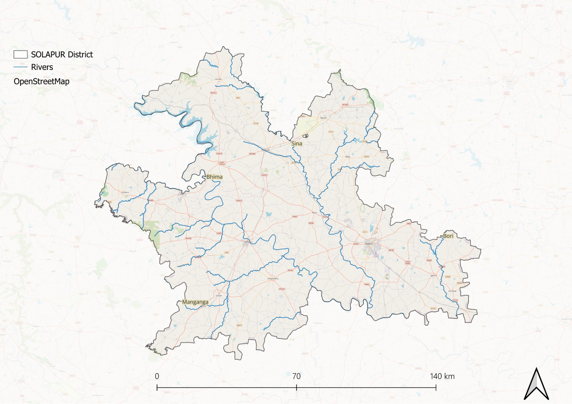
The Bhima River, also known as the Chandrabhaga River, is considered a holy river in Solapur. It drains the central parts of the district, covering a significant portion of Karmala, Madha, Malshiras, Pandharpur, Mangalwedha, Mohol, and Solapur tehsils. The river is one of the main feeders of the Krishna River; it rises in the north near Bhimashankar in Pune district and flows southeast through Pune, Ahmednagar, Solapur, and Bijapur districts before joining the Krishna River about 25 km north of Raichur. It enters Solapur district near the village of Jinti in Karmala taluka and continues southeast until it exits the district near Hilli village in Akkalkot tehsil. The river has an overall length of 289 km within the district.
For approximately 110 km of its winding course, the river separates Karmala on the left from Indapur in Pune district on the right; for about 10 km, it separates Madha on the left from Malshiras on the right; for about 34 km, it separates Pandharpur on the left from Malshiras on the right; and for about 65 km, it passes through Pandharpur, separating Solapur and Akkalkot on the left from Bijapur on the right. The course of the river throughout the district is winding, with a general south-easterly direction. Near the center of Pandharpur tehsil, it flows to the right of Pandharpur, one of the holiest places in the district.
The three major tributaries of the Bhima that drain into the district are the Nira River from the right near Sangam village in Malshiras tehsil to the west, the Man River also from the right near Sarkoli about 17 km southeast of Pandharpur in southern Solapur district, and the Sina River from the left about 17 km southwest in South Solapur taluka along the southern boundary of the district. The waters of Bhima are minimally used for irrigation.
The Bori River is a left-bank tributary of the Bhima that rises on the south-facing scarp lands of Dharashiv district near Tuljapur and flows southward into eastern Akkalkot tehsil. Harni is one of its tributaries. The Bori has a flow of 50 km through this district.
The Bhogawati River is a large tributary of the Sina that rises in the south-facing scarps of the Balaghat range in northeastern Barshi taluka. After a south-westerly course of about 65 km through Barshi and Madha, it falls into the Sina about 7 km north of Mohol. The Bhend is a small tributary on the right bank of the Sina that rises near Kem in Karmala and flows into the Sina just north of Undargaon village.
Wild Animals
In the scrub forests of Barshi and Malshiras tehsil, wildlife is sparsely found. Panthers are rarely seen, while jackals, hyenas, and wild cats are occasionally spotted. Among these, the chinkara, blackbuck, and hare inhabit the scrub forests and grasslands near Yedshi and Ramling. Wild pigs are also plentiful in the district. The echidna, locally known as salya, is also found in the area.
Birds
Common birds in the district include peafowl, grey and painted partridges, quails, green pigeons, and ducks. The great Indian bustard is found in large numbers in the bird sanctuary.
Snakes
Snakes are abundant in the district and are commonly found in agricultural land and near human settlements. The variety of snake species in the district is divided into two groups: poisonous and non-poisonous. Poisonous snakes include nag (cobra), manyar, ghonas (kandar), phursa, coral snakes, and green pit vipers. Non-poisonous species include daud, dutondya, ajgar (python), pharad, dukrya ghonas, rat snake, nagin, songtya, cat snake, sarptoli, gavtya, kavya, wolf snake, pandivad, and naneti snake.
Forest Reserves
Great Indian Bustard Wildlife Sanctuary
Established in 1979, the Great Indian Bustard Wildlife Sanctuary, also known as the Jawaharlal Nehru Bustard Sanctuary, is an important wildlife reserve in Maharashtra. It is famous for protecting the rare Great Indian Bustard and is considered one of the best wildlife sanctuaries in the state. The best time to visit is from September to February. Located 22 kilometers from Solapur, Maharashtra, the sanctuary currently does not offer safari facilities. It is 251 kilometers from Pune and 398 kilometers from Mumbai.
The late Dr. Salim Ali, a well-known ornithologist in India, also visited the sanctuary for research. Maharashtra is one of six states in India where Great Indian Bustards can still be found, along with Gujarat, Rajasthan, Karnataka, Andhra Pradesh, and Madhya Pradesh.
The sanctuary originally covered an area of 8,469 square kilometers and includes parts of North Solapur, Madha, Mohol, and Karmala talukas in Solapur district, as well as Karjat, Shrigonda, and Newasa talukas in Ahmednagar district. The headquarters of the sanctuary are located in Nannaj and Rehekuri.
The sanctuary's unique landscape attracts many visitors. In addition to the Great Indian Bustard, you can find various bird species such as the Indian Courser, Chestnut-bellied Sandgrouse, Southern Gray Shrike, Eurasian Thick-knee, Bay-backed Shrike, Indian Bush Lark, partridges, and Bonelli's Eagle. The sanctuary also has populations of Blackbuck, wolves, Indian foxes, and jackals.
Entry permits to the Great Indian Bustard Sanctuary can be obtained from the forest office in Nannaj. Although there are no safari facilities provided by the forest authority, visitors can use their vehicles in designated areas of the park. However, free movement is restricted in the core area; entry is allowed only up to a hut located 100 meters from the gate. A watchtower near the entrance offers a great view for observing wildlife. There is also a forest guest house with limited accommodation available. The best time to explore the sanctuary and see many birds is between September and February.
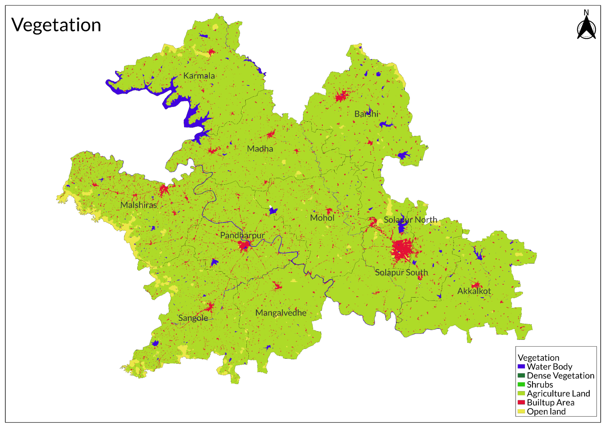
Land Use
Environmental Concerns
Water Scarcity
Water scarcity and depletion in Solapur district have become increasingly pressing issues, exacerbated by limited and erratic rainfall. Historically, communities in the region relied on traditional water harvesting methods, such as wells, tanks, and reservoirs, to manage the arid conditions. However, urbanization and population growth have significantly increased the water demand, placing immense pressure on existing resources. Solapur's semi-arid climate, characterized by high temperatures and unpredictable rainfall patterns, further intensifies the challenges of water scarcity. The limited availability of surface water, combined with an over-reliance on groundwater extraction, has strained the district’s water resources. Rapid population growth, particularly in urban areas, has led to heightened demand for domestic, industrial, and agricultural water use. Unfortunately, the current water infrastructure is inadequate to meet this escalating demand.
Intensive agricultural practices, including excessive groundwater pumping for irrigation, have contributed significantly to the depletion of water resources. The lack of sustainable water management practices in agriculture has worsened the situation. Additionally, inadequate water storage facilities, outdated distribution networks, and losses within the water supply chain have led to inefficiencies in managing available water.
Various initiatives have been undertaken to address these issues. Awareness campaigns and community programs aimed at promoting water conservation practices have been implemented. Rainwater harvesting projects have been introduced to capture and store rainwater for both domestic and agricultural use, to replenish groundwater levels. Efforts to recharge groundwater through methods such as percolation tanks and artificial recharge structures have also been initiated.
Government schemes like Atal Bhujal Yojana, Jal Jeevan Mission, Jalyukt Shivar, and MGNREGA focus on enhancing water supply infrastructure by drilling borewells, constructing storage tanks, and developing distribution networks. However, these efforts have faced challenges such as inadequate funding, lack of community participation, and changing climatic conditions that affect their effectiveness.
The situation has reached a critical point where residents frequently experience severe water shortages. Reports indicate that many areas receive water only once every few days due to dwindling levels in key sources like the Ujani dam. Villagers often resort to collecting water from tankers that arrive infrequently, leading to struggles for necessities.
Deforestation
Historically, the forest area in Solapur has been under pressure from timber extraction for domestic use and indiscriminate grazing practices. These activities have contributed to the degradation of forest ecosystems, resulting in a loss of biodiversity and disruption of local habitats. The situation has been further exacerbated by the lack of effective forest management practices and the enforcement of regulations aimed at conserving forest resources. According to the Forest Survey of India, as of 2019, Solapur district had very limited forest cover, with only 49.67 square kilometers classified as forested area, which represents merely 0.33% of the total geographical area.
Conservation Efforts/Protests
Climate Action Plan for Sustainable and Resilient Development
The Solapur Municipal Corporation (SMC) launched its first-ever Climate Action Plan (CAP) as part of Maharashtra's broader initiative to promote sustainable development and climate resilience across 43 cities and urban clusters in the state. Developed with technical support from WRI India, the CAP aimed to foster low-carbon, inclusive development by conserving natural resources and building resilient systems for the community, environment, and businesses.
The Solapur CAP served as a roadmap for the city's commitment to combat climate change and enhance its resilience. It focused on two primary strategies: adaptation, which aimed to improve the city's ability to cope with the impacts of climate change, and mitigation, which involved assessing current and future greenhouse gas emissions while developing sector-specific strategies to reduce these emissions.
Extensive stakeholder consultations played a crucial role in identifying six priority sectors for the city: Urban Heat and Greening, Sustainable Mobility, Water Resource Management, Air Quality, Sustainable Municipal Solid Waste Management, and Energy and Buildings. The CAP outlined specific goals, actions, and targets for each of these sectors. Additionally, a governance framework was established to ensure effective monitoring, evaluation, and reporting of the plan's progress. A proposed Environment and Climate Action Cell was set to be established within SMC to manage data, conduct research, coordinate with other agencies, and monitor outcomes.
The launch event was attended by key officials, including the Hon’ble Municipal Commissioner Smt. Sheetal Teli-Ugale (IAS), who expressed her pleasure at unveiling the CAP. She highlighted that this marked the first time a detailed Vulnerability Assessment and greenhouse gas emissions inventory had been prepared for Solapur City in alignment with national and global commitments. Smt. Teli-Ugale emphasized that SMC would focus on implementing various priority actions recommended under the CAP.
Other notable attendees included Additional Municipal Commissioners and representatives from WRI India. Shri Abhijit Ghorpade, Director of the Maharashtra State Climate Action Cell, praised Solapur for leading tier-2 cities in formulating its climate action plan. He thanked the Municipal Commissioner and her team for their efforts alongside WRI India's support. Madhav Pai, CEO of WRI India, remarked on the unique opportunity Solapur had to lead in climate action through sustainable development.
Wetland Conservation
Wetland conservation initiatives in Solapur district, Maharashtra, have centered on restoring the physical, chemical, and biological integrity of various wetland ecosystems. Key efforts include rejuvenating lakes and rivers and constructing water harvesting structures to improve water availability.
A notable example is the restoration of Ekrukh Lake, carried out with support from the International Development Research Centre (IDRC) and ICLEI South Asia through the use of constructed wetlands. Similarly, the revitalization of Vitthal Ganga was funded by the state government in collaboration with the NAAM Foundation. The Tata Trust also contributed to restoring a 42-kilometer stretch of the Kasal Ganga Odha river.
Graphs
Water
Climate & Atmosphere
Human Footprint
Sources
Forest Survey of India (FSI). 2019. India State of Forest Report - Maharashtra (Volume II). Ministry of Environment, Forest and Climate Change, Government of India.https://fsi.nic.in/isfr19/vol2/isfr-2019-vol…
Government of India - Abhinav Pahal. 2023. Water Conservation Initiative of Solapur District.Abhinav Pahal Initiative, Government of India.https://abhinavpahal.nic.in/uploads/LN35y7kg…
International Journal of Innovative Science, Engineering & Technology (IJISET). 2023. Study on Environmental and Water Management in Maharashtra. IJISET, Vol. 11, Issue 1.https://ijiset.com/vol11/v11s1/IJISET_V11_I0…
Kumbhar, Digvijay. 2020. Status of Some Selected Wetlands of Ujani Reservoir of Solapur District, Maharashtra, India. ResearchGate Publication.https://www.researchgate.net/profile/Digvija…
World Resources Institute (WRI) India. 2023. Solapur Launches Its First-Ever Climate Action Plan for Sustainable and Resilient Development. WRI India News & Reports.https://wri-india.org/news/solapur-launches-…
Last updated on 6 November 2025. Help us improve the information on this page by clicking on suggest edits or writing to us.