Contents
- Physical Features
- Climate
- Geology
- Soil
- Minerals
- Rivers
- Dams and Lakes
- Botany
- Wild Animals
- Birds
- Forest Reserves
- The Bor Wildlife Sanctuary
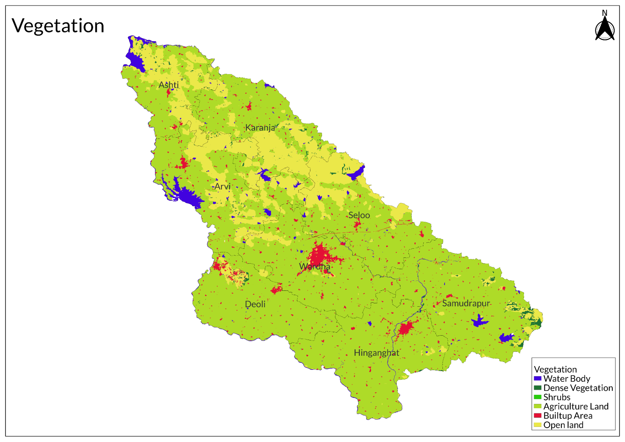
- Land Use
- Environmental Concerns
- Water Scarcity
- Water Pollution
- Industrial Pollution
- Conservation Efforts
- Water Conservation
- Environmental NGOs
- Chetana Vikas
- Graphs
- Water
- A. Rainfall (Yearly)
- B. Rainfall (Monthly)
- C. No. of Rainy Days in the Year (Taluka-wise)
- D. Evapotranspiration Potential vs Actual Numbers (Yearly)
- E. Annual Runoff
- F. Runoff (Monthly)
- G. Water Deficit (Yearly)
- H. Water Deficit (Monthly)
- I. Soil Moisture (Yearly)
- J. Seasonal Groundwater Levels: Bore Wells
- K. Seasonal Groundwater Levels: Dug Wells
- Climate & Atmosphere
- A. Maximum Temperature (Yearly)
- B. Maximum Temperature (Monthly)
- C. Minimum Temperature (Yearly)
- D. Minimum Temperature (Monthly)
- E. Wind Speed (Yearly)
- F. Wind Speed (Monthly)
- G. Relative Humidity
- Forests & Ecology
- A. Forest Area
- B. Forest Area (Filter by Density)
- C. Wildlife Projects (Area and Expenses)
- Human Footprint
- A. Nighttime Lights
- Sources
WARDHA
Environment
Last updated on 6 November 2025. Help us improve the information on this page by clicking on suggest edits or writing to us.
Wardha district, part of the Nagpur plain, features rugged hills, fertile plains, and the Wardha River shaping its landscape. With a tropical climate, it supports agriculture, mainly cotton, soybean, and pigeon pea. Geologically, it lies on the Deccan Plateau with basaltic rock and coal reserves. The district is home to Bor Wildlife Sanctuary and key water bodies like Upper Wardha and Bor Dams, aiding irrigation and conservation.
Physical Features
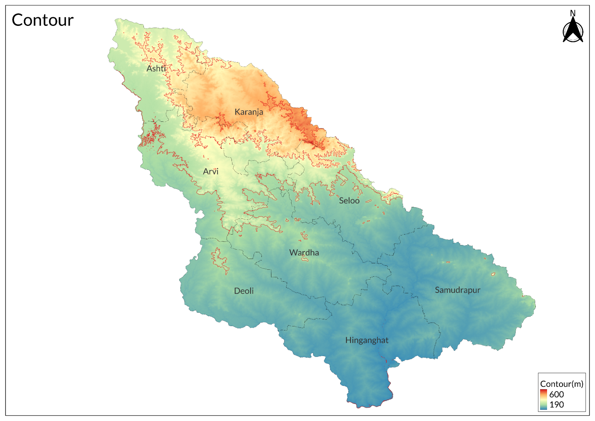
The Wardha district, located in the western part of the Nagpur plain, is bordered by the Satpura hills. Covering an area of 6,310 square kilometers and situated at an elevation of 234 meters above mean sea level, the district has a distinctive elongated shape along the banks of the Wardha River. The district's name is derived from this river, which historically defined its boundaries until it became separate from Nagpur district in 1862. The Wardha River delineates the northern, western, and southwestern edges of the district, while it is surrounded by Nagpur district to the northeast, Chandrapur to the southeast, Yavatmal to the southwest, and Amaravati to the northwest. The district is administratively divided into eight tahsils: Selu, Deoli, Hinganghat, Samudrapur, Arvi, Wardha, Karanja, and Ashti.
The Satpura range extends from the north to the southeast of Wardha district, characterized by rugged terrain with flat-topped hills composed of trap rock. During the monsoon season, these hills transform into grazing grounds for livestock. Regions like Ashti and Kondhali feature hills adorned with young teak trees and fertile valleys. The Wardha River flows westward while other rivers such as Dham and Bor flow southward across the district. The northern hills exhibit steep descents known as ghats that lead down to the river.
Approximately 25% of the district is hilly terrain, featuring notable peaks such as Garamsur (601 m), Nandgaon (536 m), Malegaon (309 m), and Gandhi Hill at 257 m—a tribute to Mahatma Gandhi, who lived in the district from 1936 until his death in 1948. The Kondhali and Thanegaon plateaus near Nagpur are relatively flat compared to other regions. Overall, Wardha's landscape ranges from rugged hills to fertile plains shaped by its geological features and seasonal weather patterns.
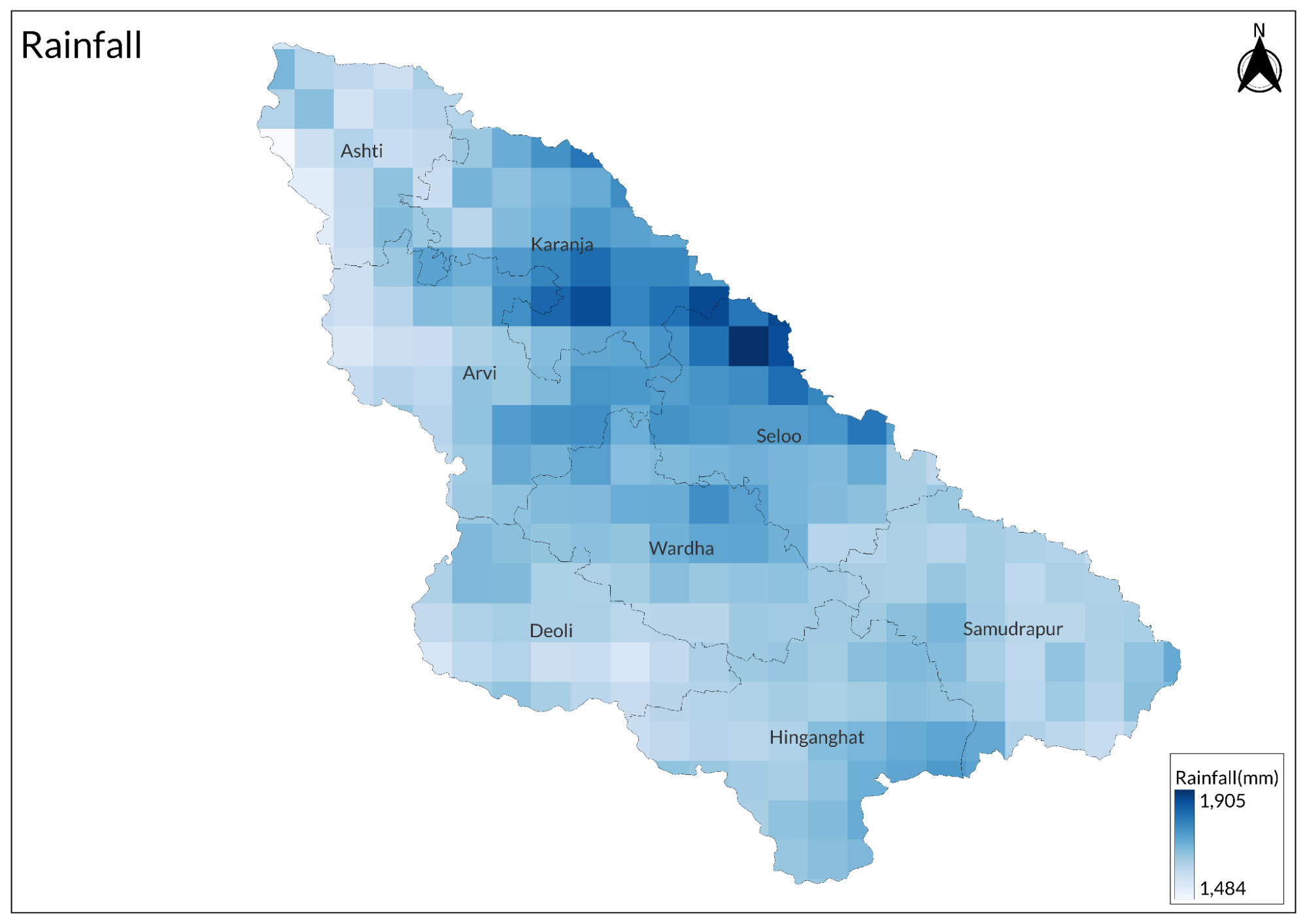
Wardha experiences a tropical climate with distinct seasons influenced by monsoon rains. The average annual rainfall ranges from 985 mm to 1,100 mm, contributing significantly to its agricultural viability. The economy of Wardha district is primarily agricultural. Key crops include soybean and pigeon pea, with cotton being a major cash crop occupying about one-third of cultivated land. Sugarcane cultivation is also increasing in certain talukas, alongside the production of oranges and bananas in select areas.
Climate
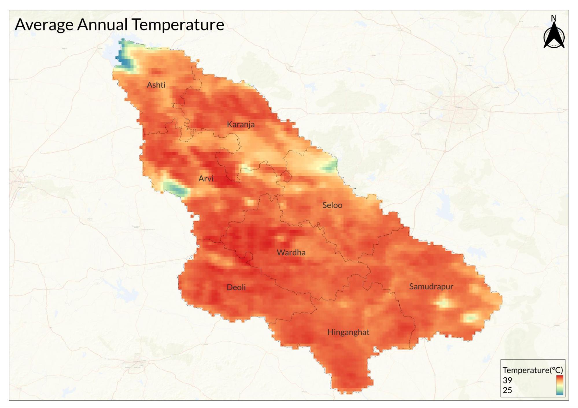
The District of Wardha has a dry and tropical wet climate for most of the year, with average temperatures ranging from 24.2°C to 34.15°C. The climate is characterized by a hot summer and general dryness throughout the year, except during the southwest monsoon season.
The year is divided into four distinct seasons. Winter lasts from December to February, with December being the coldest month, averaging a minimum temperature of 17°C. The summer season extends from March to mid-June, with May noted as the hottest month, reaching average maximum temperatures of 43°C. The monsoon season runs from late June to the first week of October, with July recognized as the wettest month, averaging 467 mm of precipitation. The remaining months of October and November constitute the post-monsoon season, which receives an average rainfall of 135 mm.
Rainfall patterns in Wardha consistently show an increase from the northwest to the southeast regions, as documented in both the revised Gazetteer of 1974 and the Survey of India. The district typically receives about 134.53 mm of precipitation annually and experiences around 116 rainy days each year.
Geology
Wardha district and its surroundings are predominantly characterized by flat-lying trap rock, which extends into the Deccan Plateau. This geological formation features layers of limestone, sandstone, and occasional fossils, contributing to the area's rich geological diversity. The landscape includes rolling plains and flat-topped hills, with terraced basaltic rock exposures that are typical of the region.
The geology of Wardha district primarily consists of Deccan Trap lava flows, with some patches of Gondwana formations and Lametas present along major river courses. The Deccan Traps cover approximately 95% of the area and are composed mainly of basaltic rocks. Additionally, alluvial deposits are found along the banks of the Wardha River and its tributaries, with thickness reported to be between 15 to 20 meters. The district's terrain is marked by three distinct landform types: structural, denudational, and fluvial, reflecting the complex interplay between geological processes over time.
Soil
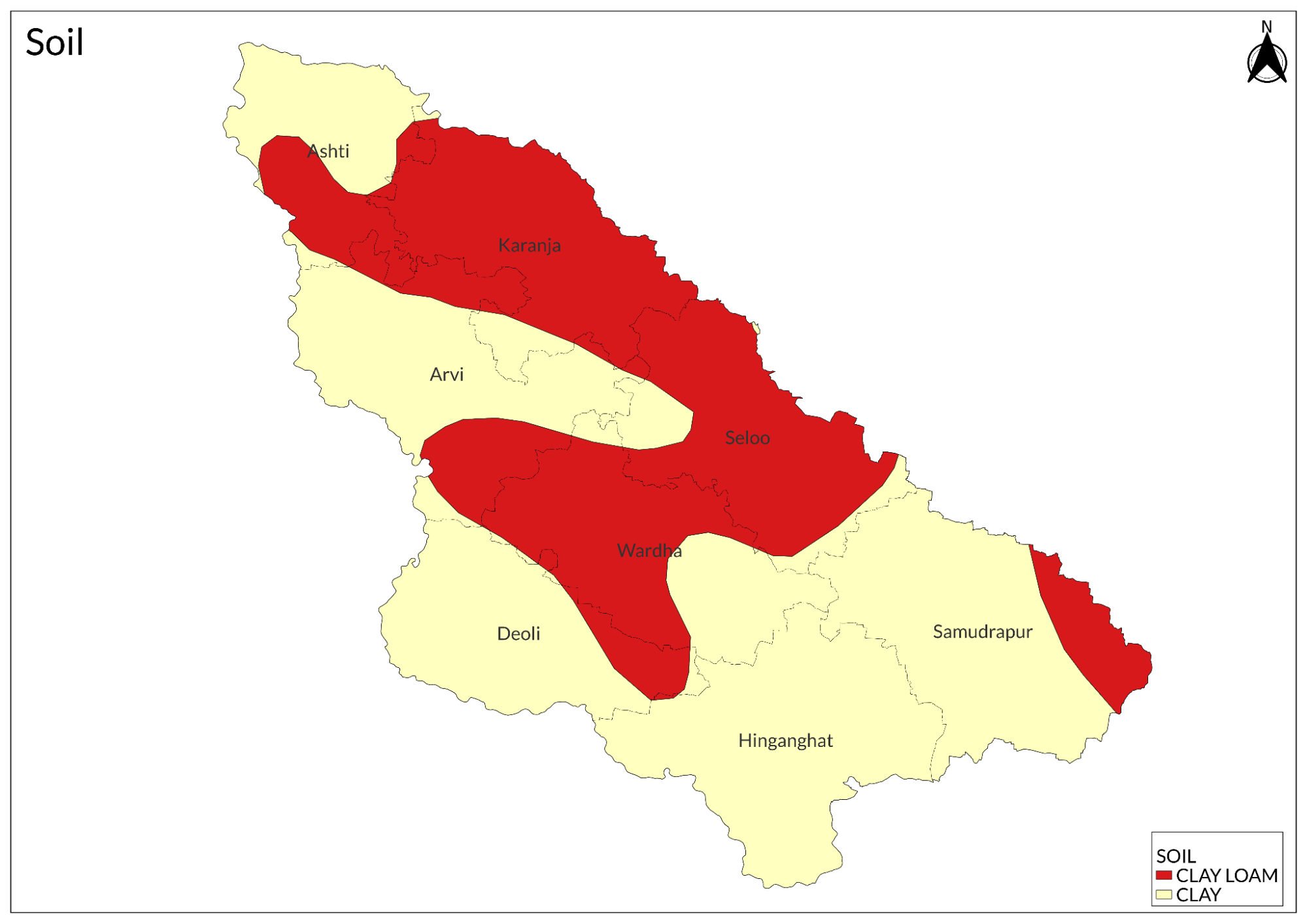
The soil type consists of recent to sub-recent alluvium plains deposited by the Wardha River and its tributaries. This fertile black cotton soil is up to two feet thick and has formed from the weathering of basalt and organic matter, often containing calcareous tufa or kankar, which is used in local construction.
Minerals
The district has limited mineral resources, primarily consisting of coal, with the Wardha Valley Coalfield being essential for power generation. This coalfield features 37 operational mines, producing approximately 59.5 million tonnes (MT) of coal annually. Despite this significant output, the district lacks other notable mineral resources, as confirmed by multiple sources indicating no major minerals aside from coal in the region.
Rivers
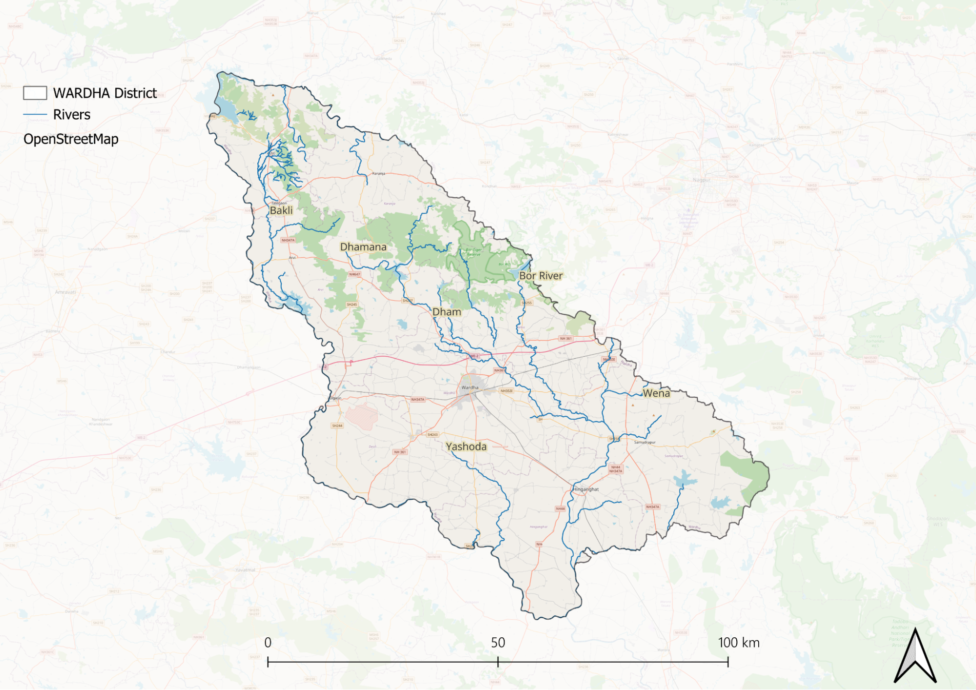
The Wardha River flows along three sides of the district, with its banks lined by rows of huge banyan trees that enhance the riverbank's beauty. Originating from the Multai Plateau in the Satpura Range, the Wardha flows along the northern and western borders of the district, providing a significant amount of water for agriculture and other purposes. Its rocky and deep bed transforms into a furious torrent during the rains but nearly dries up in the summer. At Pulgaon, a bridge constructed with fourteen girders spanning 19.5 meters serves as a popular tourist destination during the monsoon season. The Wardha’s principal tributary, the Wena, enters the district from Nagpur, passes by Hinganghat, and joins the Wardha at the southwestern corner of the district. The confluence of the Wardha and Wena rivers is near Dhiwri Pipri village and is known as Sangam Sawangi. The Bor and Dham rivers rise in the Arvi tahsil and flow southeast, uniting near Sakurdi village in Hinganghat before Dham joins the Wena above Mandgaon. The Yashoda River, which rises in the southwest of Arvi tahsil, flows near Deoli village and joins the Wardha near Kanholi village. The Pothra River, the largest left-bank tributary of the Wena, originates in the Girar hills, draining the eastern parts of Hinganghat tahsil and partially forming the district boundary before entering the Wena River.
Dams and Lakes
Pothra Dam, situated on the Pothra River, is an ideal site for flamingos during the summer months. Dham Dam, located on the Dham River, plays a crucial role in water management. In Arvi tahsil, Madan Dam supports agricultural activities. Bor Dam near Bori in Bor Wildlife Sanctuary, Seloo Tahsil, contributes to conservation efforts. Sarangpuri Lake offers both ecological and recreational benefits to the region. The Upper Wardha Dam, also known as Simbhora Dam, serves as a pivotal structure on the Wardha River, providing essential water for irrigation and drinking purposes. The Lower Wardha Dam, positioned on the western border of the district, enhances local water resources. The Lal Nalla Reservoir, established in 2006 under government irrigation projects, further strengthens the district's water infrastructure, ensuring a sustainable water supply for agriculture and community needs. These water bodies collectively underscore Wardha district's commitment to balanced water resource management and environmental conservation.
Botany
The principal species yielding timber include Teak, Saj, Tendu, Dhaora, and Lendia. Trees such as Saleh, Moyen, and Dhaman are also common in the region. Other trees scattered throughout the area include Khair, Rohan, Achar, Ghatbor, Palas, Kusum, and Mokha. The second most important timber tree outside the Sal area is rare in Wardha. Mahua grows in both jungles and open country but is less plentiful than in most districts. Common fruit-bearing or sacred trees found around villages include Neem, Ber, Pipal, Banyan, Mango, Gular, and Bhokar. The date palm and small palm grow in large numbers along the banks of streams, while the Palmyra palm is said to be found in Hinganghat tahsil.
Wild Animals
The district's wildlife is diverse, featuring a variety of notable species. Tigers, although now rare and primarily seen near the Chanda border, occasionally prey on cattle during the rainy season. Panthers are relatively common in the northern areas, often wandering extensively among tall crops for shelter during rainy spells. Hyenas, nilgai, and Indian gazelles are frequently observed in the forests, while blackbuck populations have declined due to excessive hunting. Wild pigs are abundant throughout the district, making it a favored area for pig-sticking enthusiasts. Additionally, langur monkeys form small herds across the district, occasionally causing minor damage to residential structures and fruit-bearing trees.
Birds
A large variety of bird species can be seen at Pothra and Lal Nalla dams. These include laughing doves, the rarely seen greater coucal, little swifts, river terns, eastern cattle egrets, black-headed ibises, common kingfishers, Asian green bee-eaters, wire-tailed swallows, jungle fowl, grey and painted partridges, spot-billed ducks, red-vented bulbuls, a single greenish warbler, yellow-eyed babblers, and brahminy starlings. During the summer, migratory birds such as flamingos are also commonly observed at Pothra Dam.
Forest Reserves
The Bor Wildlife Sanctuary
The Bor Tiger Reserve, situated approximately 40 km from Wardha district near Hingani, spans an area of 138.12 sq. km, making it the smallest tiger reserve in India by area. Bordered by the Melghat Tiger Reserve to the west and the Satpura Tiger Reserve to the northwest, the sanctuary is renowned for its rich biodiversity and is home to over 22 tigers, 14 leopards, and 16 sloth bears, in addition to deer, sambar, nilgai, wild boar, and a wide variety of bird species, including a large population of peacocks. The sanctuary's landscape is divided by the drainage basin of the Bor Dam into western and eastern sections, characterized by dry deciduous forest types with abundant species such as Teak, Tendu, Bamboo, Tarot, and Gokhru. The Bor hosts around 160 bird species, including 10 migratory species and 9 endangered bird species. Additionally, the reserve supports 26 reptile species, including 6 endangered ones such as the Indian cobra, checkered keelback, Russell’s viper, Indian rat snake, Indian rock python, and monitor lizard.
Land Use
Environmental Concerns
Water Scarcity
Wardha district in Maharashtra is currently grappling with severe water scarcity issues, primarily attributed to low rainfall, over-exploitation of groundwater, and unsustainable agricultural practices. The region receives relatively low rainfall, making it particularly vulnerable to droughts and water shortages. In recent years, the district has experienced significant fluctuations in water availability, with reports indicating that residents in the city of Wardha often receive water supply only once a week.
The over-extraction of groundwater for both domestic and agricultural use has led to the depletion of aquifers, exacerbating the scarcity problem. This excessive pumping is especially prevalent in areas where extensive sugarcane cultivation occurs, which requires substantial amounts of water. As a result, many residents face irregular water supply and difficulties accessing clean drinking water, particularly during the dry seasons.
As of 2024, the situation has reached critical levels. Reports indicate that Wardha city and 11 surrounding villages are receiving water from the Dham River, with supply managed from the Mahakali Dam. However, this system is under strain; storage levels in the dam have dropped significantly, with current reserves at only 6.25 million cubic meters. The irrigation department has decided to provide just 2 million cubic meters of water every 20 days, which is insufficient given the demand. Out of the 1,387 villages in Wardha district, approximately 602 are on the verge of drought conditions. Two talukas—Ashti and Karanja—have already been declared scarcity-affected by authorities. In response to this crisis, the government has allocated funds for crisis management, including Rs 2.05 crore to address immediate needs. The impact on residents is profound; many have resorted to purchasing water tanks due to the unreliable supply from wells and municipal sources. Local citizens report that their wells have dried up or are nearly empty, forcing them to rely on tanker services for their daily water needs.
Water Pollution
Wardha district in Maharashtra is facing significant water pollution issues, primarily due to the discharge of untreated industrial wastewater, especially from Western Coalfields Limited (WCL). This company is alleged to release highly contaminated water into the Wardha River, contributing to elevated levels of pollutants, including heavy metals, which compromise water quality for both drinking and irrigation purposes. Reports indicate that the river has been severely affected, with physicochemical parameters exceeding acceptable limits set by the Bureau of Indian Standards.
One of the major concerns is the high levels of Total Dissolved Solids in the Wardha River, which fluctuate seasonally, with increased concentrations observed during certain periods. Additionally, nitrate contamination has been detected in groundwater, particularly in the northwest regions of the district, further exacerbating the water quality crisis. Agricultural runoff also plays a significant role in this pollution, as it introduces pesticides and fertilizers into local water bodies.
Domestic sewage disposal is another critical contributor to water pollution in Wardha. The district suffers from inadequate sewage treatment facilities, resulting in untreated domestic waste being released into rivers and streams. This situation leads to fecal contamination and high coliform counts, with microbiological analyses revealing that water quality often fails to meet prescribed standards for safe drinking.
The impact of these pollution sources is profound. Many residents face irregular access to clean drinking water, particularly in rural areas where infrastructure is lacking. The situation is particularly acute in the city of Wardha itself, where residents report receiving water only once a week.
Ongoing investigations and studies continue to highlight these pressing issues. For instance, a report by the Maharashtra Pollution Control Board emphasizes that both industrial discharges and agricultural practices are significantly deteriorating water quality across the district. Moreover, groundwater quality assessments have shown that anthropogenic activities are leading to a decline in overall water safety.
Industrial Pollution
In Wardha district, Maharashtra, industrial pollution is a significant concern, particularly due to the contamination of the Wardha River by untreated effluents from various industries. The ACC Limited cement plant near Ghugus is identified as a major polluter, contributing to the degradation of water quality in the river. Additionally, Western Coalfields Limited is accused of discharging polluted water from its open cast coal mines into the river, raising serious environmental and health concerns.
The ACC cement plant has been highlighted for its role in polluting the Wardha River, with reports indicating that its operations release untreated wastewater that significantly impacts the river's ecosystem. The pollution is evident in the physical characteristics of the water, which has shown alarming changes, including discoloration and high levels of contaminants.
Furthermore, WCL's mining activities have also drawn criticism for releasing untreated effluents into the river system. Activists have reported that the water from these mines has turned yellowish and blackish at various discharge points, indicating severe contamination. Despite WCL's claims of treating water before discharge, independent surveys have raised doubts about the effectiveness of these measures.
Groundwater contamination is another pressing issue in industrial areas of Wardha, particularly near pig iron plants. This pollution poses risks to drinking water sources and overall public health. Moreover, industrial emissions contribute to air pollution in the region, compounding environmental challenges.
Regulatory challenges persist as some industries in Wardha reportedly do not comply with environmental regulations, exacerbating pollution levels. The Maharashtra Pollution Control Board (MPCB) has faced criticism for its enforcement practices and perceived leniency towards polluting industries.
Conservation Efforts
Water Conservation
The press release from the Government of India highlights significant water conservation efforts at the Dham River in Wardha district, Maharashtra. The initiative aims to enhance water availability for local communities, particularly addressing the needs of six villages that rely on this water source for drinking and irrigation purposes.
Key aspects of the project include the construction of check dams and other water retention structures designed to improve groundwater recharge and ensure a more reliable water supply throughout the year. These measures are part of a broader strategy to combat water scarcity issues in the region, which have been exacerbated by erratic rainfall patterns and over-extraction of groundwater. The initiative reflects a commitment to sustainable water management practices, promoting community involvement in conservation efforts. By improving access to clean drinking water and supporting agricultural activities, the project aims to enhance the quality of life for residents in these villages while fostering resilience against climate-related challenges.
Environmental NGOs
Chetana Vikas
Chetana Vikas, a non-profit organization based in Wardha district, Maharashtra, is making significant strides in empowering marginal and debt-ridden farmers across 100 villages through training in low-input farming techniques. Founded in 1977, the organization focuses on promoting self-reliance and food security while helping farmers escape the cycle of debt. Their initiatives have led to 140 farmers adopting sustainable farming practices on 250 acres of land, while 65 farmers have constructed water-conserving bunds across 400 acres in nine villages.
The training provided by Chetana Vikas includes low-cost technologies for soil-contour measurement, rainwater harvesting, and soil conservation, resulting in productivity increases of up to 45%. Farmers are also educated on seed conservation and maintaining a community seed bank, which offers an alternative source of seeds and reduces input costs. On average, farmers cultivate 19 different crops on a single field, promoting crop diversity that nourishes the soil and provides nutritious food for their families.
Chetana Vikas operates the Alternative Agricultural Resource Centre, where farmers, activists, NGOs, policymakers, and scientists gather to share knowledge and experiences regarding sustainable agricultural methods. The organization plays a crucial role in shaping agricultural perspectives among like-minded groups across India and is a vital partner in the Alliance for Sustainable and Holistic Agriculture.
Graphs
Water
Climate & Atmosphere
Forests & Ecology
Human Footprint
Sources
AID JHU - Chetana Vikas. Sustainable Development and Livelihood Initiatives in Wardha.AID JHU Community Development Projects.https://www.aidjhu.org/chetana_vikas
Big Cats India. Bor Wildlife Sanctuary: Biodiversity and Conservation Efforts.Big Cats India Conservation Reports.https://bigcatsindia.com/bor-wildlife-sanctu…
Down to Earth. 2015.Quit Wardha: Environmental and Water Crisis in the Region.Down to Earth Reports.https://www.downtoearth.org.in/environment/q…
Groundwater Surveys and Development Agency (GSDA), Maharashtra. n.d.Wardha District Groundwater Status.Government of Maharashtra.https://gsda.maharashtra.gov.in/wardha-distr…
Maharashtra State Gazetteers Department. Official Website of Maharashtra Gazetteers.Government of Maharashtra.https://gazetteers.maharashtra.gov.in/
Press Information Bureau (PIB), Government of India. 2021.Water Conservation Work at Dham: Impact on Drinking Water Supply to 6 Villages.Government of India Press Release.https://pib.gov.in/PressReleasePage.aspx?PRI…
Survey of India. Rainfall Patterns in Wardha District.Ministry of Science & Technology, Government of India.https://surveyofindia.gov.in/files/WARDHA.co…
The Hindu. 2024.Why Do Parts of Maharashtra Experience Different Water Stress Levels? Explained.The Hindu Science & Environment.https://www.thehindu.com/sci-tech/energy-and…
Times of India. 2014.WCL Poisoning Wardha River, Allege Green Activists.Times of India.https://timesofindia.indiatimes.com/city/nag…
Times of India. 2019.Wardha Facing Worst Water Crisis in Decades, No Supply Cuts for Industries.Times of India.https://timesofindia.indiatimes.com/city/nag…
Wardha District Administration. Tehsil Information of Wardha District.Government of Maharashtra.https://wardha.gov.in/en/tehsil/
Last updated on 6 November 2025. Help us improve the information on this page by clicking on suggest edits or writing to us.