Contents
- History
- Trade & Ancient Trade Routes
- William Lambton & the Great Trigonometrical Survey of India
- Modes of Transportation in the District
- Train & Rail Systems
- Overview of Bus Networks
- Autos & Shared Vehicles
- Ferries & Water Transport
- Traffic Map
- Communication Networks
- Newspapers & Magazines
- Radio & Broadcasting
- Graphs
- Road Safety and Violations
- A. Cases of Road Safety Violations
- B. Fines Collected from Road Safety Violations
- C. Vehicles involved in Road Accidents
- D. Age Groups of People Involved in Road Accidents
- E. Reported Road Accidents
- F. Type of Road Accidents
- G. Reported Injuries and Fatalities due to Road Accidents
- H. Injuries and Deaths by Type of Road
- I. Reported Road Accidents by Month
- J. Injuries and Deaths from Road Accidents (Time of Day)
- Transport Infrastructure
- A. Household Access to Transportation Assets
- B. Length of Roads
- C. Material of Roads
- Bus Transport
- A. Number of Buses
- B. Number of Bus Routes
- C. Length of Bus Routes
- D. Average Length of Bus Routes
- E. Daily Average Number of Passengers on Buses
- F. Revenue from Transportation
- G. Average Earnings per Passenger
- Communication and Media
- A. Household Access to Communication Assets
- B. Newspaper and Magazines Published
- C. Composition of Publication Frequencies
- Sources
WARDHA
Transport & Communication
Last updated on 6 November 2025. Help us improve the information on this page by clicking on suggest edits or writing to us.
History
Trade & Ancient Trade Routes
Transport and trade networks have always played an important role in connecting communities and enabling the movement of goods and ideas. In the area now known as Wardha district, there is evidence that such routes supported both local and long-distance trade in the early historic period.
One site that illustrates this connection is Pavnar, located near the Wardha River. Archaeological excavations at Pavnar have uncovered Roman Amphorae, large ceramic containers that were used to transport goods such as wine and olive oil. These finds date to the first and second centuries CE and show that imported products reached this inland area through established trade routes. Tilok Thakuria (2017) has noted that the presence of these amphorae reflects both the affluence of the region and its status as a transit point within broader trade circuits.
During the Satavahana period,Wardha likely served as a stopping point where traders could rest, exchange goods, and continue their journeys between the north and the Deccan. In many parts of India, as many scholars have postulated, trade routes also played an important role in the spread of Buddhism. Monasteries, caves, and other Buddhist sites were often built along busy trade routes because monks and merchants travelled the same paths and supported each other’s activities.
In Wardha district, archaeological finds at Pavnar and Dhaga show traces of this connection. Remains of artefacts and several structures have been unearthed at these sites which, in many ways, suggest that early trade routes through Wardha supported local Buddhist communities in much the same way as in other parts of India.
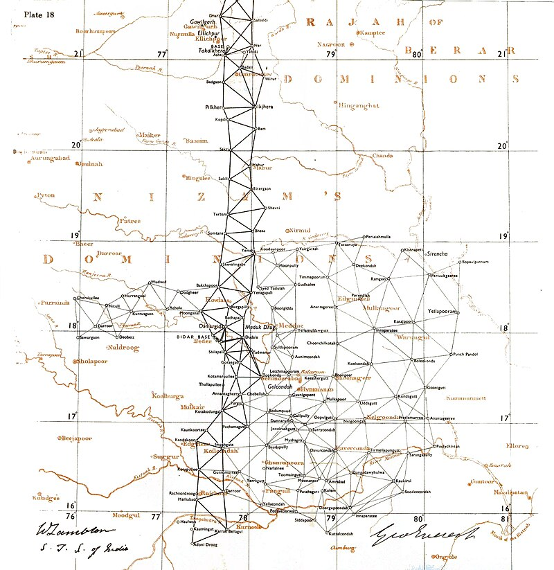
William Lambton & the Great Trigonometrical Survey of India
Accurate mapping has long been necessary for planning routes and understanding the lay of the land. One of the largest undertakings of this kind was the Great Trigonometrical Survey of India, begun in 1802 by William Lambton under the East India Company.

Lambton started his work at St. Thomas Mount near Chennai and gradually carried the survey northwards. His measurements reached Hinganghat in present-day Wardha district, where he spent many years completing observations for the meridional series. Notably, local accounts note that he spent about thirteen years in Hinganghat completing this part of the work. He died there in 1823 and was buried locally.
Hinganghat, along with Nagpur and Jabalpur (then Jubbulpoor), formed key points in the survey’s eastern section. By 1818, the work was formally named the Great Trigonometrical Survey of India. Wardha and surrounding areas appeared within the ‘Jubbulpoor Meridional Series’ and the ‘Great Arc Series’. The survey fixed key points across Wardha, creating a framework later used to map roads and settlements in detail.
Modes of Transportation in the District
Train & Rail Systems
Wardha district falls under the Central Railway zone, with Wardha Junction serving as the main station in the Nagpur Division. Major trunk routes passing through the district include the Bombay–Bhusawal–Nagpur–Howrah line and the Delhi–Madras Grand Trunk line, which together connect Wardha to major cities across India.
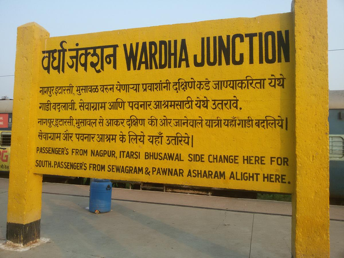
The development of railways in Wardha began during the British period. The Bombay–Bhusawal–Nagpur–Howrah line opened in 1867 and became an important link connecting Wardha to Mumbai, Jalgaon, Nagpur, and Kolkata. According to the Wardha district Gazetteer (1974), this line, at the time, ran “through the centre of the district with a length of about 65 km.”
The Delhi–Madras Grand Trunk line, which started operating in 1877, added further connections between North and South India. It is noted that stations such as Bhugaon, Sonegaon, and Hinganghat, which sit along this line, gained importance as stops for trade and transport. Hinganghat, in particular, was once a known centre for cotton and mint trading, which relied on the railway for access to wider markets.
Today, Wardha Junction remains an important hub for passenger travel and freight. Recent upgrades under the Railway Ministry’s station redevelopment plan have added new facilities and improved services for commuters. In addition, a new railway line from Wardha to Nanded is under construction. This project will connect Wardha more directly with the Marathwada region and is expected to strengthen local trade, industry, and travel.

Overview of Bus Networks
Wardha is served by a network of state-run and private buses that connect the district headquarters with nearby towns and villages. These services help residents travel for work, education, and access to markets.
Notably, the district’s bus network began in 1946. At the time, according to the district Gazetteer (1974), ten routes linked places such as Nagpur, Hinganghat, and Chandrapur, covering a total route length of about 503 km. This early expansion reflected an effort to meet the growing need for reliable public transport in the district.
Autos & Shared Vehicles
Auto rickshaws are a common mode of transport in Wardha but usually do not run on a meter system. Fares are agreed upon based on distance and can vary between areas. Many residents know local drivers personally and often arrange rides by calling them directly. App-based services such as Uber and Ola are not widely used in the district.
Ferries & Water Transport
Ferry crossings were once a common mode of transport in Wardha, providing connections across rivers before bridges were built. According to the District Gazetteer (1974), a ferry service operated on the Wana River and similar crossings were found in other parts of the district.
The Gazetteer also records that under the Hinganghat Panchayat Samiti, several villages — including Kapsi, Kanoli, and Hiwra — depended on ferries across the Wardha and Wana rivers. These crossings allowed people and goods to move during the monsoon months when road travel was difficult.
Similarly, in the Arvi Panchayat Samiti, villages such as Antardoh and Wadgaon used ferry services to reach markets and other essential places when flooding blocked road routes. While bridges now connect many of these areas year-round, ferries might still operate in some places.
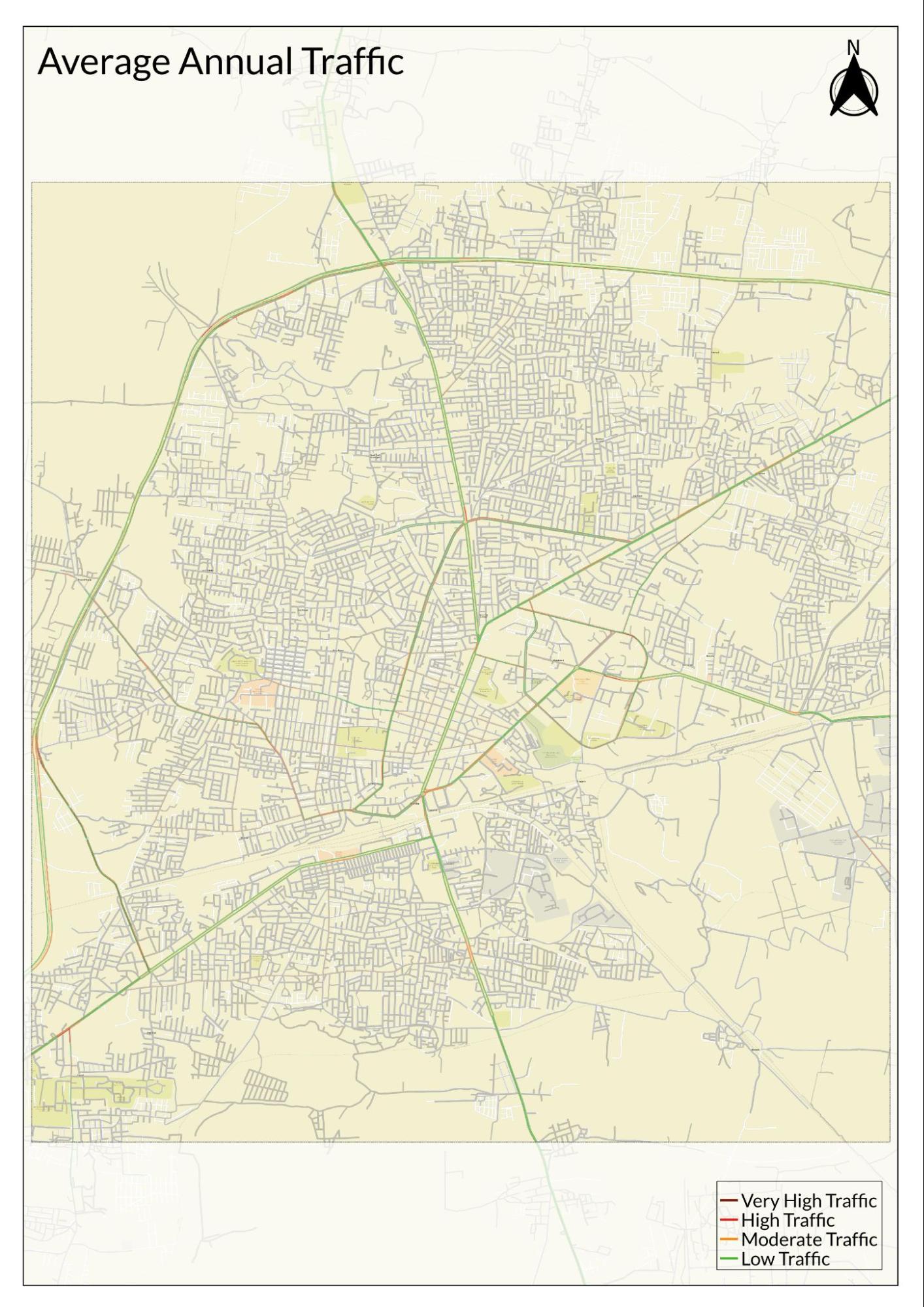
Traffic Map
Communication Networks
Newspapers & Magazines
At the time of the district Gazetteer’s (1974) publication, Wardha district had a number of newspapers and magazines in circulation. The Wardha Times, published in English, was described as the most important daily.
Other weeklies and magazines published in the district included Jagran, Navamat, Janata Shakti, Janasangram (Wardha), Pratapgadache Vare, Navivat, Age ki Bat, Wardha Weekly, Zanzavat (Hinganghat), Janheet Times (Arvi), Arvi Times, Janata (Wardha), Veer Vanavasi, Morcha, Adhyayan Bharati, Vikas Varta (magazine), Samyagog (Gopuri-Wardha), and Parthasarathi (Hinganghat). This range of publications points to local journalism being active in many parts of Wardha at the time.
Today, state-level dailies such as Lokmat and other Marathi newspapers carry dedicated local pages for Wardha, covering district news, events, and public notices alongside state and national reports.
Radio & Broadcasting
Wardha is home to several community radio stations that form an important part of the local media landscape. Radio Marg Darshan, run by the Marg Darshan Trust, has broadcast on 90.4 MHz FM since 2007. Radio Chhatrapati Shahu, operated by Chhatrapati Shahu Mahavidyalaya, broadcasts on 107.8 MHz FM, and Radio Prahar, managed by the Prahar Foundation, airs on 95.5 MHz FM.
These stations provide a range of programmes, including local news and discussions on current affairs. Music in Marathi and Hindi, from folk to popular genres, features alongside educational segments on topics such as health and agriculture. Cultural broadcasts highlight local traditions and arts, and interviews with local residents and experts add variety to the content.
Together, these community radio stations have built a loyal audience and continue to serve as a valued source of information and entertainment across the district.
Graphs
Road Safety and Violations
Transport Infrastructure
Bus Transport
Communication and Media
Sources
Anmol Dhawan. 2020. The Zero Stones of Pune and London; and Measuring the Whole Subcontinent. Syndrome.https://syndrome.home.blog/2020/04/09/the-ze…
Debala Mitra. 1984.Indian Archaeology 1981-82 - A Review.Archaeological Survey of India. New Delhi.
Devanjana Nag. 2019. Beautiful Indian Railways Gives a New Makeover to Wardha Junction Railway Station; see pics. The Financial Express.https://www.financialexpress.com/business/ra…
Kamal Mishra. 2024. Central Railways Wardha-Nanded New Railway Line Project Benefiting Passengers, Boosting Maharashtra's Economy. The Free Press Journal.https://www.freepressjournal.in/india/centra…
Kartik Lokhande. 2015. Hinganghat : Here Rests the Great Surveyor of India. Kartik Lokhande’s Blog.https://kartiklokhande.blogspot.com/2015/07/…
Maharashtra State Gazetteers. 1974.Wardha District.Directorate of Government Printing, Stationary & Publications, Government of Maharashtra, Mumbai.
Nishant Zodape. 2022.Archaeological remains of Buddhism at Early Historic Vidarbha (Maharashtra).Amoghvarta. Vol I, Issue III.
Tilok Thakuria. 2017.Society and Economy during Early Historic Period in Maharashtra: An Archaeological Perspective.Heritage: Journal of Multidisciplinary Studies in Archaeology. Vol. 5.
World Health Organization.Road Safety.WHO, Geneva.https://www.who.int/health-topics/road-safet…
Last updated on 6 November 2025. Help us improve the information on this page by clicking on suggest edits or writing to us.