Contents
- Physical Features
- Climate
- Geology
- Soil
- Minerals
- Rivers
- Botany
- Wild Animals
- Birds
- Forest Reserves
- Karanja Sohol Wildlife Sanctuary
- Land Use
- Environmental Concerns
- Water Pollution
- Climate Change Vulnerability
- Noise Pollution
- Graphs
- Water
- A. Rainfall (Yearly)
- B. Rainfall (Monthly)
- C. No. of Rainy Days in the Year (Taluka-wise)
- D. Evapotranspiration Potential vs Actual Numbers (Yearly)
- E. Annual Runoff
- F. Runoff (Monthly)
- G. Water Deficit (Yearly)
- H. Water Deficit (Monthly)
- I. Soil Moisture (Yearly)
- J. Seasonal Groundwater Levels: Bore Wells
- K. Seasonal Groundwater Levels: Dug Wells
- Climate & Atmosphere
- A. Maximum Temperature (Yearly)
- B. Maximum Temperature (Monthly)
- C. Minimum Temperature (Yearly)
- D. Minimum Temperature (Monthly)
- E. Wind Speed (Yearly)
- F. Wind Speed (Monthly)
- G. Relative Humidity
- Forests & Ecology
- A. Forest Area
- B. Forest Area (Filter by Density)
- C. Wildlife Projects (Area and Expenses)
- Human Footprint
- A. Nighttime Lights
- Sources
WASHIM
Environment
Last updated on 6 November 2025. Help us improve the information on this page by clicking on suggest edits or writing to us.
Physical Features
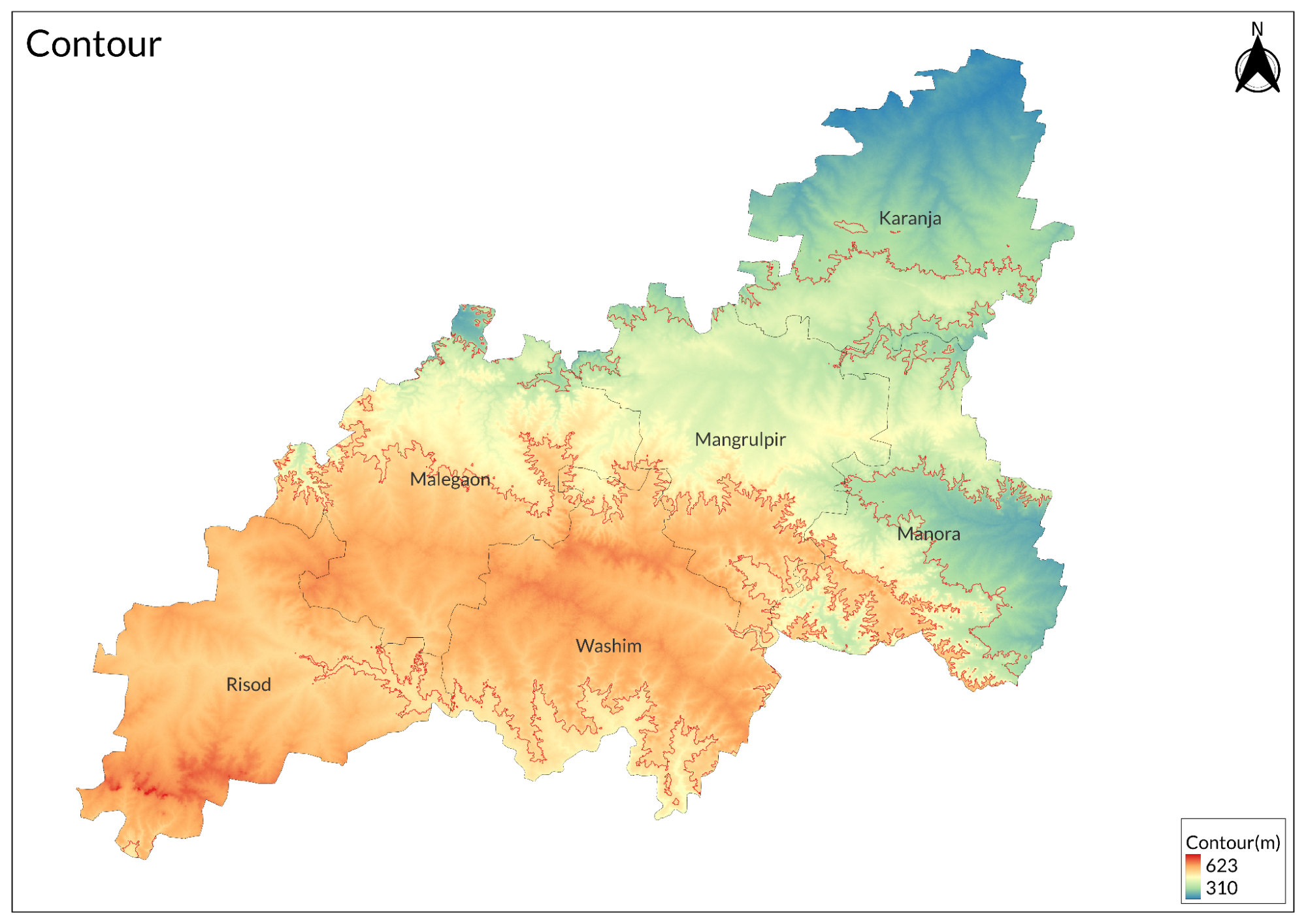
The district is part of the Deccan Plateau, with elevations ranging from 400 to 700 meters above sea level. The northern region consists of flat plains interspersed with low hills. The central area features undulating terrain with small valleys forming natural drainage channels. The southern portion has higher elevations that gradually slope towards the Penganga River basin, which forms the district's southern boundary.
The underlying geology is dominated by Deccan Trap basalt and hence has created characteristic step-like formations along water courses and hillsides. This directly influenced soil formation and local drainage patterns. Drainage in the district slopes southward, with a number of seasonal streams creating a dendritic pattern. The waterways created shallow valleys and natural depressions that act as water reservoirs.
Physical geography shaped land use patterns across Washim:
- Plains: Mainly for agricultural purposes
- Hilly regions: Provide forest cover and pastures
- River valleys: Fertile floodplains with potential for intensive agriculture
Climate
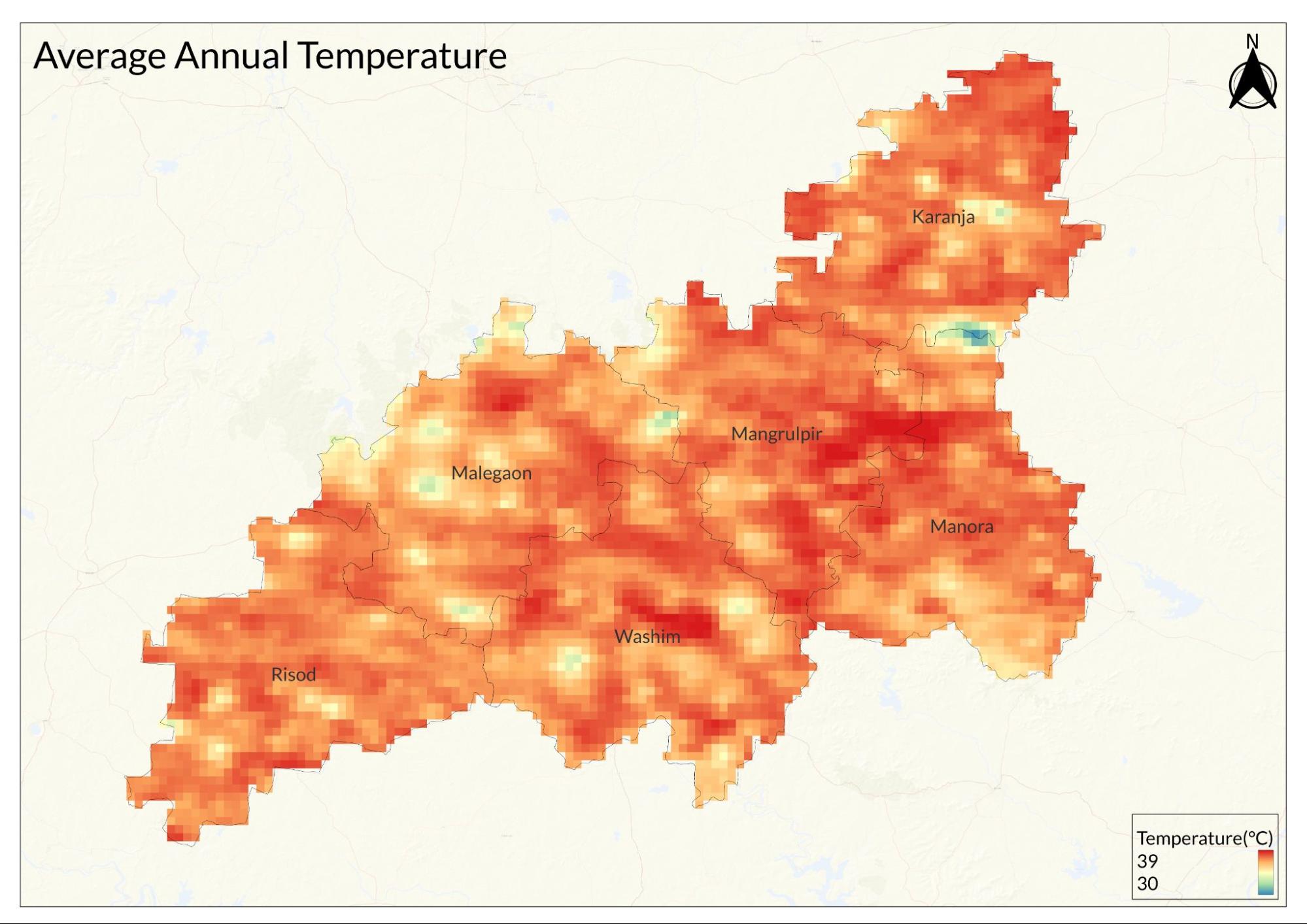
The tropical wet and dry climate of Washim district has three distinct seasons: summer, monsoon, and winter. Climate is mainly affected by the region's location in Vidarbha and its relative position with respect to monsoon systems.
The summer season falls between March and May, the hottest time of the year. Temperatures often rise to 45°C, especially in May, while minimum temperatures range around 30°C. This is a time of hot, dry winds and very low humidity levels of 15-20%. Pre-monsoon showers, locally called 'thunder showers,' occur at times in late May and offer temporary relief from the heat.
The monsoon season starts in June and goes up to September, thus bringing significant changes in the weather pattern. Average annual rainfall in the district is around 700-900 mm. July and August are the months when it rains the most. In this time, the humidity level rises to a huge extent, that is 65-80%, and the temperature ranges between 25-35°C. The southwest monsoon is the primary source of rainfall, though its distribution can be uneven across the district, with southern areas typically receiving more precipitation.
The winter season starts in November and continues till February. It is a pleasant season with temperatures ranging from 10°C to 25°C. December and January are the coldest months, with low humidity (30-40%) and clear skies. Western disturbances sometimes affect the winter season, but rainfall during this period is very less. Fog in the morning is common during winter months, especially in low-lying areas.
There are several types of weather phenomena occurring throughout the year in the district. Heat waves prevail during May-June, while thunderstorms are frequently observed during the pre-monsoon periods. Hailstorms occasionally occur during winter, but it is a relatively rare occurrence. Dry spells can affect agricultural activities during the monsoon season.
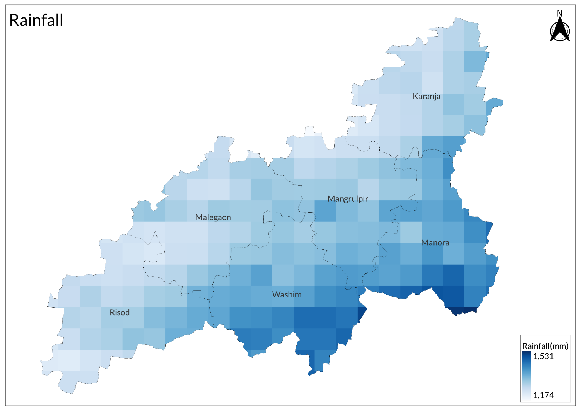
This climate pattern heavily influences the agricultural calendar of Washim. The Kharif (monsoon) cropping season coincides with the onset of the monsoon, while Rabi (winter) crops rely on residual soil moisture and irrigation. The district experiences rainfall for around 45-50 days every year, and the monsoon usually arrives in the second week of June and withdraws by the end of September.
Geology
The Washim district is underlain entirely by the Deccan Trap formations, which is a huge volcanic terrain that was developed during the Late Cretaceous to Early Eocene period, around 66-52 million years ago. These are part of the huge Deccan Volcanic Province characterizing much of west-central India's geology.
The district's geological framework is composed of multiple, horizontal layers of basaltic rock flows, ranging between 20 and 50 meters in thickness. These basalts are fine to medium grained and dark grey to black in color. Distinguishing features of the rocks include spheroidal weathering, where time will round the basalt into onion-like structures.
Between these massive basalt flows lie important intertrappean beds - thin sedimentary deposits that formed during pauses in volcanic activity. These beds contain fossilized remains and red bole horizons, which are crucial markers for understanding the region's geological history and the time gaps between successive volcanic events.
Structurally Washim has a general plunge toward south-southeast direction. The basalt succession in the area is full of fracture and joint systems along all the directions, yet several big lineaments trend NW-SE and NE-SW directions. These are the main controlling factors for its groundwater flow and drainage course.
Soil
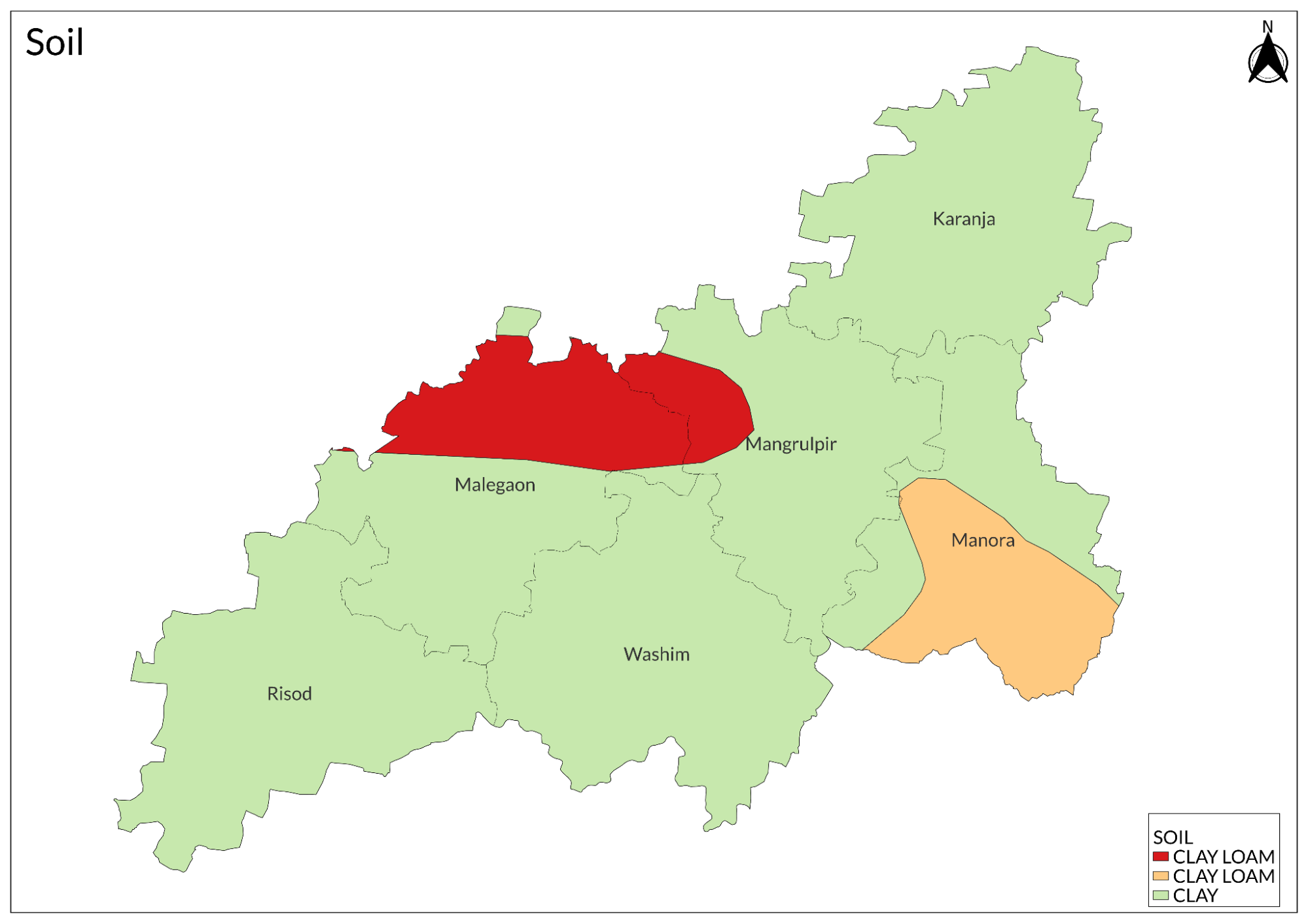
The Black Cotton Soil is locally known as Regur. These soils often extend more than one meter deep into lowland plains and valleys. This kind of soil contains a great deal of clay, most particularly montmorillonite, with very good capacity to retain moisture, high fertility, but unfortunately, has several shortcomings, such as getting waterlogging in wet spells, while on the other hand, develops deep cracks at periods of dry weather.
Medium Black Soils occupy the gently sloping areas, especially in the middle parts of the district. The depths range between 30 and 100 centimeters. These soils contain moderate clay content with better drainage characteristics than deep black soils. They are versatile and support a wide variety of crops, making them very valuable for agricultural purposes.
In the upper slopes of the district, Shallow Black Soil predominates with depths less than 30 centimeters. These soils, mixed with rock fragments, have a low water holding capacity but are ideal for drought-resistant crops. Their shallow nature and position on slopes make them less ideal for intensive agriculture but they support specific types of cultivation adapted to these conditions.
Murrum Soil, derived from weathered basalt, is found in the hilly areas of the district. This soil type has a high gravel and rock pieces content, which means it retains very little water. It has little agricultural value but is an important resource for road construction and other infrastructure development projects.
Minerals
The mineral resources of Washim district are closely related to its basaltic geological foundation. Construction materials form the primary mineral wealth of the region, with building stone (basalt) being the most abundant resource. These stones, along with road metal, sand, gravel, and brick clay, support the local construction industry and infrastructure development.
The district contains several industrial minerals, though in relatively minor quantities. Among these are deposits of zeolites, calcite, quartz, and a variety of clay minerals. Although not extensively mined, these minerals contribute to small-scale industrial activities in the region.
Rivers
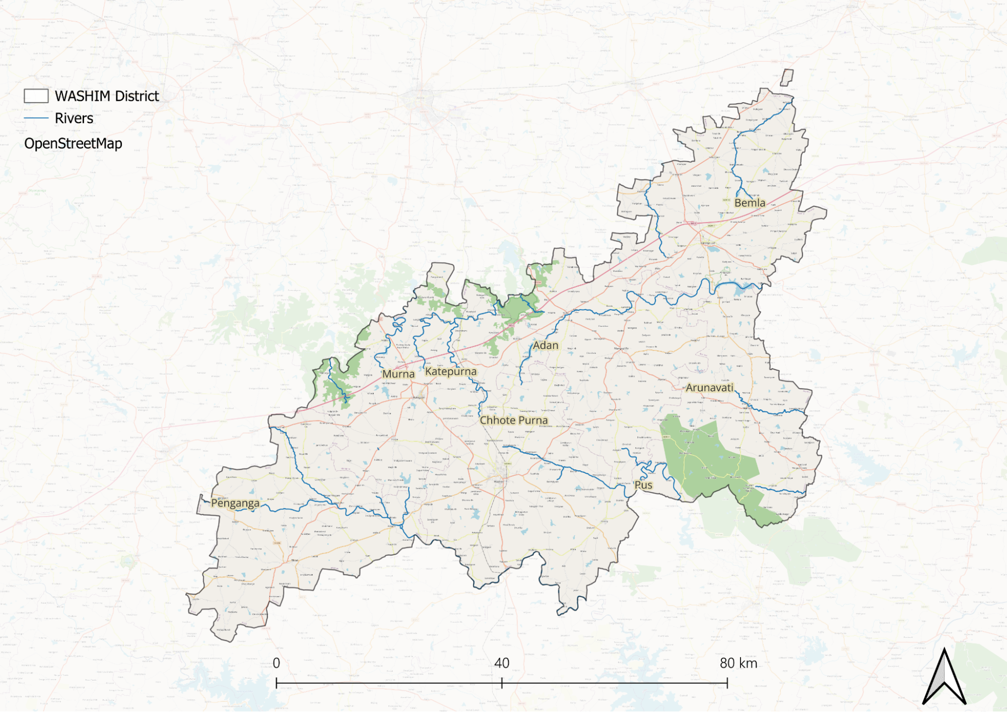
Several seasonal streams and nullahs form a dendritic drainage pattern across the district. These water channels are mainly rain-fed and are active during the monsoon season, which occurs from June to September. The drainage pattern is dominated by the underlying geological structure; many streams follow natural joints and fractures in basaltic rock.
Botany
The Southern Tropical Dry Deciduous Forests make up the majority of Washim district's vegetation. These forests are divided into three distinct layers, each made up of different species. The upper canopy is covered by Teak, Ain, and Dhawda. The middle layer includes Tendu, Babul, and Khair. The understory consists of medicinal plants like Adulsa, Nirgudi, and other grass species like Aristida and Heteropogon.
The main crops grown here are cotton, soybean, and pigeon pea, which thrive well in the black soil of the district. Jowar, wheat, rice, chickpea, and green gram are food crops. Commercial crops include groundnut, sunflower, and vegetables. Fruit crops comprise citrus, mango, and guava.
Wild Animals
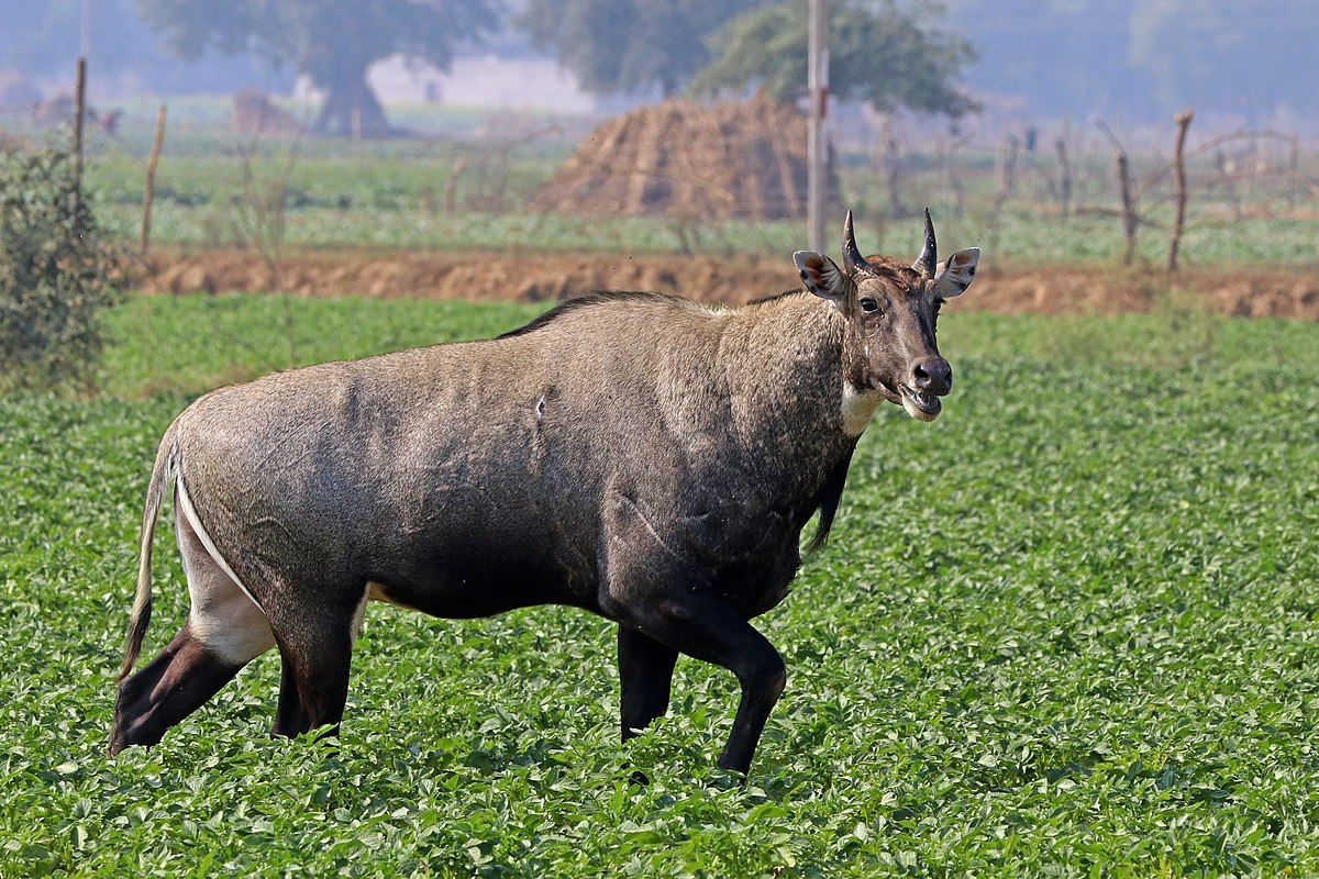
The most common large carnivores spotted are the Indian Leopard. Striped Hyena, occasionally, and Indian Wolf spotted rather frequently in grassland/woodland areas. Among small carnivores, most widely distributed are Golden Jackal, Indian Fox, Jungle Cat, and Small Indian Civet. Blackbuck and Chinkara are found in open regions.
Smaller mammals include Indian Hare, Indian Grey Mongoose, and Indian Palm Squirrel. These species maintain stable populations despite human encroachment.
Birds
Washim houses many notable species, including the Indian Peafowl, Grey Junglefowl, and Indian Grey Hornbill. It also provides habitat for the Rose-ringed Parakeet and Spotted Owlet, which are frequently seen amidst the tree cover.
A distinct set of birds inhabits the grasslands and agricultural fields of the district. These areas have frequent sightings of Indian Roller and Common Myna. Scrub lands support Grey Francolin, whereas Indian Bushlark inhabits open grasslands. The weaverbirds and munias form a good assemblage in these agricultural lands.
Wetland habitats attract their own distinct bird communities. Little Cormorant, White-breasted Waterhen, and Common Moorhen are regular residents of these water bodies. During winter months, these areas become particularly important as they host numerous migratory ducks and waders.
The district's raptor population is particularly notable. Black-winged Kite, Shikra, and Short-toed Snake Eagle are residents; the winter season adds other species to the raptors, with some harriers patrolling grasslands and agricultural fields, searching for prey.
Forest Reserves
Karanja Sohol Wildlife Sanctuary
Karanja Sohol Wildlife Sanctuary is a protected area located in the Washim district's Karanja taluka, Maharashtra. Established in 2000, the sanctuary has forest and grasslands, with an area of approximately 1,832 hectares. It is about 7 km from Karanja town. The area contains undulating hills and comes under the catchment area of the Aadan reservoir. The flora of the sanctuary is a tropical and subtropical dry broadleaf forest. Teak, Coromandel Ebony, Ain, and Axlewood are dominant tree species. The habitat has grasslands with pockets of wooded lands. This wild life population includes 17 species of mammals, 75 of bird species, 18 species of reptiles, 3 species of amphibians, 23 species of fish, and 48 species of butterfly and spider. Noted are the Indian Muntjac, Striped Hyena, Sambar Deer, Jungle Cat, and Wild Boar. The site is specifically renowned for conservation efforts for the Black Buck and an important habitat for migratory waterfowl between November and March.
Management of the sanctuary is done according to a plan that was approved in 2009 for the period of 2009-2019, with habitat conservation and species preservation as focus areas. The sanctuary is accessible by road from Washim, while Murtizapur is the nearest railway station.
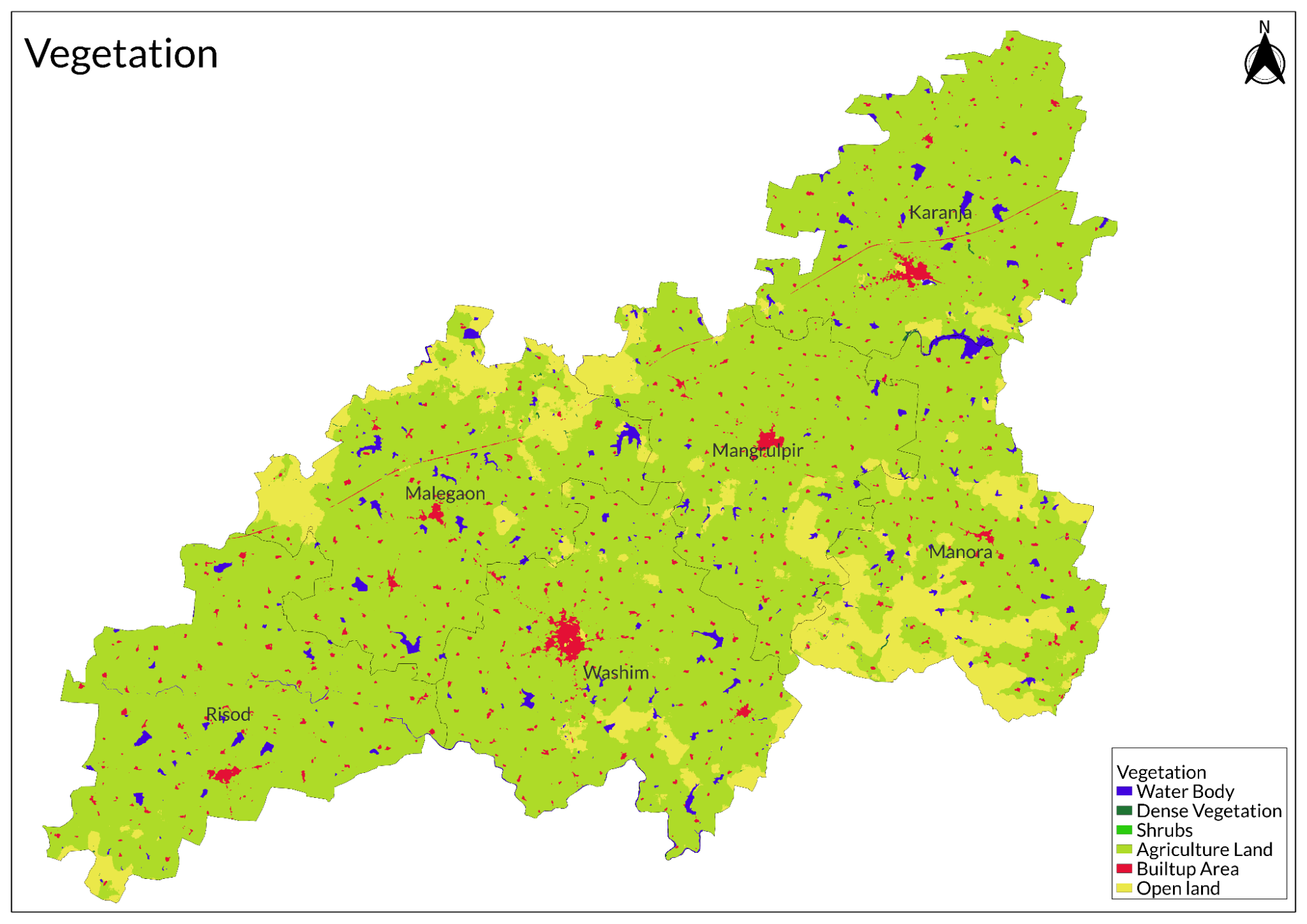
Land Use
Environmental Concerns
Water Pollution
According to findings from the Maharashtra Public Health Laboratory, up to 27% of the tested samples from Washim are polluted, with alarming levels of contaminants such as chloride and salinity. This situation makes Washim one of the most affected districts in the state regarding water quality.
The primary sources of pollution in Washim include agricultural runoff, industrial waste discharge, and inadequate domestic waste management. Agricultural practices in the region often involve excessive use of fertilizers and pesticides, which can lead to runoff that contaminates local water bodies. Additionally, improper disposal of industrial wastewater from facilities, including pig iron plants, contributes significantly to high chemical levels in water sources. Domestic waste is another critical factor; the lack of proper sewage treatment systems results in untreated wastewater entering rivers and streams. Specific pollutants of concern include elevated chloride levels and high salinity in water samples from the district. These contaminants pose serious risks to both human health and the environment. Furthermore, there is a potential presence of heavy metals in the water, depending on local industrial activities.
Recent studies have shown that groundwater quality is also compromised, with various analyses indicating that many samples fail to meet safety standards for drinking purposes. For instance, a study conducted on groundwater resources in Washim revealed that water quality indices (WQI) varied significantly, indicating varying levels of pollution across different seasons.
Climate Change Vulnerability
Washim district in Maharashtra is highly vulnerable to climate change, facing significant risks from droughts, erratic rainfall patterns, and extreme temperatures. These changing weather conditions pose a substantial threat to agriculture, which is the primary livelihood for most residents in the district. A recent study conducted by the Indian Council of Agricultural Research (ICAR) revealed that 11 out of 36 districts in Maharashtra, including Washim, are classified as highly vulnerable to extreme weather events, accounting for nearly 40% of the state's cropped area. This vulnerability is particularly concerning given that about 51% of Maharashtra's population relies on agriculture for their livelihood.
The district's susceptibility to drought is aggravated by unpredictable and often insufficient rainfall, severely impacting crop production. Increasing average temperatures further stress crops and reduce water availability, leading to diminished yields. Additionally, erratic rainfall patterns—characterized by heavy downpours followed by prolonged dry spells—disrupt farming practices and contribute to soil erosion. As a result, farmers in Washim face significant challenges that threaten their income and food security. According to Chaitanya Adhav from ICAR, the extreme climate conditions are expected to adversely affect the production of key crops such as jowar, rice, wheat, and cotton. The need for focused policy efforts to address these vulnerabilities is urgent. Experts suggest that while discussions around climate change impacts on agriculture are prevalent, actionable measures on the ground remain limited. Strategies such as changing crop patterns and implementing sustainable farming practices are essential for enhancing resilience against climate change.
Noise Pollution
Noise pollution in Washim district, Maharashtra, has emerged as a significant environmental concern, primarily driven by rapid urbanization, industrialization, and increased vehicular traffic. The study conducted by Anant D. Dhole and Dr. Prashant A. Kadu highlights how excessive noise levels disrupt the quality of life for residents and can adversely affect both physical and mental health. Noise pollution is defined as sound levels in the environment that are disturbing or irritating to living beings, leading to issues such as annoyance, aggression, hypertension, stress, hearing loss, and sleep disturbances.
As Washim town develops and attracts more people from surrounding rural areas, the population growth has intensified noise-related problems. The study aimed to measure noise levels across different zones in Washim to assess compliance with standards set by the Central Pollution Control Board (CPCB). The findings revealed that noise levels often exceed these permissible limits, particularly in commercial and residential areas.
The research utilized a digital sound level meter to record noise samples at various locations, including institutional, commercial, silence, and residential zones. Results indicated that traffic noise is a primary contributor to overall noise pollution in the district. With increasing vehicle numbers and construction activities, the ambient noise levels have risen alarmingly.
Moreover, the study emphasizes the need for effective noise management strategies to mitigate the impact of pollution on community health. Recommendations include implementing noise barriers, improving urban planning to reduce traffic congestion, and raising public awareness about the effects of noise pollution.
Graphs
Water
Climate & Atmosphere
Forests & Ecology
Human Footprint
Sources
International Journal of Engineering Sciences & Research Technology (IJESRT). 2018.Study on Environmental Impact and Water Quality in Wardha District. IJESRT, April 2018 Edition.https://www.ijesrt.com/Old_IJESRT/issues%20p…
Moneycontrol. 2021. 77% of Maharashtra's Cropped Area Vulnerable to Climate Change, Study Finds. Moneycontrol News & Reports.https://www.moneycontrol.com/news/india/77-o…
Times of India. 2018. More Than 30 Maharashtra Districts Facing Water Contamination: Report.Times of India.https://timesofindia.indiatimes.com/city/mum…
Wikipedia. Karanja Sohol Wildlife Sanctuary. Wikipedia, The Free Encyclopedia.https://en.wikipedia.org/wiki/Karanja_Sohol_…
Wikipedia. Wardha River. Wikipedia, The Free Encyclopedia.https://en.wikipedia.org/wiki/Wardha_River
Last updated on 6 November 2025. Help us improve the information on this page by clicking on suggest edits or writing to us.